Region
Lochaber
Ben Nevis, the Mamores, Knoydart — the heartland of Scottish mountaineering.
- Munros
- 82
- Corbetts
- 60
- Grahams
- 45
- Bothies
- 12
- Trail centres
- 2
- Long-distance trails
- 4
- Wild swimming
- 9
- Gravel routes
- 4
- Dark sky sites
- 4
- Highest peak
- Ben Nevis (Beinn Nibheis) (1344.53m)
Lochaber is where Scottish mountaineering grew up. Ben Nevis is the obvious headline — the UK's highest mountain, 100,000 ascents a year, a north face that is still the benchmark for Scottish winter climbing. But the region is much more than one mountain. The Mamores stretch east from Ben Nevis across fourteen Munros in a single ridge. Glen Coe cuts south, its three famous buttresses — the Aonach Eagach, Buachaille Etive Mòr, and Bidean nam Bian — as recognisable as any mountain scenery in Britain. Ardnamurchan and Ardgour extend west towards the most remote mainland peninsula in Scotland.
Fort William is the main base — it's not a beautiful town but it's a functional one, with gear shops, supermarkets, accommodation at every price point, and a direct rail connection via the West Highland Line from Glasgow. The Jacobite steam train to Mallaig crosses the Glenfinnan Viaduct twice daily in season and is worth doing once. The scenery on the train is genuinely exceptional.
Knoydart sits offshore from everything, reachable by a 7-mile boat crossing from Mallaig or a two-day walk across rough country. It is the most remote inhabited mainland settlement in Britain. The pub in Inverie is real, the Munros above are serious, and the whole peninsula is unlike anywhere else in Scotland.
Glens4 glen guides
All glens →
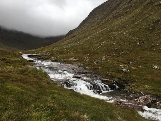
Glen Coe
Scotland's most dramatic glacial glen — dark history, serious ridges, and the constant weight of big mountains on every side.
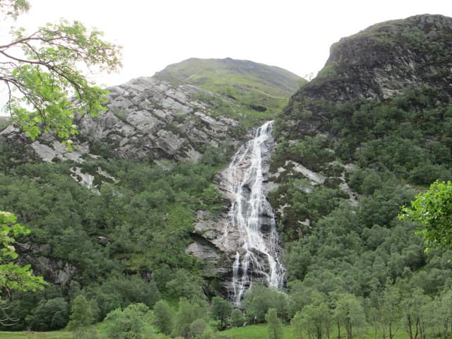
Glen Nevis
The glen under Britain's highest mountain — a gorge walk, a wire bridge, a 120m waterfall, and a 7-hour slog to the top.
Glen Etive
Nineteen miles of single-track dead end — river pools, Skyfall scenery, and midges that will eat you alive if you stop moving.
Glen Roy
The Parallel Roads National Nature Reserve — three glacial lake shorelines etched into the hillsides like contour lines drawn by giants.
Hills82 Munros · 60 Corbetts · 45 Grahams
Long-distance trails
Bothies12 in this region
Mountain biking
Wild swimming9 spots
Gravel cycling4 routes
Wild camping
Dark sky & northern lights4 sites
Map
Hills (dark/mid green), bothies (brown), wild swimming (blue), dark sky (purple).
Getting there
Glasgow
2.5 hr drive
Edinburgh
2.5 hr drive
Inverness
2 hr drive
Guided support for Lochaber
If you'd prefer a guided experience, these operators run trips in this area.
Wilderness Scotland
Premium guided expeditions, all regions
Macs Adventure
Self-guided LDP specialists
Hillwalk Tours
Self-guided routes, luggage transfer
Absolute Escapes
Edinburgh-based independent operator
Affiliate links — disclosure
Our take
The tourist route up Ben Nevis (the Mountain Track, sometimes called the Pony Track) is perfectly safe in good conditions and perfectly dangerous in bad ones — it kills people every year, mostly from exposure and from falling in the upper corrie. Do not attempt it in winter without crampons, ice axe, and the knowledge to use both. In summer, the main hazard is underestimating the weather change at altitude. Start early, carry waterproofs, and don't be the person descending in jeans at 5pm in the rain.
The Aonach Eagach above Glen Coe is the most committing ridge walk on the Scottish mainland — you cannot easily reverse it once you're committed, and it requires competent scrambling. The standard approach is west-to-east, starting at Am Bodach. Do not attempt it in wet or icy conditions without scrambling experience. For a first-timer to the area, the Buachaille — specifically Stob Dearg via the Coire na Tulaich path — is a much better introduction to Glen Coe: big views, manageable terrain, genuinely rewarding.
Track your Lochaber hills
Log your completions across the Lochaber hills and plan your next route.
Open Hill Tracker →Explore nearby regions
Scotland outdoor updates
Route guides, condition reports and seasonal picks — once a week, no noise.
Around Lochaber on the SCOT network
Sister sites covering food, drink and travel context for the same area. Linked direct.
Highland whisky region
40 distilleries spanning the largest and most varied of Scotland's whisky regions.
tastescot.co.uk
On TripSCOTFort William
Ben Nevis base, West Highland Line, gateway to Lochaber
tripscot.co.uk
On TripSCOTMallaig
Ferry port for Skye and the Small Isles; CWT finish supply
tripscot.co.uk
On TripSCOTIsle of Lismore
Long lime-rich island in Loch Linnhe; ferry from Oban
tripscot.co.uk