Munro · Kintail
Mam Sodhail
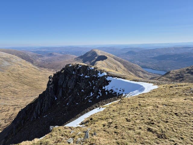
Mam Sodhail is the 1179m Munro at the head of Glen Affric, second-highest peak north of the Great Glen and the southern twin of Carn Eighe. The summit carries the substantial stone-built ruin of one of the great Victorian Ordnance Survey signal stations, used as a primary triangulation point for the 1840s national survey. The view is one of the broadest in the Highlands — west to Skye and the Cuillin, south to Ben Nevis, north into the wild Mullardoch country.
Quick facts
- Height
- 1179.4m/ 3869ft
- Prominence
- 132 m
- Distance
- 19 km
- Ascent
- 1038 m
- Time
- 7–11 hrs
- Grid ref
- NH120253
- Parking
- NH200234
- Nearest
- Fort William· Inverness 58km
- Dogs
- Dogs on lead required near livestockDog-friendly guide ↗
Height and prominence cross-checked against the Database of British and Irish Hills (CC BY).
No GPX track yet
Walked this route? Share your track to help other walkers.
Standard route
Glen track 40% · Open hillside 30% · Summit ridge 30%
Reach the hill from the road end at Loch Affric (NH200234), following the well-built stalkers paths south up Glean nam Fiadh or west into Coire Leachavie. From either, climb onto the broad south ridge and follow it to the summit. Around 22km return with 1038m of ascent. Almost always combined with Carn Eighe via the connecting bealach — the ridge between the two is one of the finest in the country.
Terrain
The Glen Affric paths are excellent stalkers tracks for the lower hill. The Coire Leachavie ascent is steep grass and rock with a clear path; the ridge above is broad short turf with no exposed sections. The summit area is a wide stony platform dominated by the OS station ruin — a useful landmark in mist. The connecting bealach with Carn Eighe is broad and undemanding.
In winter
A serious winter undertaking. The Coire Leachavie face holds avalanche risk after westerly storms. The summit ridge and the connection to Carn Eighe both develop cornices on the north side. The OS station ruin gives some shelter but is not safe accommodation in real weather. Phone signal is absent; full winter self-sufficiency required. SAIS Northern Highlands applies.
Best time of year
Getting there
- Glasgow3h 12m
- Edinburgh4h 38m
OS maps: OS Landranger 25
Mobile signal: Signal-free from start to summit in Glen Affric. Very remote glen — download offline maps and carry emergency communication.
Current conditions
Daylight Today
- Sunrise
- 05:00
- Sunset
- 21:54
- Civil dawn
- 04:03
- Civil dusk
- 22:51
NOAA Solar Calculator · 23 July 2026
Pair with
Curated multi-hill combinations from Mam Sodhail.
On a long-distance route
Mam Sodhail sits within 5km of these named long-distance walks — useful for trail-pack rest days or section extensions.
Around Mam Sodhail on the SCOT network
Getting there, basing yourself, and what to do off the hill.
Mam Sodhail — common questions
- How difficult is Mam Sodhail?
- Mam Sodhail carries a 5/5 (very challenging) grade on the OutdoorSCOT scale. Count on about 19km, 1038m of ascent and a 7-11 hour day on the standard route. Underfoot: The Glen Affric paths are excellent stalkers tracks for the lower hill.
- What is Mam Sodhail's prominence?
- 132m of prominence. That's the vertical drop from the summit to the col that links Mam Sodhail to the next higher ground.
- Where do I park for Mam Sodhail?
- Most walkers start from NH200234 near Fort William. Verify the grid reference on an OS map before you set off — space is tight on busy summer weekends.
- When is the best time to climb Mam Sodhail?
- May, June, July, August, September, October give the most reliable conditions on Mam Sodhail. Beyond that window the high ground turns wintry: carry full mountain kit, be confident navigating, and check the SAIS avalanche forecast for the area.
- Is Mam Sodhail dog-friendly?
- Yes, but dogs must be kept on a lead — there is livestock or ground-nesting bird interest on the route.
- Is there mobile signal on Mam Sodhail?
- Signal-free from start to summit in Glen Affric. Very remote glen — download offline maps and carry emergency communication.
- Is Mam Sodhail safe in winter?
- A serious winter undertaking. The Coire Leachavie face holds avalanche risk after westerly storms. The summit ridge and the connection to Carn Eighe both develop cornices on the north side. The OS station ruin gives some shelter but is not safe accommodation in real weather. Phone signal is absent; full winter self-sufficiency required. SAIS Northern Highlands applies.
Get the OutdoorSCOT weekly
One email a week — new route, hill and bothy guides, seasonal conditions and the odd hard-won lesson. No spam, unsubscribe in one click.