Corbett · Central Highlands
Carn a' Choire Ghairbh
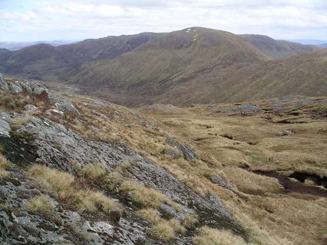
Carn a' Choire Ghairbh — "cairn of the rough corrie" — sits in the rolling Highland country between Glen Affric and Glen Loyne, twin to Aonach Shasuinn on the same broad ridge. At 862m it is a Corbett of moor and small crag rather than mountain drama, but the position high above the Affric watershed gives extensive views into one of the most attractive glens in Scotland. Most baggers tackle it together with Aonach Shasuinn from a Cluanie base.
Gaelic: “cairn-topped hill, of the, corrie” · Pronunciation: karn uh chor-a ghairbh
Quick facts
- Height
- 862.5m/ 2830ft
- Prominence
- 199 m
- Distance
- 15 km
- Ascent
- 759 m
- Time
- 5–7 hrs
- Grid ref
- NH136188
- Parking
- NH090118
- Nearest city
- Fort William· 45km
- Dogs
- Dogs on lead required near livestockDog-friendly guide ↗
Height and prominence cross-checked against the Database of British and Irish Hills (CC BY).
No GPX track yet
Walked this route? Share your track to help other walkers.
Standard route
dam track 35% · rough moor 40% · broad ridge 20% · summit cairn 5%
Start from the lay-by on the A87 east of the Cluanie Inn and follow the dam-side track into the upper reaches of the Allt na Ciche. After a few kilometres the track ends; climb pathless heather and grass north onto the broad ridge that links Aonach Shasuinn with Carn a' Choire Ghairbh. The summit is the western and slightly higher of the two tops. Around 15km return with 759m of ascent for the pair.
Terrain
The Cluanie dam track is firm but the side-glen path beyond it is faint and wet. The open hillside above is rough heather and peat hag with no path; expect slow going on the climb to the ridge. The summit area is broad short grass with a small cairn — featureless enough to be confusing in poor visibility. No exposure or scrambling anywhere on the hill.
In winter
A genuine winter day despite the modest height — the long approach across exposed moor catches the full force of any easterly wind sweeping from the Cluanie tops, and the featureless plateau is a navigation trap in cloud. No avalanche slopes of consequence but cornicing on the north edge above Glen Affric. The A87 is gritted and the Cluanie Inn lay-by reliably accessible.
This hill is in the Creag Meagaidh SAIS forecast area. Check SAIS forecasts in winter (December–April).
Best time of year
Getting there
- Glasgow3h 5m
- Edinburgh4h 31m
OS maps: OS Landranger 34
Mobile signal: EE/Vodafone usable around the Cluanie Inn; nothing beyond the dam
Current conditions
Daylight Today
- Sunrise
- 04:43
- Sunset
- 22:09
- Civil dawn
- 03:41
- Civil dusk
- 23:11
NOAA Solar Calculator · 13 July 2026
On a long-distance route
Carn a' Choire Ghairbh sits within 5km of these named long-distance walks — useful for trail-pack rest days or section extensions.
Around Carn a' Choire Ghairbh on the SCOT network
Getting there, basing yourself, and what to do off the hill.
Carn a' Choire Ghairbh — common questions
- How hard is Carn a' Choire Ghairbh?
- We grade Carn a' Choire Ghairbh at 3/5, which puts it in moderately challenging territory. The usual route is around 15km with 759m of climbing; allow 5-7 hours. Ground conditions: The Cluanie dam track is firm but the side-glen path beyond it is faint and wet.
- How much drop does Carn a' Choire Ghairbh have?
- The drop is 199m: measured from the summit of Carn a' Choire Ghairbh down to the saddle joining it to higher terrain.
- Where's the parking for Carn a' Choire Ghairbh?
- Park at NH090118. Double-check the grid reference on an OS map first; informal laybys here fill early in high season.
- What's the best month to climb Carn a' Choire Ghairbh?
- Aim for May, June, July, August, September, October on Carn a' Choire Ghairbh. In the remaining months treat it as a winter hill — full kit, solid navigation, and a look at the relevant SAIS avalanche forecast before you go.
- Can dogs go up Carn a' Choire Ghairbh?
- Dogs are fine on a lead. The route passes livestock or ground-nesting bird habitat, so keep them close throughout.
- Will I get phone signal on Carn a' Choire Ghairbh?
- EE/Vodafone usable around the Cluanie Inn; nothing beyond the dam
- Is Carn a' Choire Ghairbh safe in winter?
- A genuine winter day despite the modest height — the long approach across exposed moor catches the full force of any easterly wind sweeping from the Cluanie tops, and the featureless plateau is a navigation trap in cloud. No avalanche slopes of consequence but cornicing on the north edge above Glen Affric. The A87 is gritted and the Cluanie Inn lay-by reliably accessible.
Get the OutdoorSCOT weekly
One email a week — new route, hill and bothy guides, seasonal conditions and the odd hard-won lesson. No spam, unsubscribe in one click.