Corbett · Cluanie
Am Bathach
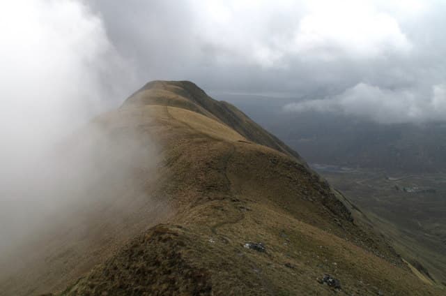
Am Bathach — 'the byre' — is the 798m Corbett at the eastern end of Loch Cluanie, looking south at the Cluanie Inn and the long ridge of South Glen Shiel Munros. The mountain is the smaller, lower partner of the Cluanie ridge — a short, sharp ascent that gives one of the most efficient summit-views-per-effort of any Corbett in the area. Often tacked onto a Cluanie Munro round as a quick afternoon top.
Quick facts
- Height
- 798.1m/ 2618ft
- Prominence
- 232 m
- Distance
- 7 km
- Ascent
- 530 m
- Time
- 2–3 hrs
- Grid ref
- NH073143
- Parking
- NH079117
- Nearest city
- Fort William· 40km
- Dogs
- Dogs on lead required near livestockDog-friendly guide ↗
Height and prominence cross-checked against the Database of British and Irish Hills (CC BY).
No GPX track yet
Walked this route? Share your track to help other walkers.
Standard route
forest path 25% · heather hillside 40% · grassy ridge 25% · summit area 10%
Park at the Cluanie Inn or the small layby just east on the A87 (NH079117). Walk along the road briefly and pick up the path heading north past the conifer plantation, climbing onto the broad south ridge of Am Bathach. A consistent climb across grass and rock outcrops brings you to the summit; the top is marked by a small cairn beside a rocky knob. Allow 3–4 hours.
Terrain
Faint path on the ascent through plantation, then open grass. The upper ridge is firmer with small rocky steps; the summit is a small cairn beside a rock outcrop. Short and uncomplicated — a useful Corbett day for poor-weather Cluanie visits.
In winter
A short and accessible winter Corbett near the Cluanie Inn. Snow holds on the upper ridge through January and February in most years. Cold easterlies funnel along Loch Cluanie. No avalanche concerns on the south ridge. A useful winter introduction Corbett with the Cluanie Inn for warming up afterwards.
Best time of year
Getting there
- Glasgow3h 2m
- Edinburgh4h 31m
OS maps: OS Landranger 33
Mobile signal: Nothing in upper Glen Affric area
Current conditions
Daylight Today
- Sunrise
- 04:44
- Sunset
- 22:09
- Civil dawn
- 03:42
- Civil dusk
- 23:11
NOAA Solar Calculator · 13 July 2026
Around Am Bathach on the SCOT network
Getting there, basing yourself, and what to do off the hill.
Am Bathach — common questions
- What difficulty is Am Bathach?
- On the OutdoorSCOT scale, Am Bathach comes in at 2/5 — moderate. Expect roughly 7km and 530m of ascent on the usual route — 2-3 hours for most parties. Underfoot: Faint path on the ascent through plantation, then open grass.
- What is Am Bathach's prominence?
- 232m of prominence. That's the vertical drop from the summit to the col that links Am Bathach to the next higher ground.
- Where do I park for Am Bathach?
- Most walkers start from NH079117. Verify the grid reference on an OS map before you set off — space is tight on busy summer weekends.
- When is the best time to climb Am Bathach?
- April, May, June, July, August, September, October give the most reliable conditions on Am Bathach. Beyond that window the high ground turns wintry: carry full mountain kit, be confident navigating, and check the SAIS avalanche forecast for the area.
- Is Am Bathach dog-friendly?
- Yes, but dogs must be kept on a lead — there is livestock or ground-nesting bird interest on the route.
- Is there mobile signal on Am Bathach?
- Nothing in upper Glen Affric area
- Is Am Bathach safe in winter?
- A short and accessible winter Corbett near the Cluanie Inn. Snow holds on the upper ridge through January and February in most years. Cold easterlies funnel along Loch Cluanie. No avalanche concerns on the south ridge. A useful winter introduction Corbett with the Cluanie Inn for warming up afterwards.
Get the OutdoorSCOT weekly
One email a week — new route, hill and bothy guides, seasonal conditions and the odd hard-won lesson. No spam, unsubscribe in one click.