Corbett · Knoydart
Druim nan Cnamh (Beinn Loinne)
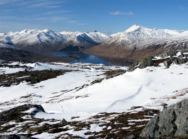
Druim nan Cnàmh — 'the ridge of bones' — is the long whaleback Corbett rising between Loch Loyne and Glen Loyne, north of the Cluanie Inn. The 789m summit sits at the highest point of a broad east-west ridge that connects loosely to the Cluanie Munros via a series of grassy bealachs. Also known as Beinn Loinne in some older guides. The walk crosses open Cluanie country with a sense of empty space and stalking-estate quiet typical of the area.
Quick facts
- Height
- 789m/ 2589ft
- Prominence
- 354 m
- Distance
- 13 km
- Ascent
- 670 m
- Time
- 3–5 hrs
- Grid ref
- NH130076
- Parking
- NH130090
- Nearest city
- Fort William· 34km
- Dogs
- Dogs on lead required near livestockDog-friendly guide ↗
Height and prominence cross-checked against the Database of British and Irish Hills (CC BY).
No GPX track yet
Walked this route? Share your track to help other walkers.
Standard route
loch-side path 20% · rough heather 45% · grassy upper slopes 25% · summit area 10%
Park at the Cluanie dam layby on the A87 (NH130090). Cross the road and follow a stalkers' path heading south-east along Loch Loyne for around 3km. From the loch shore, climb north onto the broad east ridge of Druim nan Cnàmh. The route gains the summit along a grassy whaleback with a small cairn on a rocky outcrop. Allow 5–6 hours.
Terrain
Reasonable stalkers' path along the loch — sometimes boggy. Above the loch the going is heather and grass on broad open slopes. The summit ridge is wide and gently undulating with no rocky difficulties; the cairn is small and sits on a rocky outcrop.
In winter
Snow lies well on the broad ridge from January through March. The A87 at the Cluanie dam is reliably ploughed. Easterlies coming down Glen Cluanie can be ferocious on the exposed top. No avalanche concerns on the standard ascent — a friendly winter Corbett for the area.
Best time of year
Getting there
- Glasgow3h 11m
- Edinburgh3h 21m
OS maps: OS Landranger 34
Mobile signal: Zero signal in this remote Glen Moriston/Loch Loyne area
Current conditions
Daylight Today
- Sunrise
- 04:44
- Sunset
- 22:08
- Civil dawn
- 03:43
- Civil dusk
- 23:10
NOAA Solar Calculator · 13 July 2026
On a long-distance route
Druim nan Cnamh (Beinn Loinne) sits within 5km of these named long-distance walks — useful for trail-pack rest days or section extensions.
Around Druim nan Cnamh (Beinn Loinne) on the SCOT network
Getting there, basing yourself, and what to do off the hill.
Druim nan Cnamh (Beinn Loinne) — common questions
- What difficulty is Druim nan Cnamh (Beinn Loinne)?
- On the OutdoorSCOT scale, Druim nan Cnamh (Beinn Loinne) comes in at 2/5 — moderate. Expect roughly 13km and 670m of ascent on the usual route — 3-5 hours for most parties. Ground conditions: Reasonable stalkers' path along the loch — sometimes boggy.
- How much drop does Druim nan Cnamh (Beinn Loinne) have?
- The drop is 354m: measured from the summit of Druim nan Cnamh (Beinn Loinne) down to the saddle joining it to higher terrain.
- Where's the parking for Druim nan Cnamh (Beinn Loinne)?
- Park at NH130090. Double-check the grid reference on an OS map first; informal laybys here fill early in high season.
- What's the best month to climb Druim nan Cnamh (Beinn Loinne)?
- Aim for April, May, June, July, August, September, October on Druim nan Cnamh (Beinn Loinne). In the remaining months treat it as a winter hill — full kit, solid navigation, and a look at the relevant SAIS avalanche forecast before you go.
- Can dogs go up Druim nan Cnamh (Beinn Loinne)?
- Dogs are fine on a lead. The route passes livestock or ground-nesting bird habitat, so keep them close throughout.
- Will I get phone signal on Druim nan Cnamh (Beinn Loinne)?
- Zero signal in this remote Glen Moriston/Loch Loyne area
- Is Druim nan Cnamh (Beinn Loinne) safe in winter?
- Snow lies well on the broad ridge from January through March. The A87 at the Cluanie dam is reliably ploughed. Easterlies coming down Glen Cluanie can be ferocious on the exposed top. No avalanche concerns on the standard ascent — a friendly winter Corbett for the area.
Get the OutdoorSCOT weekly
One email a week — new route, hill and bothy guides, seasonal conditions and the odd hard-won lesson. No spam, unsubscribe in one click.