Graham · Kintail
Sgurr Choinnich (Sgurr Choinich)
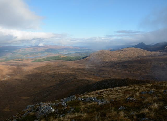
A rocky little peak above the head of Loch Arkaig, looking south into the wild emptiness of Glen Pean and west toward the Sgurr na Ciche range. The summit is awkward to reach without a bike: the loch road is one of the longest cul-de-sacs in Lochaber.
Quick facts
- Height
- 749m/ 2457ft
- Prominence
- 277 m
- Distance
- 14 km
- Ascent
- 614 m
- Time
- 4–7 hrs
- Grid ref
- NN127949
- Parking
- NM987916
- Nearest city
- Fort William· 21km
- Dogs
- Dogs on lead required near livestockDog-friendly guide ↗
Height and prominence cross-checked against the Database of British and Irish Hills (CC BY).
No GPX track yet
Walked this route? Share your track to help other walkers.
Standard route
loch-side track 30% · deep heather 40% · grassy upper slopes 20% · summit area 10%
Cycle or drive the full length of the Loch Arkaig road to Strathan, then walk west to Glen Pean Bothy area before ascending the steep south-east shoulder. Mixed grass and rock leads to a tiny rocky summit.
Terrain
Long loch-road drive, then a bothy track and finally trackless steep grass with broken rock above. Care choosing a line through the upper crags in mist.
In winter
Lochaber SAIS region applies — windslab can form on the north-east side after Atlantic frontal snow. Remoteness amplifies any winter mishap; very few people pass this way mid-week.
Best time of year
Getting there
- Glasgow3h 56m
- Edinburgh3h 11m
OS maps: OS Landranger 34
Mobile signal: Nothing in this remote Loch Arkaig/Glen Dessarry area
Current conditions
Daylight Today
- Sunrise
- 04:51
- Sunset
- 22:02
- Civil dawn
- 03:52
- Civil dusk
- 23:01
NOAA Solar Calculator · 17 July 2026
Pair with
Curated multi-hill combinations from Sgurr Choinnich (Sgurr Choinich).
On a long-distance route
Sgurr Choinnich (Sgurr Choinich) sits within 5km of these named long-distance walks — useful for trail-pack rest days or section extensions.
Around Sgurr Choinnich (Sgurr Choinich) on the SCOT network
Getting there, basing yourself, and what to do off the hill.
Getting there: Banavie station
Neptune's Staircase; alternate Fort William access; Great Glen Way
18km from the hill
tripscot.co.uk
On TripSCOTBase yourself in Fort William
Ben Nevis base, West Highland Line, gateway to Lochaber
21km from the hill
tripscot.co.uk
On TasteSCOTAfter the hill: Ben Nevis Distillery
Fort William — Lochaber distillery at the foot of the Ben; long-aged Japanese-owned classics
19km from the hill
tastescot.co.uk
Sgurr Choinnich (Sgurr Choinich) — common questions
- Is Sgurr Choinnich (Sgurr Choinich) a hard climb?
- Sgurr Choinnich (Sgurr Choinich) is rated 4/5 (challenging) on the OutdoorSCOT scale. The standard route covers about 14km with 614m of ascent and takes most walkers 4-7 hours. Underfoot: Long loch-road drive, then a bothy track and finally trackless steep grass with broken rock above.
- What is Sgurr Choinnich (Sgurr Choinich)'s prominence?
- 277m of prominence. That's the vertical drop from the summit to the col that links Sgurr Choinnich (Sgurr Choinich) to the next higher ground.
- Where do I park for Sgurr Choinnich (Sgurr Choinich)?
- Most walkers start from NM987916. Verify the grid reference on an OS map before you set off — space is tight on busy summer weekends.
- When is the best time to climb Sgurr Choinnich (Sgurr Choinich)?
- April, May, June, July, August, September, October give the most reliable conditions on Sgurr Choinnich (Sgurr Choinich). Beyond that window the high ground turns wintry: carry full mountain kit, be confident navigating, and check the SAIS avalanche forecast for the area.
- Is Sgurr Choinnich (Sgurr Choinich) dog-friendly?
- Yes, but dogs must be kept on a lead — there is livestock or ground-nesting bird interest on the route.
- Is there mobile signal on Sgurr Choinnich (Sgurr Choinich)?
- Nothing in this remote Loch Arkaig/Glen Dessarry area
- Is Sgurr Choinnich (Sgurr Choinich) safe in winter?
- Lochaber SAIS region applies — windslab can form on the north-east side after Atlantic frontal snow. Remoteness amplifies any winter mishap; very few people pass this way mid-week.
Get the OutdoorSCOT weekly
One email a week — new route, hill and bothy guides, seasonal conditions and the odd hard-won lesson. No spam, unsubscribe in one click.