Corbett · Knoydart
Beinn Bhan
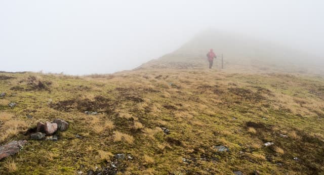
This Beinn Bhan — "white hill", distinct from the famous Applecross peak — is the 795m Corbett in the Lochaber country between Loch Arkaig and Loch Lochy. The summit is a trig point on a wide grassy dome with one of the broadest views in the area: the full sweep of the Loch Lochy Munros to the south, the Great Glen running east, and the western Knoydart-bound country stretching out to the west. With 495m of prominence the hill stands clear of its neighbours on all sides.
Gaelic: “mountain, fair” · Pronunciation: bine vahn
Quick facts
- Height
- 795.9m/ 2611ft
- Prominence
- 495 m
- Distance
- 14 km
- Ascent
- 652 m
- Time
- 4–7 hrs
- Grid ref
- NN140857
- Parking
- NN176888
- Nearest city
- Fort William· 12km
- Dogs
- Dogs on lead required near livestockDog-friendly guide ↗
Height and prominence cross-checked against the Database of British and Irish Hills (CC BY).
No GPX track yet
Walked this route? Share your track to help other walkers.
Standard route
forestry track 35% · open heather 30% · broad ridge 25% · trig summit 10%
Start from Clunes on the north shore of Loch Lochy and take the forestry track north up Gleann Cia-aig. After roughly 4km on the track, step off and leave the gravel and head north up heather and grass onto the broad south ridge of Beinn Bhan. The ridge gives a gentle pull to the trig summit. Around 14km return with 652m of ascent. Sometimes combined with Meall na h-Eilde for a long Loch Arkaig double.
Terrain
The Gleann Cia-aig forestry track is firm. Off the track the lower hill is bog and bracken; the upper slopes are short heather and grass — easy going with no path or technical ground. The summit dome is broad mossy ground with the trig pillar clearly visible. No exposure. Active forestry felling on the lower slopes occasionally diverts walkers; check entry signs.
In winter
A friendly winter day — gentle gradients, no avalanche concerns, with the broad summit dome holding snow well. The forestry track gives good shelter on the approach. Loch Lochy road and Clunes access are gritted and reliable in any conditions. Daylight short but the close approach makes the day manageable.
This hill is in the Glen Coe SAIS forecast area. Check SAIS forecasts in winter (December–April).
Best time of year
Getting there
- Glasgow3h 44m
- Edinburgh3h 2m
OS maps: OS Landranger 34, OS Landranger 41
Mobile signal: Intermittent at Clunes; nothing on the upper hill
Current conditions
Daylight Today
- Sunrise
- 04:45
- Sunset
- 22:06
- Civil dawn
- 03:45
- Civil dusk
- 23:07
NOAA Solar Calculator · 13 July 2026
Pair with
Curated multi-hill combinations from Beinn Bhan.
On a long-distance route
Beinn Bhan sits within 5km of these named long-distance walks — useful for trail-pack rest days or section extensions.
Around Beinn Bhan on the SCOT network
Getting there, basing yourself, and what to do off the hill.
Getting there: Banavie station
Neptune's Staircase; alternate Fort William access; Great Glen Way
9km from the hill
tripscot.co.uk
On TripSCOTBase yourself in Fort William
Ben Nevis base, West Highland Line, gateway to Lochaber
12km from the hill
tripscot.co.uk
On TasteSCOTAfter the hill: Ben Nevis Distillery
Fort William — Lochaber distillery at the foot of the Ben; long-aged Japanese-owned classics
10km from the hill
tastescot.co.uk
Beinn Bhan — common questions
- What difficulty is Beinn Bhan?
- On the OutdoorSCOT scale, Beinn Bhan comes in at 2/5 — moderate. Expect roughly 14km and 652m of ascent on the usual route — 4-7 hours for most parties. Underfoot: The Gleann Cia-aig forestry track is firm.
- What is Beinn Bhan's prominence?
- 495m of prominence. That's the vertical drop from the summit to the col that links Beinn Bhan to the next higher ground.
- Where do I park for Beinn Bhan?
- Most walkers start from NN176888. Verify the grid reference on an OS map before you set off — space is tight on busy summer weekends.
- When is the best time to climb Beinn Bhan?
- April, May, June, July, August, September, October give the most reliable conditions on Beinn Bhan. Beyond that window the high ground turns wintry: carry full mountain kit, be confident navigating, and check the SAIS avalanche forecast for the area.
- Is Beinn Bhan dog-friendly?
- Yes, but dogs must be kept on a lead — there is livestock or ground-nesting bird interest on the route.
- Is there mobile signal on Beinn Bhan?
- Intermittent at Clunes; nothing on the upper hill
- Is Beinn Bhan safe in winter?
- A friendly winter day — gentle gradients, no avalanche concerns, with the broad summit dome holding snow well. The forestry track gives good shelter on the approach. Loch Lochy road and Clunes access are gritted and reliable in any conditions. Daylight short but the close approach makes the day manageable.
Get the OutdoorSCOT weekly
One email a week — new route, hill and bothy guides, seasonal conditions and the odd hard-won lesson. No spam, unsubscribe in one click.