Corbett · Glen Garry
Geal Charn
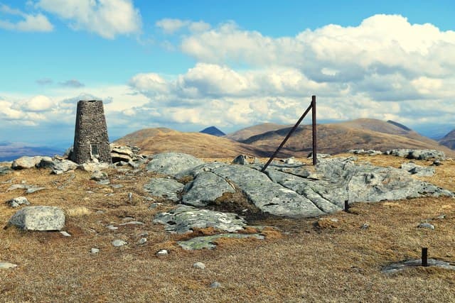
This Geal Charn — "white cairn", one of many across Scotland — is the 804m Corbett in the rough country north of Loch Arkaig between Glen Dessarry and the head of Loch Quoich. A concrete trig pillar stands on the broad grassy dome at the top, with pathless moor and scattered lochans stretching away on all sides. The hill sees few visitors compared to its more dramatic neighbours and offers a quiet alternative for those after empty Highland country with a good summit view.
Gaelic: “white, cairn-topped hill” · Pronunciation: gyal charn
Quick facts
- Height
- 804m/ 2638ft
- Prominence
- 156 m
- Distance
- 15 km
- Ascent
- 708 m
- Time
- 4–7 hrs
- Grid ref
- NN156942
- Parking
- NM987916
- Nearest city
- Fort William· 21km
- Dogs
- Dogs on lead required near livestockDog-friendly guide ↗
Height and prominence cross-checked against the Database of British and Irish Hills (CC BY).
No GPX track yet
Walked this route? Share your track to help other walkers.
Standard route
stalkers path 30% · rough heather 35% · broad ridge 25% · trig summit 10%
Begin at Strathan, the road end above Loch Arkaig's western tip, and walk in along the Glen Dessarry stalkers path. About 4km up the glen, peel off the path and push pathless north-west through heather onto the broad east ridge of Geal Charn. The ridge gives a steady pull to the trig summit. Around 15km return with 708m of ascent. Often combined with Sgurr Mhurlagain or Carn Mor for a long Loch Arkaig day.
Terrain
The Glen Dessarry stalkers path is firm gravel for the first few kilometres. Off the path the ground is rough heather and peat hag with no waymarks; the broad ridge is short grass and small rocks. The summit dome is featureless; the trig pillar is unmistakable in clear weather. No exposure or scrambling.
In winter
A long winter day, mostly because of the remote approach. The hill itself has gentle gradients and no avalanche risk. The Loch Arkaig road is single-track and ices over; in heavy snow the drive to Strathan can be slow. Phone signal is absent throughout the day.
Best time of year
Getting there
- Glasgow3h 54m
- Edinburgh3h 8m
OS maps: OS Landranger 34
Mobile signal: No signal in upper Loch Arkaig/Glen Dessarry area
Current conditions
Daylight Today
- Sunrise
- 04:45
- Sunset
- 22:07
- Civil dawn
- 03:44
- Civil dusk
- 23:08
NOAA Solar Calculator · 13 July 2026
Pair with
Curated multi-hill combinations from Geal Charn.
Around Geal Charn on the SCOT network
Getting there, basing yourself, and what to do off the hill.
Getting there: Roy Bridge station
Glen Roy; Grey Corries (Stob Choire Claurigh, Sgurr Choinnich Mor)
17km from the hill
tripscot.co.uk
On TripSCOTBase yourself in Fort William
Ben Nevis base, West Highland Line, gateway to Lochaber
21km from the hill
tripscot.co.uk
On TasteSCOTAfter the hill: Ben Nevis Distillery
Fort William — Lochaber distillery at the foot of the Ben; long-aged Japanese-owned classics
19km from the hill
tastescot.co.uk
Geal Charn — common questions
- How difficult is Geal Charn?
- Geal Charn carries a 3/5 (moderately challenging) grade on the OutdoorSCOT scale. Count on about 15km, 708m of ascent and a 4-7 hour day on the standard route. Underfoot: The Glen Dessarry stalkers path is firm gravel for the first few kilometres.
- What is Geal Charn's prominence?
- 156m of prominence. That's the vertical drop from the summit to the col that links Geal Charn to the next higher ground.
- Where do I park for Geal Charn?
- Most walkers start from NM987916. Verify the grid reference on an OS map before you set off — space is tight on busy summer weekends.
- When is the best time to climb Geal Charn?
- April, May, June, July, August, September, October give the most reliable conditions on Geal Charn. Beyond that window the high ground turns wintry: carry full mountain kit, be confident navigating, and check the SAIS avalanche forecast for the area.
- Is Geal Charn dog-friendly?
- Yes, but dogs must be kept on a lead — there is livestock or ground-nesting bird interest on the route.
- Is there mobile signal on Geal Charn?
- No signal in upper Loch Arkaig/Glen Dessarry area
- Is Geal Charn safe in winter?
- A long winter day, mostly because of the remote approach. The hill itself has gentle gradients and no avalanche risk. The Loch Arkaig road is single-track and ices over; in heavy snow the drive to Strathan can be slow. Phone signal is absent throughout the day.
Get the OutdoorSCOT weekly
One email a week — new route, hill and bothy guides, seasonal conditions and the odd hard-won lesson. No spam, unsubscribe in one click.