Corbett · Loch Arkaig
Carn Mor
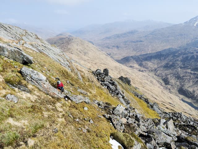
This Carn Mor — "big cairn", a common name shared by several Corbetts — is the 830m hill on the watershed between Loch Arkaig and Glen Pean, in the empty country north-east of the Rough Bounds. Open heather and small rocky outcrops dominate the slopes, and the summit cairn perches on a low rise above wide moorland. The view west into the Rough Bounds and south back over Loch Arkaig gives it more presence than the gentle terrain suggests.
Gaelic: “cairn-topped hill, big” · Pronunciation: karn more
Quick facts
- Height
- 830m/ 2723ft
- Prominence
- 614 m
- Distance
- ~15 km
- Ascent
- ~730 m
- Time
- 5–7 hrs
- Grid ref
- NM903909
- Parking
- NM987916
- Nearest city
- Fort William· 26km
- Dogs
- Dogs on lead required near livestockDog-friendly guide ↗
Height and prominence cross-checked against the Database of British and Irish Hills (CC BY).
No GPX track yet
Walked this route? Share your track to help other walkers.
Standard route
stalkers path 30% · bog and heather 40% · broad ridge 20% · summit cairn 10%
Start from the road end at Strathan at the head of Loch Arkaig and follow the stalkers path north toward Glen Pean for around 3km. Where the path forks, take the right branch heading north-east up the Allt Camgharaidh, then climb pathless heather slopes onto the broad south ridge of Carn Mor. Around 15km return with 730m of ascent. Often paired with the higher Corbett Sgurr Mhurlagain on the same side of Loch Arkaig for a longer Loch Arkaig day.
Terrain
The Glen Pean stalkers path holds up well for the opening miles. Off the path the Allt Camgharaidh side-glen is wet bog with patches of heather; slow, trackless ground. The summit area is broad short grass with the cairn on a low rise of small rocks. The west drop is steep into Glen Pean; navigation east in mist matters.
In winter
A long winter day mostly because of the approach distance and the absence of any phone signal across the upper Loch Arkaig area. The hill itself is benign — no avalanche slopes or cornices. The Loch Arkaig road can be slow to drive after heavy snow; it is single-track for its full length. Daylight is the main limiter; start early.
Kit for this: the winter Munro kit list · which boots take crampons
Best time of year
Getting there
- Glasgow3h 3m
- Edinburgh3h 26m
OS maps: OS Landranger 40, OS Explorer 390
Mobile signal: No signal at Strathan or beyond; Spean Bridge has reliable coverage
Current conditions
Daylight Today
- Sunrise
- 07:52
- Sunset
- 18:24
- Civil dawn
- 07:13
- Civil dusk
- 19:02
NOAA Solar Calculator · 14 October 2026
Around Carn Mor on the SCOT network
Getting there, basing yourself, and what to do off the hill.
Getting there: Glenfinnan station
Glenfinnan Viaduct; Streap, Sgurr Thuilm, Glen Finnan Munros
10km from the hill
tripscot.co.uk
On TripSCOTBase yourself in Mallaig
Ferry port for Skye and the Small Isles; CWT finish supply
23km from the hill
tripscot.co.uk
On TasteSCOTAfter the hill: Ben Nevis Distillery
Fort William — Lochaber distillery at the foot of the Ben; long-aged Japanese-owned classics
26km from the hill
tastescot.co.uk
Carn Mor — common questions
- How hard is Carn Mor?
- We grade Carn Mor at 3/5, which puts it in moderately challenging territory. The usual route is around 15km with 730m of climbing; allow 5-7 hours. Terrain: The Glen Pean stalkers path holds up well for the opening miles.
- How prominent is Carn Mor?
- Carn Mor has 614m of topographic prominence — the height of its summit above the highest col connecting it to higher ground.
- Where should I park to climb Carn Mor?
- Standard parking is at NM987916. Check the parking grid reference on an OS map before travel; informal laybys can fill on summer weekends.
- When should I climb Carn Mor?
- The standard good-weather months for Carn Mor are May, June, July, August, September. Outside those months, expect winter conditions on the high ground — full mountain kit, navigation skills, and a check of the SAIS avalanche forecast for the relevant region.
- Can I bring my dog up Carn Mor?
- On a lead only — the route crosses ground with livestock or nesting-bird interest.
- What's mobile reception like on Carn Mor?
- No signal at Strathan or beyond; Spean Bridge has reliable coverage
- Is Carn Mor safe in winter?
- A long winter day mostly because of the approach distance and the absence of any phone signal across the upper Loch Arkaig area. The hill itself is benign — no avalanche slopes or cornices. The Loch Arkaig road can be slow to drive after heavy snow; it is single-track for its full length. Daylight is the main limiter; start early.
Get the OutdoorSCOT weekly
One email a week — new route, hill and bothy guides, seasonal conditions and the odd hard-won lesson. No spam, unsubscribe in one click.