Corbett · Glenfinnan
Sgurr an Utha
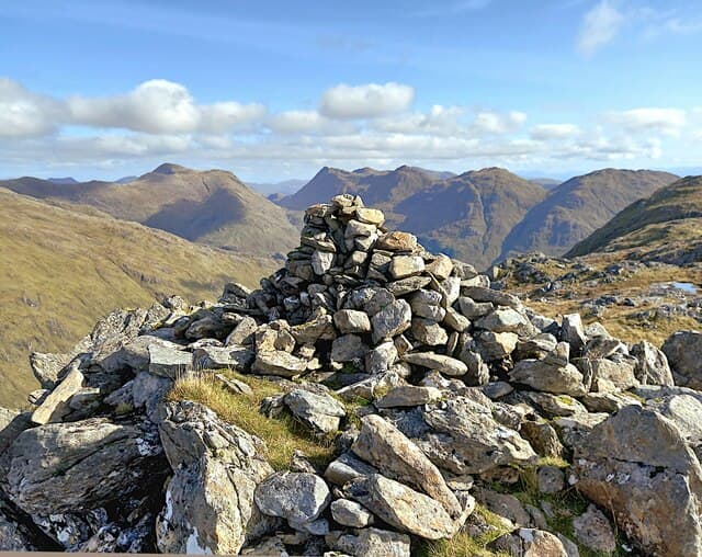
Sgurr an Utha — "peak of the udder", from the rounded twin-topped profile — rises directly above the A830 between Glenfinnan and Lochailort, looking down on Loch Eilt and the Jacobite steam train route. At 796m the summit is a small cairn on a rocky crest with one of the most accessible Lochaber views: Loch Eilt running west, the Glenfinnan Viaduct visible to the east, and the Rough Bounds beyond. With 499m of prominence the hill is freestanding from any near neighbour.
Quick facts
- Height
- 796m/ 2612ft
- Prominence
- 499 m
- Distance
- ~14 km
- Ascent
- ~653 m
- Time
- 4–7 hrs
- Grid ref
- NM885839
- Parking
- NM885847
- Nearest city
- Fort William· 24km
- Dogs
- Dogs on lead required near livestockDog-friendly guide ↗
Height and prominence cross-checked against the Database of British and Irish Hills (CC BY).
No GPX track yet
Walked this route? Share your track to help other walkers.
Standard route
forest track 25% · open heather 35% · broken ridge 30% · summit cairn 10%
Park at the lay-by on the A830 near Loch Eilt and follow the short stalkers track north into the forest. After leaving the trees, climb open grass and heather slopes north onto the south-east ridge of Sgurr an Utha. Steady climbing on the ridge reaches the summit cairn after one minor top. Around 14km return with 653m of ascent. The hill is easily reached by train from Glasgow on the West Highland Line; alight at Lochailort or Glenfinnan.
Terrain
The lower stalkers track is firm. Above the forest the hillside is open heather and short grass with no path; the climb is steady but never technical. The summit ridge is short rocky steps and turf with the cairn at the high point. No exposure or scrambling. The two minor tops between the path-end and the summit can confuse in mist.
In winter
A typical Lochaber Corbett in winter — the maritime position means snow cover is intermittent but the open ridge ices up readily. Avalanche risk minimal on the standard line. The A830 is gritted; West Highland Line trains generally run through most weather. Midwinter daylight is short, but the brief approach keeps a single hill within reach.
Kit for this: the winter Munro kit list · which boots take crampons
Best time of year
Getting there
- Glasgow3h 56m
- Edinburgh3h 23m
OS maps: OS Landranger 40
Mobile signal: Intermittent along the A830; nothing higher up
Current conditions
Daylight Today
- Sunrise
- 07:52
- Sunset
- 18:24
- Civil dawn
- 07:14
- Civil dusk
- 19:02
NOAA Solar Calculator · 14 October 2026
Pair with
Curated multi-hill combinations from Sgurr an Utha.
Around Sgurr an Utha on the SCOT network
Getting there, basing yourself, and what to do off the hill.
Base yourself in Fort William
Ben Nevis base, West Highland Line, gateway to Lochaber
24km from the hill
tripscot.co.uk
On TasteSCOTAfter the hill: Ben Nevis Distillery
Fort William — Lochaber distillery at the foot of the Ben; long-aged Japanese-owned classics
25km from the hill
tastescot.co.uk
Sgurr an Utha — common questions
- How difficult is Sgurr an Utha?
- Sgurr an Utha carries a 2/5 (moderate) grade on the OutdoorSCOT scale. Count on about 14km, 653m of ascent and a 4-7 hour day on the standard route. Ground conditions: The lower stalkers track is firm.
- How much drop does Sgurr an Utha have?
- The drop is 499m: measured from the summit of Sgurr an Utha down to the saddle joining it to higher terrain.
- Where's the parking for Sgurr an Utha?
- Park at NM885847. Double-check the grid reference on an OS map first; informal laybys here fill early in high season.
- What's the best month to climb Sgurr an Utha?
- Aim for May, June, July, August, September on Sgurr an Utha. In the remaining months treat it as a winter hill — full kit, solid navigation, and a look at the relevant SAIS avalanche forecast before you go.
- Can dogs go up Sgurr an Utha?
- Dogs are fine on a lead. The route passes livestock or ground-nesting bird habitat, so keep them close throughout.
- Will I get phone signal on Sgurr an Utha?
- Intermittent along the A830; nothing higher up
- Is Sgurr an Utha safe in winter?
- A typical Lochaber Corbett in winter — the maritime position means snow cover is intermittent but the open ridge ices up readily. Avalanche risk minimal on the standard line. The A830 is gritted; West Highland Line trains generally run through most weather. Midwinter daylight is short, but the brief approach keeps a single hill within reach.
Get the OutdoorSCOT weekly
One email a week — new route, hill and bothy guides, seasonal conditions and the odd hard-won lesson. No spam, unsubscribe in one click.