Corbett · Moidart
Beinn Odhar Bheag
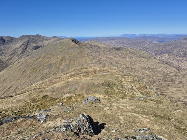
Beinn Odhar Bheag — "the little dun-coloured hill", despite being the higher of the Odhar twins — rises in stunning isolation between the head of Loch Shiel and the road from Lochailort to Glenfinnan. With well over 600m of prominence, this 883m Corbett is among the most genuinely freestanding peaks in the country; it stands alone from any near neighbour, hence its reputation as a fine mountain in miniature. The summit looks straight down 800m of crag and grass into Loch Shiel — one of the great viewpoints in the western Highlands.
Gaelic: “mountain, small” · Pronunciation: bine odhar vek
Quick facts
- Height
- 883.3m/ 2898ft
- Prominence
- 775 m
- Distance
- 16 km
- Ascent
- 777 m
- Time
- 5–8 hrs
- Grid ref
- NM846778
- Parking
- NM848823
- Nearest city
- Fort William· 26km
- Dogs
- Dogs on lead required near livestockDog-friendly guide ↗
Height and prominence cross-checked against the Database of British and Irish Hills (CC BY).
No GPX track yet
Walked this route? Share your track to help other walkers.
Standard route
woodland path 20% · heather hillside 45% · grassy upper slopes 25% · summit area 10%
The standard line starts from the lay-by at Polnish on the A830 west of Glenfinnan, climbing the steep south ridge of Beinn Mhic Cedidh first and then traversing east over Beinn Odhar Mhor to Beinn Odhar Bheag. Around 16km return with 777m of ascent. The traverse is sustained, with several steep grass-and-rock pulls and dramatic positions overlooking Loch Shiel. Return retraces the line; descents to the south or east are not viable due to crag bands.
Terrain
Lower slopes from Polnish are wet rough grass and bracken with intermittent path. Above the heather line the ground turns to steep grass with rocky steps; one section requires hand contact with rock on the south ridge of Beinn Mhic Cedidh. The traverse to Beinn Odhar Mhor involves a noticeable dip and re-ascent on grass. The final summit dome of Beinn Odhar Bheag is narrow with significant exposure to the east overlooking Loch Shiel.
In winter
In winter the ridge becomes a serious mountaineering objective despite its modest altitude — the south face of Beinn Mhic Cedidh is a recognised avalanche slope after westerly storms, and the narrow east-facing summit ridge of Beinn Odhar Bheag develops cornices. The grass slopes ice up faster than the height would suggest. Most parties save this hill for late spring; full winter ascents need experience and stable conditions.
This hill is in the Glen Coe SAIS forecast area. Check SAIS forecasts in winter (December–April).
Best time of year
Getting there
- Glasgow3h 52m
- Edinburgh3h 22m
OS maps: OS Landranger 40
Mobile signal: No signal on this remote Moidart hill
Current conditions
Daylight Today
- Sunrise
- 04:48
- Sunset
- 22:08
- Civil dawn
- 03:48
- Civil dusk
- 23:08
NOAA Solar Calculator · 13 July 2026
Pair with
Curated multi-hill combinations from Beinn Odhar Bheag.
Around Beinn Odhar Bheag on the SCOT network
Getting there, basing yourself, and what to do off the hill.
Getting there: Glenfinnan station
Glenfinnan Viaduct; Streap, Sgurr Thuilm, Glen Finnan Munros
7km from the hill
tripscot.co.uk
On TripSCOTBase yourself in Mallaig
Ferry port for Skye and the Small Isles; CWT finish supply
25km from the hill
tripscot.co.uk
On TasteSCOTAfter the hill: Ben Nevis Distillery
Fort William — Lochaber distillery at the foot of the Ben; long-aged Japanese-owned classics
27km from the hill
tastescot.co.uk
Beinn Odhar Bheag — common questions
- Is Beinn Odhar Bheag a hard climb?
- Beinn Odhar Bheag is rated 4/5 (challenging) on the OutdoorSCOT scale. The standard route covers about 16km with 777m of ascent and takes most walkers 5-8 hours. Terrain: Lower slopes from Polnish are wet rough grass and bracken with intermittent path.
- How prominent is Beinn Odhar Bheag?
- Beinn Odhar Bheag has 775m of topographic prominence — the height of its summit above the highest col connecting it to higher ground.
- Where should I park to climb Beinn Odhar Bheag?
- Standard parking is at NM848823. Check the parking grid reference on an OS map before travel; informal laybys can fill on summer weekends.
- When should I climb Beinn Odhar Bheag?
- The standard good-weather months for Beinn Odhar Bheag are May, June, July, August, September. Outside those months, expect winter conditions on the high ground — full mountain kit, navigation skills, and a check of the SAIS avalanche forecast for the relevant region.
- Can I bring my dog up Beinn Odhar Bheag?
- On a lead only — the route crosses ground with livestock or nesting-bird interest.
- What's mobile reception like on Beinn Odhar Bheag?
- No signal on this remote Moidart hill
- Is Beinn Odhar Bheag safe in winter?
- In winter the ridge becomes a serious mountaineering objective despite its modest altitude — the south face of Beinn Mhic Cedidh is a recognised avalanche slope after westerly storms, and the narrow east-facing summit ridge of Beinn Odhar Bheag develops cornices. The grass slopes ice up faster than the height would suggest. Most parties save this hill for late spring; full winter ascents need experience and stable conditions.
Get the OutdoorSCOT weekly
One email a week — new route, hill and bothy guides, seasonal conditions and the odd hard-won lesson. No spam, unsubscribe in one click.