Corbett · Moidart
Beinn Mhic Cedidh
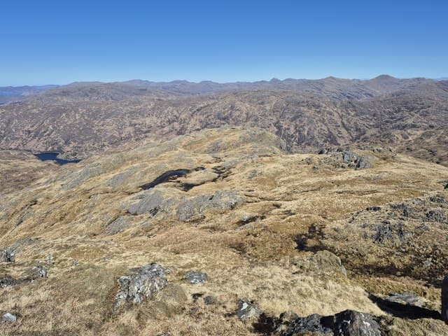
Beinn Mhic Cedidh is the easternmost summit of the Rois-bheinn ridge in Moidart, the 783m Corbett looking south-east across Glen Aladale toward the Glenfinnan Monument. The mountain forms the natural pair with Sgùrr na Bà Glaise on the four-Corbett Moidart traverse, and is most often climbed as part of that classic ridge round. The summit gives a striking view down toward Loch Shiel and across to Sgùrr Ghiubhsachain.
Gaelic: “mountain, son of” · Pronunciation: bine mhic cedidh
Quick facts
- Height
- 783m/ 2569ft
- Prominence
- 296 m
- Distance
- 13 km
- Ascent
- 850 m
- Time
- 4–6 hrs
- Grid ref
- NM828788
- Parking
- NM767812
- Nearest city
- Fort William· 28km
- Dogs
- Dogs on lead required near livestockDog-friendly guide ↗
Height and prominence cross-checked against the Database of British and Irish Hills (CC BY).
No GPX track yet
Walked this route? Share your track to help other walkers.
Standard route
glen path 20% · heather hillside 50% · grassy upper slopes 20% · summit area 10%
From the Inversilort parking on the A861 (NM767812), follow the path north-east up Coire a' Bhuiridh and onto the Rois-bheinn ridge. Beinn Mhic Cedidh sits at the east end of the ridge — most efficiently climbed last on the classic four-Corbett traverse of the Moidart skyline. Descent from Mhic Cedidh drops south to Inversilort. Allow 9–10 hours for the full traverse; 6–7 hours for Beinn Mhic Cedidh alone via the south ridge.
Terrain
Bracken and grass on the lower slopes — slow in summer growth. The Rois-bheinn ridge is dry rock and grass with a sense of exposure on the connecting cols. The summit area of Beinn Mhic Cedidh is broad and grassy with a small cairn. The east descent line is steep and slippery in wet.
In winter
Maritime Moidart winter — snow is intermittent on the moderate elevation, but Atlantic systems can turn the ridge into a committed place under any cover. The Rois-bheinn traverse becomes a major mountaineering day in firm winter conditions; for a single hill, Beinn Mhic Cedidh alone is manageable. The Lochailort area road is reliably ploughed.
This hill is in the Glen Coe SAIS forecast area. Check SAIS forecasts in winter (December–April).
Best time of year
Getting there
- Glasgow3h 54m
- Edinburgh3h 24m
OS maps: OS Landranger 40
Mobile signal: No signal in South Moidart area
Current conditions
Daylight Today
- Sunrise
- 04:54
- Sunset
- 22:03
- Civil dawn
- 03:56
- Civil dusk
- 23:01
NOAA Solar Calculator · 17 July 2026
Pair with
Curated multi-hill combinations from Beinn Mhic Cedidh.
Around Beinn Mhic Cedidh on the SCOT network
Getting there, basing yourself, and what to do off the hill.
Getting there: Glenfinnan station
Glenfinnan Viaduct; Streap, Sgurr Thuilm, Glen Finnan Munros
8km from the hill
tripscot.co.uk
On TripSCOTBase yourself in Mallaig
Ferry port for Skye and the Small Isles; CWT finish supply
23km from the hill
tripscot.co.uk
On TasteSCOTAfter the hill: Ben Nevis Distillery
Fort William — Lochaber distillery at the foot of the Ben; long-aged Japanese-owned classics
29km from the hill
tastescot.co.uk
Beinn Mhic Cedidh — common questions
- How difficult is Beinn Mhic Cedidh?
- Beinn Mhic Cedidh carries a 3/5 (moderately challenging) grade on the OutdoorSCOT scale. Count on about 13km, 850m of ascent and a 4-6 hour day on the standard route. Underfoot: Bracken and grass on the lower slopes — slow in summer growth.
- What is Beinn Mhic Cedidh's prominence?
- 296m of prominence. That's the vertical drop from the summit to the col that links Beinn Mhic Cedidh to the next higher ground.
- Where do I park for Beinn Mhic Cedidh?
- Most walkers start from NM767812. Verify the grid reference on an OS map before you set off — space is tight on busy summer weekends.
- When is the best time to climb Beinn Mhic Cedidh?
- May, June, July, August, September give the most reliable conditions on Beinn Mhic Cedidh. Beyond that window the high ground turns wintry: carry full mountain kit, be confident navigating, and check the SAIS avalanche forecast for the area.
- Is Beinn Mhic Cedidh dog-friendly?
- Yes, but dogs must be kept on a lead — there is livestock or ground-nesting bird interest on the route.
- Is there mobile signal on Beinn Mhic Cedidh?
- No signal in South Moidart area
- Is Beinn Mhic Cedidh safe in winter?
- Maritime Moidart winter — snow is intermittent on the moderate elevation, but Atlantic systems can turn the ridge into a committed place under any cover. The Rois-bheinn traverse becomes a major mountaineering day in firm winter conditions; for a single hill, Beinn Mhic Cedidh alone is manageable. The Lochailort area road is reliably ploughed.
Get the OutdoorSCOT weekly
One email a week — new route, hill and bothy guides, seasonal conditions and the odd hard-won lesson. No spam, unsubscribe in one click.