Graham · Glen Coe & Lochaber
Croit Bheinn
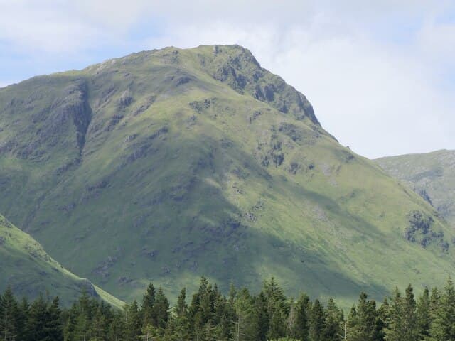
Croit Bheinn (664m) — the hill of the croft — is a quiet Moidart summit in the NM87 square, set on the north side of Glen Aladale between Glenfinnan and Loch Shiel. The small cairn looks south down Loch Shiel to the volcanic plug of Ben Hiant in Ardnamurchan and north over the Glenfinnan Munros. Pathless throughout, this is a hill for connoisseurs of the lonely.
Quick facts
- Height
- 664.5m/ 2180ft
- Prominence
- 228 m
- Distance
- 13 km
- Ascent
- 544 m
- Time
- 4–6 hrs
- Grid ref
- NM810773
- Parking
- NM805764
- Nearest city
- Fort William· 30km
- Dogs
- Dogs on lead required near livestockDog-friendly guide ↗
Height and prominence cross-checked against the Database of British and Irish Hills (CC BY).
No GPX track yet
Walked this route? Share your track to help other walkers.
Standard route
heather and bog 65% · grass slopes 20% · rocky outcrops 15%
Park beside the A861 at Polloch and follow the rough estate path up Glen Aladale for several kilometres. Cross the burn where it forks and climb the steep south-west spur on bracken and tussock. The angle eases onto a broad heather ridge that leads gently to the cairn — a long approach for a modest summit, but the silence is the reward.
Terrain
Faint estate path in the glen for the first few kilometres, then bracken and tussock on the open hillside. The south-west spur is the steepest part; above it the broad heather ridge is gentle but boggy in patches. The cairn is small and easy to miss in mist.
In winter
Moidart sees more rain than snow but cold snaps glaze the bracken slopes with treacherous ice. Croit Bheinn's broad north-east flank holds drifted snow into late spring. The remoteness amplifies any incident — phone signal is non-existent and self-rescue is the realistic plan.
This hill is in the Glen Coe SAIS forecast area. Check SAIS forecasts in winter (December–April).
Best time of year
Getting there
- Glasgow3h 54m
- Edinburgh3h 25m
OS maps: OS Landranger 40
Mobile signal: Poor. Remote Moidart/Ardnamurchan area; limited coverage.
Current conditions
Daylight Today
- Sunrise
- 04:48
- Sunset
- 22:08
- Civil dawn
- 03:48
- Civil dusk
- 23:08
NOAA Solar Calculator · 13 July 2026
Around Croit Bheinn on the SCOT network
Getting there, basing yourself, and what to do off the hill.
Croit Bheinn — common questions
- How difficult is Croit Bheinn?
- Croit Bheinn carries a 4/5 (challenging) grade on the OutdoorSCOT scale. Count on about 13km, 544m of ascent and a 4-6 hour day on the standard route. Terrain: Faint estate path in the glen for the first few kilometres, then bracken and tussock on the open hillside.
- How prominent is Croit Bheinn?
- Croit Bheinn has 228m of topographic prominence — the height of its summit above the highest col connecting it to higher ground.
- Where should I park to climb Croit Bheinn?
- Standard parking is at NM805764. Check the parking grid reference on an OS map before travel; informal laybys can fill on summer weekends.
- When should I climb Croit Bheinn?
- The standard good-weather months for Croit Bheinn are May, June, July, August, September. Outside those months, expect winter conditions on the high ground — full mountain kit, navigation skills, and a check of the SAIS avalanche forecast for the relevant region.
- Can I bring my dog up Croit Bheinn?
- On a lead only — the route crosses ground with livestock or nesting-bird interest.
- What's mobile reception like on Croit Bheinn?
- Poor. Remote Moidart/Ardnamurchan area; limited coverage.
- Is Croit Bheinn safe in winter?
- Moidart sees more rain than snow but cold snaps glaze the bracken slopes with treacherous ice. Croit Bheinn's broad north-east flank holds drifted snow into late spring. The remoteness amplifies any incident — phone signal is non-existent and self-rescue is the realistic plan.
Get the OutdoorSCOT weekly
One email a week — new route, hill and bothy guides, seasonal conditions and the odd hard-won lesson. No spam, unsubscribe in one click.