Graham · Glen Coe & Lochaber
Meall nan Damh
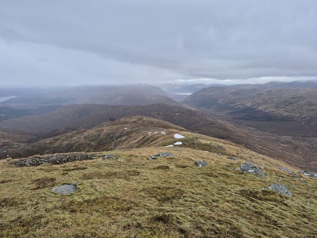
A remote heathery Graham in the wild country south of Loch Shiel, between Polloch and Glenfinnan. Reached by a long forest road approach with the West Highland Line for company.
Gaelic: “rounded hill, of the, stag” · Pronunciation: myowl nan dav
Quick facts
- Height
- 723.4m/ 2373ft
- Prominence
- 344 m
- Distance
- 13 km
- Ascent
- 593 m
- Time
- 4–6 hrs
- Grid ref
- NM919744
- Parking
- NM900747
- Nearest city
- Fort William· 19km
- Dogs
- Dogs on lead required near livestockDog-friendly guide ↗
Height and prominence cross-checked against the Database of British and Irish Hills (CC BY).
No GPX track yet
Walked this route? Share your track to help other walkers.
Standard route
loch-side path 20% · heather hillside 45% · grassy ridge 25% · summit area 10%
Start at Polloch on the south side of Loch Shiel. Follow the forest road south-west into the upper Polloch glen, then leave the track and climb the north-east ridge through young plantation onto the heather summit.
Terrain
Forest road, then rough plantation and felled blocks. Above the treeline, deep heather and small lochans. No path of any kind on the upper hill.
In winter
Maritime west-coast snow — wet, sticky and short-lived. The Polloch forest road can be blocked by windblown trees after winter storms. Daylight is the main constraint.
This hill is in the Glen Coe SAIS forecast area. Check SAIS forecasts in winter (December–April).
Best time of year
Getting there
- Glasgow3h 43m
- Edinburgh3h 13m
OS maps: OS Landranger 40
Mobile signal: No signal at Polloch or beyond
Current conditions
Daylight Today
- Sunrise
- 04:48
- Sunset
- 22:07
- Civil dawn
- 03:47
- Civil dusk
- 23:07
NOAA Solar Calculator · 13 July 2026
Around Meall nan Damh on the SCOT network
Getting there, basing yourself, and what to do off the hill.
Getting there: Glenfinnan station
Glenfinnan Viaduct; Streap, Sgurr Thuilm, Glen Finnan Munros
6km from the hill
tripscot.co.uk
On TripSCOTBase yourself in Fort William
Ben Nevis base, West Highland Line, gateway to Lochaber
19km from the hill
tripscot.co.uk
On TasteSCOTAfter the hill: Ben Nevis Distillery
Fort William — Lochaber distillery at the foot of the Ben; long-aged Japanese-owned classics
20km from the hill
tastescot.co.uk
Meall nan Damh — common questions
- What difficulty is Meall nan Damh?
- On the OutdoorSCOT scale, Meall nan Damh comes in at 4/5 — challenging. Expect roughly 13km and 593m of ascent on the usual route — 4-6 hours for most parties. Terrain: Forest road, then rough plantation and felled blocks.
- How prominent is Meall nan Damh?
- Meall nan Damh has 344m of topographic prominence — the height of its summit above the highest col connecting it to higher ground.
- Where should I park to climb Meall nan Damh?
- Standard parking is at NM900747. Check the parking grid reference on an OS map before travel; informal laybys can fill on summer weekends.
- When should I climb Meall nan Damh?
- The standard good-weather months for Meall nan Damh are May, June, July, August, September. Outside those months, expect winter conditions on the high ground — full mountain kit, navigation skills, and a check of the SAIS avalanche forecast for the relevant region.
- Can I bring my dog up Meall nan Damh?
- On a lead only — the route crosses ground with livestock or nesting-bird interest.
- What's mobile reception like on Meall nan Damh?
- No signal at Polloch or beyond
- Is Meall nan Damh safe in winter?
- Maritime west-coast snow — wet, sticky and short-lived. The Polloch forest road can be blocked by windblown trees after winter storms. Daylight is the main constraint.
Get the OutdoorSCOT weekly
One email a week — new route, hill and bothy guides, seasonal conditions and the odd hard-won lesson. No spam, unsubscribe in one click.