Graham · Glen Coe & Lochaber
Stob Mhic Bheathain
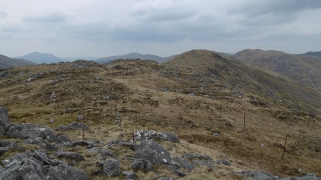
A craggy Graham on the spine of the Sunart-Moidart ridge between Strontian and Glenfinnan, near the higher Corbett Sgurr Dhomhnuill. The summit gives a striking view down Loch Shiel. Glen Coe and Lochaber top at 721 m — 13 km out and back, 591 m of climbing.
Gaelic: “pointed peak, son of” · Pronunciation: stob mhic bheathain
Quick facts
- Height
- 721m/ 2365ft
- Prominence
- 215 m
- Distance
- 13 km
- Ascent
- 591 m
- Time
- 4–6 hrs
- Grid ref
- NM914713
- Parking
- NM895720
- Nearest city
- Fort William· 19km
- Dogs
- Dogs on lead required near livestockDog-friendly guide ↗
Height and prominence cross-checked against the Database of British and Irish Hills (CC BY).
No GPX track yet
Walked this route? Share your track to help other walkers.
Standard route
moorland path 20% · heather hillside 50% · grassy upper slopes 20% · summit area 10%
Approach from the Strontian-Polloch road by the old lead mine track at Bellsgrove. Climb steeply north up Glen Sgurra onto the bealach east of Sgurr Dhomhnuill, then turn east along the ridge to Stob Mhic Bheathain.
Terrain
Old mine track, then steep heather and broken rock. The ridge is narrow in places with small scrambly steps. The summit cairn perches on the edge of the north face.
In winter
The narrow connecting ridge takes on a proper mountaineering feel under snow. Lochaber SAIS region applies — the north-facing corries hold significant avalanche risk despite the modest altitude.
This hill is in the Glen Coe SAIS forecast area. Check SAIS forecasts in winter (December–April).
Best time of year
Getting there
- Glasgow3h 40m
- Edinburgh3h 11m
OS maps: OS Landranger 40
Mobile signal: No signal in Glen Sgurra or on the ridge
Current conditions
Daylight Today
- Sunrise
- 04:54
- Sunset
- 22:02
- Civil dawn
- 03:56
- Civil dusk
- 23:00
NOAA Solar Calculator · 17 July 2026
Around Stob Mhic Bheathain on the SCOT network
Getting there, basing yourself, and what to do off the hill.
Getting there: Glenfinnan station
Glenfinnan Viaduct; Streap, Sgurr Thuilm, Glen Finnan Munros
9km from the hill
tripscot.co.uk
On TripSCOTBase yourself in Fort William
Ben Nevis base, West Highland Line, gateway to Lochaber
19km from the hill
tripscot.co.uk
On TasteSCOTAfter the hill: Ben Nevis Distillery
Fort William — Lochaber distillery at the foot of the Ben; long-aged Japanese-owned classics
21km from the hill
tastescot.co.uk
Stob Mhic Bheathain — common questions
- How hard is Stob Mhic Bheathain?
- We grade Stob Mhic Bheathain at 4/5, which puts it in challenging territory. The usual route is around 13km with 591m of climbing; allow 4-6 hours. Ground conditions: Old mine track, then steep heather and broken rock.
- How much drop does Stob Mhic Bheathain have?
- The drop is 215m: measured from the summit of Stob Mhic Bheathain down to the saddle joining it to higher terrain.
- Where's the parking for Stob Mhic Bheathain?
- Park at NM895720. Double-check the grid reference on an OS map first; informal laybys here fill early in high season.
- What's the best month to climb Stob Mhic Bheathain?
- Aim for May, June, July, August, September on Stob Mhic Bheathain. In the remaining months treat it as a winter hill — full kit, solid navigation, and a look at the relevant SAIS avalanche forecast before you go.
- Can dogs go up Stob Mhic Bheathain?
- Dogs are fine on a lead. The route passes livestock or ground-nesting bird habitat, so keep them close throughout.
- Will I get phone signal on Stob Mhic Bheathain?
- No signal in Glen Sgurra or on the ridge
- Is Stob Mhic Bheathain safe in winter?
- The narrow connecting ridge takes on a proper mountaineering feel under snow. Lochaber SAIS region applies — the north-facing corries hold significant avalanche risk despite the modest altitude.
Get the OutdoorSCOT weekly
One email a week — new route, hill and bothy guides, seasonal conditions and the odd hard-won lesson. No spam, unsubscribe in one click.