Corbett · Moidart
Carn na Nathrach
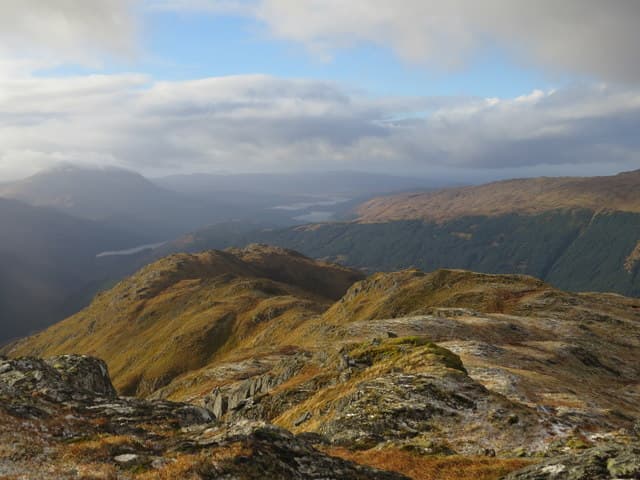
Carn na Nathrach — "cairn of the serpent" — is a quiet 786m Corbett deep in the Ardgour hills, between Glen Hurich and Glen Scaddle. A 382m prominence and remote setting in a corner of Lochaber rarely visited by hill-walkers gives the hill genuine solitude. The summit is a small cairn on a rocky top with views west into the Sunart and Moidart peninsulas and east across Loch Linnhe to the busier hills of mainland Lochaber.
Quick facts
- Height
- 786m/ 2579ft
- Prominence
- 382 m
- Distance
- 14 km
- Ascent
- 645 m
- Time
- 4–7 hrs
- Grid ref
- NM886698
- Parking
- NM832638
- Nearest city
- Fort William· 22km
- Dogs
- Dogs on lead required near livestockDog-friendly guide ↗
Height and prominence cross-checked against the Database of British and Irish Hills (CC BY).
No GPX track yet
Walked this route? Share your track to help other walkers.
Standard route
forestry track 40% · rough heather 30% · grassy ridge 20% · rocky top 10%
Start from the small road end at Sallachan on the A861 west of the Corran ferry, and walk in along the long forestry track up Glen Hurich for around 6km. Where the track ends near Resourie, pull up pathless heather to the south, gaining the broad north ridge of Carn na Nathrach. Around 14km return with 645m of ascent. Sometimes combined with the higher Corbett Sgurr Dhomhnuill for a long Ardgour day, though that involves significant re-ascent.
Terrain
The Glen Hurich forestry track is firm and clear. Beyond it the slopes are rough heather and bracken — pathless, slow going on the lower flanks. The broad north ridge above is short heather and grass with scattered crag bands easily avoided on the east side. The summit area is a compact rocky top. No exposure on the standard line.
In winter
A serious-feeling remote winter day rather than a technically challenging one. The Glen Hurich track gives some shelter on the approach; the open ridge is exposed to full Atlantic weather. No avalanche slopes on the standard line. The A861 around the Corran peninsula is generally clear; the Corran ferry can be cancelled in storms.
This hill is in the Glen Coe SAIS forecast area. Check SAIS forecasts in winter (December–April).
Best time of year
Getting there
- Glasgow3h 41m
- Edinburgh3h 13m
OS maps: OS Landranger 40
Mobile signal: No signal in interior Ardgour; intermittent at Sallachan
Current conditions
Daylight Today
- Sunrise
- 04:48
- Sunset
- 22:07
- Civil dawn
- 03:48
- Civil dusk
- 23:07
NOAA Solar Calculator · 13 July 2026
Around Carn na Nathrach on the SCOT network
Getting there, basing yourself, and what to do off the hill.
Getting there: Glenfinnan station
Glenfinnan Viaduct; Streap, Sgurr Thuilm, Glen Finnan Munros
11km from the hill
tripscot.co.uk
On TripSCOTBase yourself in Fort William
Ben Nevis base, West Highland Line, gateway to Lochaber
22km from the hill
tripscot.co.uk
On TasteSCOTAfter the hill: Ben Nevis Distillery
Fort William — Lochaber distillery at the foot of the Ben; long-aged Japanese-owned classics
24km from the hill
tastescot.co.uk
Carn na Nathrach — common questions
- What difficulty is Carn na Nathrach?
- On the OutdoorSCOT scale, Carn na Nathrach comes in at 2/5 — moderate. Expect roughly 14km and 645m of ascent on the usual route — 4-7 hours for most parties. Underfoot: The Glen Hurich forestry track is firm and clear.
- What is Carn na Nathrach's prominence?
- 382m of prominence. That's the vertical drop from the summit to the col that links Carn na Nathrach to the next higher ground.
- Where do I park for Carn na Nathrach?
- Most walkers start from NM832638. Verify the grid reference on an OS map before you set off — space is tight on busy summer weekends.
- When is the best time to climb Carn na Nathrach?
- May, June, July, August, September give the most reliable conditions on Carn na Nathrach. Beyond that window the high ground turns wintry: carry full mountain kit, be confident navigating, and check the SAIS avalanche forecast for the area.
- Is Carn na Nathrach dog-friendly?
- Yes, but dogs must be kept on a lead — there is livestock or ground-nesting bird interest on the route.
- Is there mobile signal on Carn na Nathrach?
- No signal in interior Ardgour; intermittent at Sallachan
- Is Carn na Nathrach safe in winter?
- A serious-feeling remote winter day rather than a technically challenging one. The Glen Hurich track gives some shelter on the approach; the open ridge is exposed to full Atlantic weather. No avalanche slopes on the standard line. The A861 around the Corran peninsula is generally clear; the Corran ferry can be cancelled in storms.
Get the OutdoorSCOT weekly
One email a week — new route, hill and bothy guides, seasonal conditions and the odd hard-won lesson. No spam, unsubscribe in one click.