Graham · Glen Coe & Lochaber
Sgurr nan Cnamh
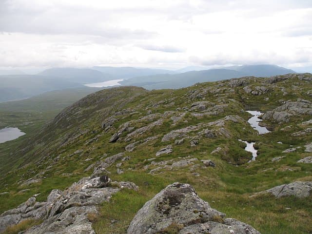
Sgurr nan Cnamh (701m) is a steep little peak above Loch Sunart in the NM88 square, set in the rough country south of Strontian. The name translates as peak of the bones — local lore links it to a deer-graveyard in its corrie. Its position between Beinn Resipol and Garbh Bheinn gives an unusually wide view of the Sound of Mull and the Morvern hills.
Quick facts
- Height
- 701.8m/ 2302ft
- Prominence
- 160 m
- Distance
- 13 km
- Ascent
- 575 m
- Time
- 4–6 hrs
- Grid ref
- NM886643
- Parking
- NM894632
- Nearest city
- Fort William· 24km
- Dogs
- Dogs on lead required near livestockDog-friendly guide ↗
Height and prominence cross-checked against the Database of British and Irish Hills (CC BY).
No GPX track yet
Walked this route? Share your track to help other walkers.
Standard route
heather moorland 60% · rocky slopes 25% · bog and wet grass 15%
From the parking pull-in west of Resipol Farm follow the rough track up the Allt Mhic Chiarain for around 2km, then leave it on a deer trail climbing east toward the bealach below the north ridge. The ridge proper is a delightful narrow crest of mica schist, with one easy scrambly notch before the cairn. Descend the south-east shoulder back to the loch road.
Terrain
Boggy approach through bracken and birch, with the going improving sharply at 350m onto firm schist and short cropped turf. The summit ridge is narrow but never seriously exposed, with one airy step at the notch. Two small lochans below the bealach make useful navigation handrails.
In winter
Sunart winters are mild and wet, but when arctic air does push west the schist ridge ices up quickly and the notch on the north ridge becomes the crux. Avalanche risk is low given the small scale, but the loch-shore approach can be windswept and exposed. SAIS Glen Coe forecasts give a usable proxy.
This hill is in the Glen Coe SAIS forecast area. Check SAIS forecasts in winter (December–April).
Best time of year
Getting there
- Glasgow3h 35m
- Edinburgh3h 9m
OS maps: OS Landranger 40
Mobile signal: Poor. Remote Glenelg area; signal weak even on summit.
Current conditions
Daylight Today
- Sunrise
- 04:55
- Sunset
- 22:01
- Civil dawn
- 03:57
- Civil dusk
- 22:59
NOAA Solar Calculator · 17 July 2026
Around Sgurr nan Cnamh on the SCOT network
Getting there, basing yourself, and what to do off the hill.
Getting there: Glenfinnan station
Glenfinnan Viaduct; Streap, Sgurr Thuilm, Glen Finnan Munros
16km from the hill
tripscot.co.uk
On TripSCOTBase yourself in Fort William
Ben Nevis base, West Highland Line, gateway to Lochaber
24km from the hill
tripscot.co.uk
On TasteSCOTAfter the hill: Ben Nevis Distillery
Fort William — Lochaber distillery at the foot of the Ben; long-aged Japanese-owned classics
26km from the hill
tastescot.co.uk
Sgurr nan Cnamh — common questions
- How hard is Sgurr nan Cnamh?
- We grade Sgurr nan Cnamh at 4/5, which puts it in challenging territory. The usual route is around 13km with 575m of climbing; allow 4-6 hours. Terrain: Boggy approach through bracken and birch, with the going improving sharply at 350m onto firm schist and short cropped turf.
- How prominent is Sgurr nan Cnamh?
- Sgurr nan Cnamh has 160m of topographic prominence — the height of its summit above the highest col connecting it to higher ground.
- Where should I park to climb Sgurr nan Cnamh?
- Standard parking is at NM894632. Check the parking grid reference on an OS map before travel; informal laybys can fill on summer weekends.
- When should I climb Sgurr nan Cnamh?
- The standard good-weather months for Sgurr nan Cnamh are May, June, July, August, September. Outside those months, expect winter conditions on the high ground — full mountain kit, navigation skills, and a check of the SAIS avalanche forecast for the relevant region.
- Can I bring my dog up Sgurr nan Cnamh?
- On a lead only — the route crosses ground with livestock or nesting-bird interest.
- What's mobile reception like on Sgurr nan Cnamh?
- Poor. Remote Glenelg area; signal weak even on summit.
- Is Sgurr nan Cnamh safe in winter?
- Sunart winters are mild and wet, but when arctic air does push west the schist ridge ices up quickly and the notch on the north ridge becomes the crux. Avalanche risk is low given the small scale, but the loch-shore approach can be windswept and exposed. SAIS Glen Coe forecasts give a usable proxy.
Get the OutdoorSCOT weekly
One email a week — new route, hill and bothy guides, seasonal conditions and the odd hard-won lesson. No spam, unsubscribe in one click.