Graham · Glen Coe & Lochaber
Sgorr Mhic Eacharna
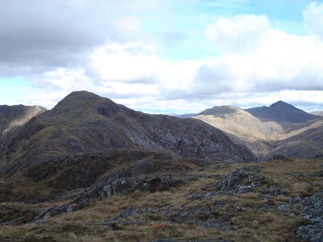
Sgorr Mhic Eacharna (650m) is an Ardgour outlier in the NM92 square above Strontian, looking across to Beinn Resipol and out over Loch Sunart. The cairn sits on a sharp shoulder of granite-veined schist with the Sound of Mull stretching south on a clear day.
Gaelic: “sharp peak, son of” · Pronunciation: skor mhic eacharna
Quick facts
- Height
- 650.5m/ 2134ft
- Prominence
- 169 m
- Distance
- 12 km
- Ascent
- 488 m
- Time
- 3–5 hrs
- Grid ref
- NM928630
- Parking
- NM814617
- Nearest city
- Fort William· 21km
- Dogs
- Dogs on lead required near livestockDog-friendly guide ↗
Height and prominence cross-checked against the Database of British and Irish Hills (CC BY).
No GPX track yet
Walked this route? Share your track to help other walkers.
Standard route
heather moorland 55% · rocky hillside 30% · grass and bog 15%
From the Strontian visitor car park, take the minor road north-west to the old lead mines at Bellsgrove. A stalker's path climbs north past the workings, then breaks east onto open ground. Pick up the south-east spur and follow it on grass and outcrop to the cairn — the line is more obvious than the map suggests.
Terrain
Tarred road and mine track first, then a clear stalker's path that fades on the open hillside. The shoulder is firm grass with scattered rock; the cairn perches on the edge of a small crag with a fine drop east.
In winter
Strontian sees soft maritime snow that consolidates quickly into icy patches on the schist. The steeper east drop from the cairn is the main hazard once cornice-loaded. SAIS West Highlands covers Ardgour in winter and is worth a check for any visit above 500m.
This hill is in the Glen Coe SAIS forecast area. Check SAIS forecasts in winter (December–April).
Best time of year
Getting there
- Glasgow3h 30m
- Edinburgh3h 4m
OS maps: OS Landranger 40
Mobile signal: Poor. Remote Strontian / Bellsgrove area; weak on all networks.
Current conditions
Daylight Today
- Sunrise
- 04:48
- Sunset
- 22:06
- Civil dawn
- 03:49
- Civil dusk
- 23:06
NOAA Solar Calculator · 13 July 2026
Pair with
Curated multi-hill combinations from Sgorr Mhic Eacharna.
Around Sgorr Mhic Eacharna on the SCOT network
Getting there, basing yourself, and what to do off the hill.
Getting there: Glenfinnan station
Glenfinnan Viaduct; Streap, Sgurr Thuilm, Glen Finnan Munros
18km from the hill
tripscot.co.uk
On TripSCOTBase yourself in Fort William
Ben Nevis base, West Highland Line, gateway to Lochaber
21km from the hill
tripscot.co.uk
On TasteSCOTAfter the hill: Ben Nevis Distillery
Fort William — Lochaber distillery at the foot of the Ben; long-aged Japanese-owned classics
23km from the hill
tastescot.co.uk
Sgorr Mhic Eacharna — common questions
- Is Sgorr Mhic Eacharna a hard climb?
- Sgorr Mhic Eacharna is rated 3/5 (moderately challenging) on the OutdoorSCOT scale. The standard route covers about 12km with 488m of ascent and takes most walkers 3-5 hours. Ground conditions: Tarred road and mine track first, then a clear stalker's path that fades on the open hillside.
- How much drop does Sgorr Mhic Eacharna have?
- The drop is 169m: measured from the summit of Sgorr Mhic Eacharna down to the saddle joining it to higher terrain.
- Where's the parking for Sgorr Mhic Eacharna?
- Park at NM814617. Double-check the grid reference on an OS map first; informal laybys here fill early in high season.
- What's the best month to climb Sgorr Mhic Eacharna?
- Aim for May, June, July, August, September on Sgorr Mhic Eacharna. In the remaining months treat it as a winter hill — full kit, solid navigation, and a look at the relevant SAIS avalanche forecast before you go.
- Can dogs go up Sgorr Mhic Eacharna?
- Dogs are fine on a lead. The route passes livestock or ground-nesting bird habitat, so keep them close throughout.
- Will I get phone signal on Sgorr Mhic Eacharna?
- Poor. Remote Strontian / Bellsgrove area; weak on all networks.
- Is Sgorr Mhic Eacharna safe in winter?
- Strontian sees soft maritime snow that consolidates quickly into icy patches on the schist. The steeper east drop from the cairn is the main hazard once cornice-loaded. SAIS West Highlands covers Ardgour in winter and is worth a check for any visit above 500m.
Get the OutdoorSCOT weekly
One email a week — new route, hill and bothy guides, seasonal conditions and the odd hard-won lesson. No spam, unsubscribe in one click.