Corbett · Morvern
Beinn na h-Uamha
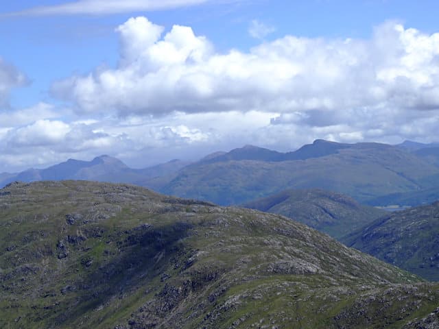
Beinn na h-Uamha — 'the hill of the cave' — is the small but distinctive Corbett of central Sunart, the lowest of the Sunart Corbetts at 762m but with a sharper character than its neighbours. The summit is approached from Polloch on the minor road north-east of Strontian, with a steep walk up through forestry onto a broad ridge. The view from the top reaches across Loch Shiel to the Glenfinnan Munros and west to the small islands. Often paired with Sgùrr Dhomhnuill from the same Polloch base.
Quick facts
- Height
- 762.4m/ 2501ft
- Prominence
- 269 m
- Distance
- 11 km
- Ascent
- 770 m
- Time
- 3–5 hrs
- Grid ref
- NM917664
- Parking
- NM792688
- Nearest city
- Fort William· 20km
- Dogs
- Dogs on lead required near livestockDog-friendly guide ↗
Height and prominence cross-checked against the Database of British and Irish Hills (CC BY).
No GPX track yet
Walked this route? Share your track to help other walkers.
Standard route
forest track 25% · heather hillside 45% · grassy upper slopes 20% · summit area 10%
Park at the small Polloch road end (NM792688). Cross the river and pick up a stalkers' path heading south through Forestry and Land Scotland plantation. The path climbs steadily onto the open hillside and onto the broad north ridge of Beinn na h-Uamha. A measured walk over moor leads to the cairn at the high point. Allow 5–6 hours.
Terrain
Forestry path on the lower approach — well-maintained but can be muddy. Once clear of the trees, the slope opens out into rough heather and short grass, with the odd rocky outcrop where the rib firms up. The summit ridge is broad and grassy. The cave that gives the hill its name is on the south-west flank below the summit.
In winter
Sunart's maritime climate keeps midwinter snow patchy, but Atlantic depressions move in fast and deliver heavy rain and gale-force wind on the exposed top. The Polloch single-track road is weather-vulnerable; check the forecast before driving. The plantation section is sheltered enough to give a warm-up before the climb hits open ground.
This hill is in the Glen Coe SAIS forecast area. Check SAIS forecasts in winter (December–April).
Best time of year
Getting there
- Glasgow3h 35m
- Edinburgh3h 8m
OS maps: OS Landranger 40
Mobile signal: No usable signal at Polloch or on the hill — Loch Doilet sits in a deep Sunart valley shielded from cell coverage. Brief EE on the highest summit ridge
Current conditions
Daylight Today
- Sunrise
- 04:48
- Sunset
- 22:07
- Civil dawn
- 03:48
- Civil dusk
- 23:06
NOAA Solar Calculator · 13 July 2026
Pair with
Curated multi-hill combinations from Beinn na h-Uamha.
Around Beinn na h-Uamha on the SCOT network
Getting there, basing yourself, and what to do off the hill.
Getting there: Glenfinnan station
Glenfinnan Viaduct; Streap, Sgurr Thuilm, Glen Finnan Munros
14km from the hill
tripscot.co.uk
On TripSCOTBase yourself in Fort William
Ben Nevis base, West Highland Line, gateway to Lochaber
20km from the hill
tripscot.co.uk
On TasteSCOTAfter the hill: Ben Nevis Distillery
Fort William — Lochaber distillery at the foot of the Ben; long-aged Japanese-owned classics
23km from the hill
tastescot.co.uk
Beinn na h-Uamha — common questions
- What difficulty is Beinn na h-Uamha?
- On the OutdoorSCOT scale, Beinn na h-Uamha comes in at 2/5 — moderate. Expect roughly 11km and 770m of ascent on the usual route — 3-5 hours for most parties. Underfoot: Forestry path on the lower approach — well-maintained but can be muddy.
- What is Beinn na h-Uamha's prominence?
- 269m of prominence. That's the vertical drop from the summit to the col that links Beinn na h-Uamha to the next higher ground.
- Where do I park for Beinn na h-Uamha?
- Most walkers start from NM792688. Verify the grid reference on an OS map before you set off — space is tight on busy summer weekends.
- When is the best time to climb Beinn na h-Uamha?
- May, June, July, August, September give the most reliable conditions on Beinn na h-Uamha. Beyond that window the high ground turns wintry: carry full mountain kit, be confident navigating, and check the SAIS avalanche forecast for the area.
- Is Beinn na h-Uamha dog-friendly?
- Yes, but dogs must be kept on a lead — there is livestock or ground-nesting bird interest on the route.
- Is there mobile signal on Beinn na h-Uamha?
- No usable signal at Polloch or on the hill — Loch Doilet sits in a deep Sunart valley shielded from cell coverage. Brief EE on the highest summit ridge
- Is Beinn na h-Uamha safe in winter?
- Sunart's maritime climate keeps midwinter snow patchy, but Atlantic depressions move in fast and deliver heavy rain and gale-force wind on the exposed top. The Polloch single-track road is weather-vulnerable; check the forecast before driving. The plantation section is sheltered enough to give a warm-up before the climb hits open ground.
Get the OutdoorSCOT weekly
One email a week — new route, hill and bothy guides, seasonal conditions and the odd hard-won lesson. No spam, unsubscribe in one click.