Corbett · Moidart
Sgurr Dhomhnuill
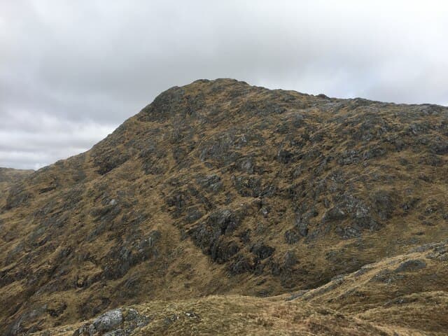
Sgùrr Dhomhnuill is the highest summit in the Sunart hills and one of the most striking peaks of Ardgour — a sharp 888m pyramid visible across Loch Sunart from the road between Strontian and Salen. The mountain has remarkable prominence (over 870m from key col to summit), giving it an outsized presence despite the modest absolute height. Reached by walking deep into the heart of the peninsula from Polloch or Strontian, the summit cone is small and rocky with a stone shelter, and the views west to Mull, Rum and the Atlantic feel hard-earned.
Quick facts
- Height
- 888.4m/ 2915ft
- Prominence
- 873 m
- Distance
- 18 km
- Ascent
- 1050 m
- Time
- 6–9 hrs
- Grid ref
- NM889678
- Parking
- NM837664
- Nearest city
- Fort William· 22km
- Dogs
- Dogs on lead required near livestockDog-friendly guide ↗
Height and prominence cross-checked against the Database of British and Irish Hills (CC BY).
No GPX track yet
Walked this route? Share your track to help other walkers.
Standard route
glen track 30% · heather hillside 35% · rocky ridge 25% · summit rocks 10%
Park at Bellsgrove Loch on the minor road north of Strontian (NM837664), the start of the Polloch road. Walk north-east into Glen Hurich for around 5km on a forestry track. Where the track ends, follow a stalkers' path north-east to the bealach below the south ridge of Sgùrr Dhomhnuill. The route then climbs steeply onto the rocky upper cone — easy scrambling on the final push to the summit. Allow 7–8 hours.
Terrain
Forestry track on the lower approach, then a stalkers' path improves the middle section. The upper hill is rough rock and grass with a clear path to the bealach. The final pull onto the summit cone involves easy hands-on scrambling over exposed mica schist — sound rock when dry, slippery in wet.
In winter
Sgùrr Dhomhnuill in winter is a major mountaineering undertaking — long, remote, and topped by a technical schist cone. The schist upper section ices up readily and the descent in poor visibility is committing. The Strontian-to-Polloch road can close in heavy weather. A hill for experienced winter mountaineers with full kit and a stable forecast.
This hill is in the Glen Coe SAIS forecast area. Check SAIS forecasts in winter (December–April).
Best time of year
Getting there
- Glasgow3h 38m
- Edinburgh3h 11m
OS maps: OS Landranger 40
Mobile signal: No signal on this remote Ardnamurchan/Moidart hill
Current conditions
Daylight Today
- Sunrise
- 04:48
- Sunset
- 22:07
- Civil dawn
- 03:48
- Civil dusk
- 23:07
NOAA Solar Calculator · 13 July 2026
Pair with
Curated multi-hill combinations from Sgurr Dhomhnuill.
Around Sgurr Dhomhnuill on the SCOT network
Getting there, basing yourself, and what to do off the hill.
Getting there: Glenfinnan station
Glenfinnan Viaduct; Streap, Sgurr Thuilm, Glen Finnan Munros
13km from the hill
tripscot.co.uk
On TripSCOTBase yourself in Fort William
Ben Nevis base, West Highland Line, gateway to Lochaber
22km from the hill
tripscot.co.uk
On TasteSCOTAfter the hill: Ben Nevis Distillery
Fort William — Lochaber distillery at the foot of the Ben; long-aged Japanese-owned classics
25km from the hill
tastescot.co.uk
Sgurr Dhomhnuill — common questions
- How difficult is Sgurr Dhomhnuill?
- Sgurr Dhomhnuill carries a 4/5 (challenging) grade on the OutdoorSCOT scale. Count on about 18km, 1050m of ascent and a 6-9 hour day on the standard route. Ground conditions: Forestry track on the lower approach, then a stalkers' path improves the middle section.
- How much drop does Sgurr Dhomhnuill have?
- The drop is 873m: measured from the summit of Sgurr Dhomhnuill down to the saddle joining it to higher terrain.
- Where's the parking for Sgurr Dhomhnuill?
- Park at NM837664. Double-check the grid reference on an OS map first; informal laybys here fill early in high season.
- What's the best month to climb Sgurr Dhomhnuill?
- Aim for May, June, July, August, September on Sgurr Dhomhnuill. In the remaining months treat it as a winter hill — full kit, solid navigation, and a look at the relevant SAIS avalanche forecast before you go.
- Can dogs go up Sgurr Dhomhnuill?
- Dogs are fine on a lead. The route passes livestock or ground-nesting bird habitat, so keep them close throughout.
- Will I get phone signal on Sgurr Dhomhnuill?
- No signal on this remote Ardnamurchan/Moidart hill
- Is Sgurr Dhomhnuill safe in winter?
- Sgùrr Dhomhnuill in winter is a major mountaineering undertaking — long, remote, and topped by a technical schist cone. The schist upper section ices up readily and the descent in poor visibility is committing. The Strontian-to-Polloch road can close in heavy weather. A hill for experienced winter mountaineers with full kit and a stable forecast.
Get the OutdoorSCOT weekly
One email a week — new route, hill and bothy guides, seasonal conditions and the odd hard-won lesson. No spam, unsubscribe in one click.