Graham · Glen Coe & Lochaber
Sgurr a' Chaorainn
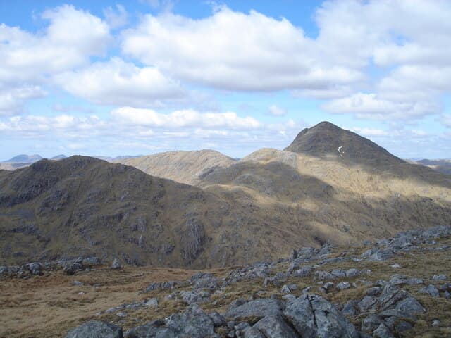
A rocky Ardgour Graham on the watershed between Glen Gour and Glen Scaddle, paired naturally with the Corbett Sgurr Dhomhnuill which rises just to the south-west. The summit has a fine pointed character and gives a quiet alternative to its better-known neighbour on this trackless peninsula.
Quick facts
- Height
- 760.6m/ 2495ft
- Prominence
- 205 m
- Distance
- 14 km
- Ascent
- 623 m
- Time
- 4–7 hrs
- Grid ref
- NM894662
- Parking
- NM963635
- Nearest city
- Fort William· 22km
- Dogs
- Dogs on lead required near livestockDog-friendly guide ↗
Height and prominence cross-checked against the Database of British and Irish Hills (CC BY).
No GPX track yet
Walked this route? Share your track to help other walkers.
Standard route
glen track 25% · heather hillside 45% · grassy upper ridge 20% · summit area 10%
Approach from Sallachan on Loch Linnhe via the long track up Glen Gour, then cut south up steep grass to gain the bealach below the summit. Final pull is on broken rock and turf to a small rocky top.
Terrain
Decent argocat track up Glen Gour, then pathless steep grass and short heather above. The summit cone has scattered slabby outcrops but no scrambling required on the standard line.
In winter
Ardgour catches the full force of Atlantic weather and the upper slopes can ice up after a clearance. Hidden burns and drifted snow in the corries on the north side are the main winter concerns.
This hill is in the Glen Coe SAIS forecast area. Check SAIS forecasts in winter (December–April).
Best time of year
Getting there
- Glasgow3h 36m
- Edinburgh3h 9m
OS maps: OS Landranger 40
Mobile signal: No signal in this Glen Elchaig/Kintail area
Current conditions
Daylight Today
- Sunrise
- 04:48
- Sunset
- 22:07
- Civil dawn
- 03:48
- Civil dusk
- 23:07
NOAA Solar Calculator · 13 July 2026
Around Sgurr a' Chaorainn on the SCOT network
Getting there, basing yourself, and what to do off the hill.
Getting there: Glenfinnan station
Glenfinnan Viaduct; Streap, Sgurr Thuilm, Glen Finnan Munros
14km from the hill
tripscot.co.uk
On TripSCOTBase yourself in Fort William
Ben Nevis base, West Highland Line, gateway to Lochaber
22km from the hill
tripscot.co.uk
On TasteSCOTAfter the hill: Ben Nevis Distillery
Fort William — Lochaber distillery at the foot of the Ben; long-aged Japanese-owned classics
25km from the hill
tastescot.co.uk
Sgurr a' Chaorainn — common questions
- Is Sgurr a' Chaorainn a hard climb?
- Sgurr a' Chaorainn is rated 2/5 (moderate) on the OutdoorSCOT scale. The standard route covers about 14km with 623m of ascent and takes most walkers 4-7 hours. Terrain: Decent argocat track up Glen Gour, then pathless steep grass and short heather above.
- How prominent is Sgurr a' Chaorainn?
- Sgurr a' Chaorainn has 205m of topographic prominence — the height of its summit above the highest col connecting it to higher ground.
- Where should I park to climb Sgurr a' Chaorainn?
- Standard parking is at NM963635. Check the parking grid reference on an OS map before travel; informal laybys can fill on summer weekends.
- When should I climb Sgurr a' Chaorainn?
- The standard good-weather months for Sgurr a' Chaorainn are May, June, July, August, September. Outside those months, expect winter conditions on the high ground — full mountain kit, navigation skills, and a check of the SAIS avalanche forecast for the relevant region.
- Can I bring my dog up Sgurr a' Chaorainn?
- On a lead only — the route crosses ground with livestock or nesting-bird interest.
- What's mobile reception like on Sgurr a' Chaorainn?
- No signal in this Glen Elchaig/Kintail area
- Is Sgurr a' Chaorainn safe in winter?
- Ardgour catches the full force of Atlantic weather and the upper slopes can ice up after a clearance. Hidden burns and drifted snow in the corries on the north side are the main winter concerns.
Get the OutdoorSCOT weekly
One email a week — new route, hill and bothy guides, seasonal conditions and the odd hard-won lesson. No spam, unsubscribe in one click.