Graham · Glen Coe & Lochaber
Beinn Bheag
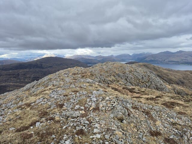
A modest Graham above the north shore of Loch Sunart, tucked between Strontian and Glen Tarbert. Despite the unassuming name it gives a sweeping panorama south over Sunart and across to the Morvern hills.
Gaelic: “mountain, small” · Pronunciation: bine vek
Quick facts
- Height
- 737.4m/ 2419ft
- Prominence
- 202 m
- Distance
- 14 km
- Ascent
- 604 m
- Time
- 4–7 hrs
- Grid ref
- NM914635
- Nearest city
- Fort William· 22km
- Dogs
- Dogs on lead required near livestockDog-friendly guide ↗
Height and prominence cross-checked against the Database of British and Irish Hills (CC BY).
No GPX track yet
Walked this route? Share your track to help other walkers.
Standard route
moorland path 25% · heather moorland 45% · grassy upper slopes 20% · summit area 10%
Park near the old Ariundle oakwoods reserve at the head of the Strontian River. Follow the marked trails north-west into Glen Hurich, then leave the path and climb the south spur of the hill through open birch and rowan onto the heather summit.
Terrain
Oak and birch woodland on the lower slopes, then heather and rocky outcrops. The summit area carries small lochans and slabby granite — pleasant walking once above the trees.
In winter
Sunart's microclimate keeps the lower slopes largely snow-free. Higher up the slabs ice over quickly after rain and become slippery. The Ariundle paths can flood after heavy rain.
This hill is in the Glen Coe SAIS forecast area. Check SAIS forecasts in winter (December–April).
Best time of year
Getting there
- Glasgow3h 32m
- Edinburgh3h 6m
OS maps: OS Landranger 40, OS Explorer 391
Mobile signal: Reception at Strontian village; nothing higher up Glen Hurich
Current conditions
Daylight Today
- Sunrise
- 04:48
- Sunset
- 22:06
- Civil dawn
- 03:49
- Civil dusk
- 23:06
NOAA Solar Calculator · 13 July 2026
Around Beinn Bheag on the SCOT network
Getting there, basing yourself, and what to do off the hill.
Getting there: Glenfinnan station
Glenfinnan Viaduct; Streap, Sgurr Thuilm, Glen Finnan Munros
17km from the hill
tripscot.co.uk
On TripSCOTBase yourself in Fort William
Ben Nevis base, West Highland Line, gateway to Lochaber
22km from the hill
tripscot.co.uk
On TasteSCOTAfter the hill: Ben Nevis Distillery
Fort William — Lochaber distillery at the foot of the Ben; long-aged Japanese-owned classics
24km from the hill
tastescot.co.uk
Beinn Bheag — common questions
- What difficulty is Beinn Bheag?
- On the OutdoorSCOT scale, Beinn Bheag comes in at 4/5 — challenging. Expect roughly 14km and 604m of ascent on the usual route — 4-7 hours for most parties. Terrain: Oak and birch woodland on the lower slopes, then heather and rocky outcrops.
- How prominent is Beinn Bheag?
- Beinn Bheag has 202m of topographic prominence — the height of its summit above the highest col connecting it to higher ground.
- When should I climb Beinn Bheag?
- The standard good-weather months for Beinn Bheag are May, June, July, August, September. Outside those months, expect winter conditions on the high ground — full mountain kit, navigation skills, and a check of the SAIS avalanche forecast for the relevant region.
- Can I bring my dog up Beinn Bheag?
- On a lead only — the route crosses ground with livestock or nesting-bird interest.
- What's mobile reception like on Beinn Bheag?
- Reception at Strontian village; nothing higher up Glen Hurich
- Is Beinn Bheag safe in winter?
- Sunart's microclimate keeps the lower slopes largely snow-free. Higher up the slabs ice over quickly after rain and become slippery. The Ariundle paths can flood after heavy rain.
Get the OutdoorSCOT weekly
One email a week — new route, hill and bothy guides, seasonal conditions and the odd hard-won lesson. No spam, unsubscribe in one click.