Corbett · Ardnamurchan
Garbh Bheinn
Garbh Bheinn of Ardgour is widely regarded as the finest non-Munro mountain in Scotland — an 885m rocky peak rising above the south side of Loch Linnhe with three classic ridges, a famous Great Ridge with established rock climbs since the 1890s, and a reputation that has drawn generations of scramblers and climbers across the Corran Ferry. The summit gives a panorama across to Ben Nevis and the Mamores. The hill is approached from the small parking area on the road over to Strontian, and the routes range from a steady walking ascent to serious mountaineering.
Gaelic: “rough” · Pronunciation: garrav bheinn
Quick facts
- Height
- 885.6m/ 2906ft
- Prominence
- 688 m
- Distance
- ~13 km
- Ascent
- ~950 m
- Time
- 4–7 hrs
- Grid ref
- NM904622
- Parking
- NM928597
- Nearest city
- Fort William· 23km
- Dogs
- Dogs on lead required near livestockDog-friendly guide ↗
Height and prominence cross-checked against the Database of British and Irish Hills (CC BY).
No GPX track yet
Walked this route? Share your track to help other walkers.
Standard route
glen path 20% · steep grass 25% · rocky scramble 40% · summit rocks 15%
The walking route starts from the layby on the A861 below Coire an Iubhair. Cross the road and follow a path north into the corrie for around 3km. From the corrie floor, climb steeply west onto Sron a' Gharbh Choire Bhig and follow the north-east ridge to the summit. Scramblers prefer the Great Ridge (Grade 3) climbed directly out of the corrie. Descent is best via the north-east ridge in reverse. Allow 6–7 hours for the walking route.
Terrain
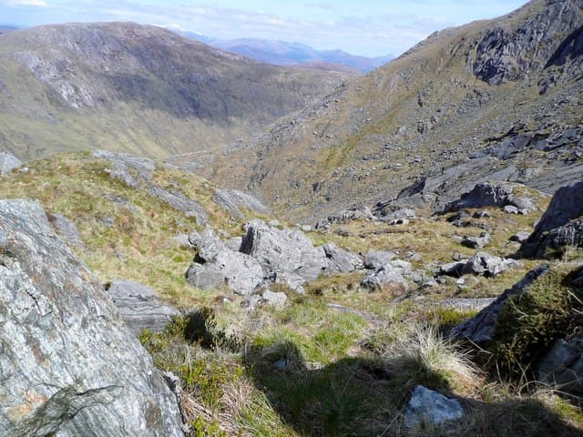
The corrie path is reasonable but boggy in places. The upper mountain is built of metamorphic schist — sharp ridges, rock outcrops, and steep slabs in the corrie below the Great Ridge. The summit crest is sharp-edged with serious drops east and west alike; in cloud, route-finding needs real care.
In winter
Garbh Bheinn counts among the great Scottish winter mountaineering peaks. The Great Ridge in winter is a Grade III/IV climb of legendary status; the walker's route up the north-east ridge becomes a Grade I winter mountaineering route requiring axe, crampons and good judgement. Lee cornices overhang the eastern flank of the summit ridge — give the edge a wide berth.
Kit for this: the winter Munro kit list · which boots take crampons
Best time of year
Getting there
- Glasgow3h 31m
- Edinburgh3h 6m
OS maps: OS Landranger 40, OS Explorer 391
Mobile signal: Patchy on the Ardgour road; no signal in Coire an Iubhair or on the summit; better at the Corran Ferry slipway
Current conditions
Daylight Today
- Sunrise
- 07:51
- Sunset
- 18:24
- Civil dawn
- 07:13
- Civil dusk
- 19:02
NOAA Solar Calculator · 14 October 2026
Pair with
Curated multi-hill combinations from Garbh Bheinn.
Around Garbh Bheinn on the SCOT network
Getting there, basing yourself, and what to do off the hill.
Getting there: Glenfinnan station
Glenfinnan Viaduct; Streap, Sgurr Thuilm, Glen Finnan Munros
18km from the hill
tripscot.co.uk
On TripSCOTBase yourself in Glencoe
Three Sisters, Aonach Eagach and the Lost Valley — village base on Loch Leven
20km from the hill
tripscot.co.uk
On TasteSCOTAfter the hill: Ben Nevis Distillery
Fort William — Lochaber distillery at the foot of the Ben; long-aged Japanese-owned classics
26km from the hill
tastescot.co.uk
Garbh Bheinn — common questions
- How hard is Garbh Bheinn?
- We grade Garbh Bheinn at 3/5, which puts it in moderately challenging territory. The usual route is around 13km with 950m of climbing; allow 4-7 hours. Ground conditions: The corrie path is reasonable but boggy in places.
- How much drop does Garbh Bheinn have?
- The drop is 688m: measured from the summit of Garbh Bheinn down to the saddle joining it to higher terrain.
- Where's the parking for Garbh Bheinn?
- Park at NM928597. Double-check the grid reference on an OS map first; informal laybys here fill early in high season.
- What's the best month to climb Garbh Bheinn?
- Aim for May, June, July, August, September on Garbh Bheinn. In the remaining months treat it as a winter hill — full kit, solid navigation, and a look at the relevant SAIS avalanche forecast before you go.
- Can dogs go up Garbh Bheinn?
- Dogs are fine on a lead. The route passes livestock or ground-nesting bird habitat, so keep them close throughout.
- Will I get phone signal on Garbh Bheinn?
- Patchy on the Ardgour road; no signal in Coire an Iubhair or on the summit; better at the Corran Ferry slipway
- Is Garbh Bheinn safe in winter?
- Garbh Bheinn counts among the great Scottish winter mountaineering peaks. The Great Ridge in winter is a Grade III/IV climb of legendary status; the walker's route up the north-east ridge becomes a Grade I winter mountaineering route requiring axe, crampons and good judgement. Lee cornices overhang the eastern flank of the summit ridge — give the edge a wide berth.
Get the OutdoorSCOT weekly
One email a week — new route, hill and bothy guides, seasonal conditions and the odd hard-won lesson. No spam, unsubscribe in one click.