Corbett · Ardgour
Fuar Bheinn
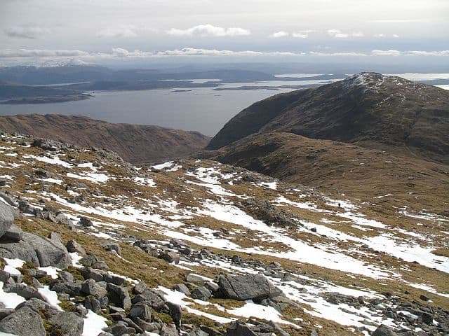
Fuar Bheinn — 'the cold hill' — is the 766m Corbett in the wild country of Kingairloch in southern Morvern, the rugged peninsula south of Loch Sunart. Together with neighbouring Creach Bheinn (also a Corbett) it forms a natural double from the road end at Kingairloch. The summit looks out across Loch Linnhe to the Glen Coe peaks and south to the small islands and the Argyll coast. A remote feel for what is, on the map, only a moderate distance from the road.
Quick facts
- Height
- 766m/ 2513ft
- Prominence
- 226 m
- Distance
- 11 km
- Ascent
- 800 m
- Time
- 3–6 hrs
- Grid ref
- NM853563
- Parking
- NM862544
- Nearest city
- Oban· 26km
- Dogs
- Dogs on lead required near livestockDog-friendly guide ↗
Height and prominence cross-checked against the Database of British and Irish Hills (CC BY).
No GPX track yet
Walked this route? Share your track to help other walkers.
Standard route
ferry approach 10% · heather hillside 50% · grassy upper ridge 30% · summit area 10%
Park at Kingairloch House on the minor road south from Loch Sunart (NM862544). Walk north up the estate track for around 2km, then leave the track and climb north-west onto Fuar Bheinn's wide southern flank. A sustained pull through heather and grass tops out at the cairn. For the classic pair, continue north along the ridge to Creach Bheinn, then descend west into Glen Galmadale and rejoin the track. Allow 5–6 hours for Fuar Bheinn alone, 8–9 for the pair.
Terrain
Estate track on the approach. The hillside is heather and grass with rock outcrops on the upper section — sound underfoot in the dry, slippery when wet. The summit area mixes solid rock and turf, marked by a small cairn. The connecting ridge to Creach Bheinn is broad and easy in good weather.
In winter
Maritime Morvern winter — snow rarely persistent and Atlantic systems push through with heavy rain and savage wind across the exposed ridge. The Kingairloch road is single-track and can drift. The summit's east-facing aspect catches the prevailing wind. In firm conditions a satisfying short winter day with stunning Glen Coe views.
This hill is in the Glen Coe SAIS forecast area. Check SAIS forecasts in winter (December–April).
Best time of year
Getting there
- Glasgow2h 29m
- Edinburgh3h 7m
OS maps: OS Landranger 49
Mobile signal: No signal in Ardgour/Corran area
Current conditions
Daylight Today
- Sunrise
- 04:49
- Sunset
- 22:06
- Civil dawn
- 03:50
- Civil dusk
- 23:06
NOAA Solar Calculator · 13 July 2026
Pair with
Curated multi-hill combinations from Fuar Bheinn.
Around Fuar Bheinn on the SCOT network
Getting there, basing yourself, and what to do off the hill.
Getting there: Glenfinnan station
Glenfinnan Viaduct; Streap, Sgurr Thuilm, Glen Finnan Munros
25km from the hill
tripscot.co.uk
On TripSCOTBase yourself in Oban
Argyll ferry hub — Mull, Lismore, Coll, Tiree, Barra
26km from the hill
tripscot.co.uk
On TasteSCOTAfter the hill: Oban
Oban town centre — tiny two-still distillery bridging Highland and West Coast styles
26km from the hill
tastescot.co.uk
Fuar Bheinn — common questions
- How hard is Fuar Bheinn?
- We grade Fuar Bheinn at 3/5, which puts it in moderately challenging territory. The usual route is around 11km with 800m of climbing; allow 3-6 hours. Terrain: Estate track on the approach.
- How prominent is Fuar Bheinn?
- Fuar Bheinn has 226m of topographic prominence — the height of its summit above the highest col connecting it to higher ground.
- Where should I park to climb Fuar Bheinn?
- Standard parking is at NM862544. Check the parking grid reference on an OS map before travel; informal laybys can fill on summer weekends.
- When should I climb Fuar Bheinn?
- The standard good-weather months for Fuar Bheinn are April, May, June, July, August, September, October. Outside those months, expect winter conditions on the high ground — full mountain kit, navigation skills, and a check of the SAIS avalanche forecast for the relevant region.
- Can I bring my dog up Fuar Bheinn?
- On a lead only — the route crosses ground with livestock or nesting-bird interest.
- What's mobile reception like on Fuar Bheinn?
- No signal in Ardgour/Corran area
- Is Fuar Bheinn safe in winter?
- Maritime Morvern winter — snow rarely persistent and Atlantic systems push through with heavy rain and savage wind across the exposed ridge. The Kingairloch road is single-track and can drift. The summit's east-facing aspect catches the prevailing wind. In firm conditions a satisfying short winter day with stunning Glen Coe views.
Get the OutdoorSCOT weekly
One email a week — new route, hill and bothy guides, seasonal conditions and the odd hard-won lesson. No spam, unsubscribe in one click.