Graham · Glen Coe & Lochaber
Beinn Mheadhoin
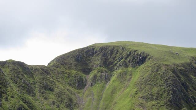
A quiet Graham at the heart of the Morvern peninsula, looking out across Loch Sunart to Ardnamurchan and inland to Loch Arienas. The summit is rarely visited and the moorland around it carries one of the largest red deer populations in Argyll.
Quick facts
- Height
- 739m/ 2425ft
- Prominence
- 568 m
- Distance
- 14 km
- Ascent
- 606 m
- Time
- 4–7 hrs
- Grid ref
- NM799514
- Nearest city
- Oban· 22km
- Dogs
- Dogs on lead required near livestockDog-friendly guide ↗
Height and prominence cross-checked against the Database of British and Irish Hills (CC BY).
No GPX track yet
Walked this route? Share your track to help other walkers.
Standard route
glen access 15% · heather hillside 50% · grassy upper slopes 25% · summit area 10%
Approach from the minor road along the north shore of Loch Arienas. Cross the Allt Mungasdail and climb the south-west spur onto rolling moorland. The top is a broad grassy dome with a small cairn — a wander rather than a route.
Terrain
Boggy heather and tussock for the lower two-thirds. Higher up the ground firms to short grass and granite blocks. No path of any kind — entirely on faint deer tracks.
In winter
Snow rarely lies long in Morvern thanks to the Atlantic influence. The real winter issues here are short daylight, ferry timetables and the deer stalking season — check with Ardtornish Estate before going.
This hill is in the Glen Coe SAIS forecast area. Check SAIS forecasts in winter (December–April).
Best time of year
Getting there
- Glasgow2h 29m
- Edinburgh3h 10m
OS maps: OS Landranger 49, OS Explorer 383
Mobile signal: No signal in central Morvern; nearest reliable bars at Lochaline pier
Current conditions
Daylight Today
- Sunrise
- 04:56
- Sunset
- 22:01
- Civil dawn
- 03:59
- Civil dusk
- 22:58
NOAA Solar Calculator · 17 July 2026
Around Beinn Mheadhoin on the SCOT network
Getting there, basing yourself, and what to do off the hill.
Getting there: Oban station
Argyll ferry hub; Mull, Lismore, Coll, Tiree, Barra connections
22km from the hill
tripscot.co.uk
On TripSCOTBase yourself in Oban
Argyll ferry hub — Mull, Lismore, Coll, Tiree, Barra
22km from the hill
tripscot.co.uk
On TasteSCOTAfter the hill: Oban
Oban town centre — tiny two-still distillery bridging Highland and West Coast styles
22km from the hill
tastescot.co.uk
Beinn Mheadhoin — common questions
- What difficulty is Beinn Mheadhoin?
- On the OutdoorSCOT scale, Beinn Mheadhoin comes in at 4/5 — challenging. Expect roughly 14km and 606m of ascent on the usual route — 4-7 hours for most parties. Ground conditions: Boggy heather and tussock for the lower two-thirds.
- How much drop does Beinn Mheadhoin have?
- The drop is 568m: measured from the summit of Beinn Mheadhoin down to the saddle joining it to higher terrain.
- What's the best month to climb Beinn Mheadhoin?
- Aim for May, June, July, August, September on Beinn Mheadhoin. In the remaining months treat it as a winter hill — full kit, solid navigation, and a look at the relevant SAIS avalanche forecast before you go.
- Can dogs go up Beinn Mheadhoin?
- Dogs are fine on a lead. The route passes livestock or ground-nesting bird habitat, so keep them close throughout.
- Will I get phone signal on Beinn Mheadhoin?
- No signal in central Morvern; nearest reliable bars at Lochaline pier
- Is Beinn Mheadhoin safe in winter?
- Snow rarely lies long in Morvern thanks to the Atlantic influence. The real winter issues here are short daylight, ferry timetables and the deer stalking season — check with Ardtornish Estate before going.
Get the OutdoorSCOT weekly
One email a week — new route, hill and bothy guides, seasonal conditions and the odd hard-won lesson. No spam, unsubscribe in one click.