Graham · Glen Coe & Lochaber
Beinn na Cille
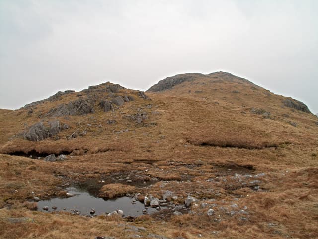
Beinn na Cille (652m) — the hill of the church — rises steeply out of Glen Tarbert in the NM85 square, dividing Loch Sunart from Loch Linnhe. The rocky top gives a wide sweep east to Ben Nevis and south down Loch Linnhe to the Corran Narrows.
Quick facts
- Height
- 652m/ 2139ft
- Prominence
- 193 m
- Distance
- 13 km
- Ascent
- 535 m
- Time
- 3–6 hrs
- Grid ref
- NM853542
- Parking
- NM935598
- Nearest city
- Oban· 24km
- Dogs
- Dogs on lead required near livestockDog-friendly guide ↗
Height and prominence cross-checked against the Database of British and Irish Hills (CC BY).
No GPX track yet
Walked this route? Share your track to help other walkers.
Standard route
heather moorland 65% · grass slopes 25% · rocky summit 10%
Park near the road junction at Inversanda on the A861. Cross the bridge and follow the deer fence north-west onto open hillside, climbing the steep south-east spur direct. The angle relents on the broad upper crest where short heather and rock lead pleasantly to the summit boulder.
Terrain
Deer fence and steep grassy gully at the start, then quartzite outcrops and short heather on the spur. The summit area is firm and open with the rock marker easily seen on approach.
In winter
Glen Tarbert catches Atlantic snow that turns to verglas on the quartzite outcrops overnight. The steep south-east spur becomes a serious axe-and-crampon proposition in winter conditions, and a SAIS West Highlands check is recommended for any rimed-rock day.
This hill is in the Glen Coe SAIS forecast area. Check SAIS forecasts in winter (December–April).
Best time of year
Getting there
- Glasgow2h 27m
- Edinburgh3h 6m
OS maps: OS Landranger 49
Mobile signal: Poor. Remote Glen Tarbert / Inversanda area; weak on most networks.
Current conditions
Daylight Today
- Sunrise
- 04:55
- Sunset
- 22:01
- Civil dawn
- 03:58
- Civil dusk
- 22:58
NOAA Solar Calculator · 17 July 2026
Around Beinn na Cille on the SCOT network
Getting there, basing yourself, and what to do off the hill.
Getting there: Oban station
Argyll ferry hub; Mull, Lismore, Coll, Tiree, Barra connections
24km from the hill
tripscot.co.uk
On TripSCOTBase yourself in Oban
Argyll ferry hub — Mull, Lismore, Coll, Tiree, Barra
24km from the hill
tripscot.co.uk
On TasteSCOTAfter the hill: Oban
Oban town centre — tiny two-still distillery bridging Highland and West Coast styles
24km from the hill
tastescot.co.uk
Beinn na Cille — common questions
- How difficult is Beinn na Cille?
- Beinn na Cille carries a 3/5 (moderately challenging) grade on the OutdoorSCOT scale. Count on about 13km, 535m of ascent and a 3-6 hour day on the standard route. Underfoot: Deer fence and steep grassy gully at the start, then quartzite outcrops and short heather on the spur.
- What is Beinn na Cille's prominence?
- 193m of prominence. That's the vertical drop from the summit to the col that links Beinn na Cille to the next higher ground.
- Where do I park for Beinn na Cille?
- Most walkers start from NM935598. Verify the grid reference on an OS map before you set off — space is tight on busy summer weekends.
- When is the best time to climb Beinn na Cille?
- May, June, July, August, September give the most reliable conditions on Beinn na Cille. Beyond that window the high ground turns wintry: carry full mountain kit, be confident navigating, and check the SAIS avalanche forecast for the area.
- Is Beinn na Cille dog-friendly?
- Yes, but dogs must be kept on a lead — there is livestock or ground-nesting bird interest on the route.
- Is there mobile signal on Beinn na Cille?
- Poor. Remote Glen Tarbert / Inversanda area; weak on most networks.
- Is Beinn na Cille safe in winter?
- Glen Tarbert catches Atlantic snow that turns to verglas on the quartzite outcrops overnight. The steep south-east spur becomes a serious axe-and-crampon proposition in winter conditions, and a SAIS West Highlands check is recommended for any rimed-rock day.
Get the OutdoorSCOT weekly
One email a week — new route, hill and bothy guides, seasonal conditions and the odd hard-won lesson. No spam, unsubscribe in one click.