Corbett · Ardgour
Creach Bheinn
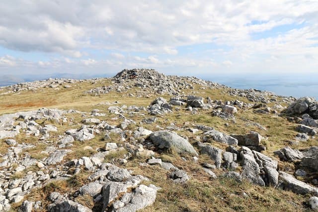
This Creach Bheinn — "the hill of plunder", a common name in Scotland — is the high point of the Morvern peninsula, the long quiet finger of land between Loch Linnhe and the Sound of Mull. At 853m a small cairn crowns a rocky top with an outstanding seaward outlook: Mull and Lismore to the west, Ardgour and Garbh Bheinn across Loch Linnhe to the east, and the Small Isles on the horizon. Morvern is rarely busy and Creach Bheinn even quieter — many baggers never reach it.
Quick facts
- Height
- 853m/ 2799ft
- Prominence
- 755 m
- Distance
- 15 km
- Ascent
- 751 m
- Time
- 5–7 hrs
- Grid ref
- NM870576
- Parking
- NM872474
- Nearest city
- Oban· 27km
- Dogs
- Dogs on lead required near livestockDog-friendly guide ↗
Height and prominence cross-checked against the Database of British and Irish Hills (CC BY).
No GPX track yet
Walked this route? Share your track to help other walkers.
Standard route
glen track 30% · rough moor 35% · broken ridge 25% · summit cairn 10%
The most direct approach is from the A884 near Acharn or Claggan, taking the Glen Galmadale estate track north to the head of the glen and then climbing west onto the long south ridge of Creach Bheinn. Alternative starts from Glensanda or Kingairloch are longer. Around 15km return with 751m of ascent for the standard line. The summit ridge runs north-west over a series of small tops; navigation matters in mist.
Terrain
The Glen Galmadale track is firm for the lower half then degrades to wet peat where it ends. The open hillside above is rough heather and grass with scattered crags — pathless and slow but not technical. The summit ridge is broken rock and short turf with the cairn on the highest top of several similar bumps. The west flank above Loch Linnhe falls away in crag bands; keep east of the obvious edge.
In winter
A maritime Morvern Corbett where snow cover is intermittent and rarely deep — but the long approach across exposed moor catches the full Atlantic weather pattern. The ridge ices up readily and the west-facing crags hold verglas into late spring. The single-track A884 is reliable but rural; expect slow driving in any weather.
This hill is in the Glen Coe SAIS forecast area. Check SAIS forecasts in winter (December–April).
Best time of year
Getting there
- Glasgow2h 29m
- Edinburgh3h 6m
OS maps: OS Landranger 49, OS Explorer 383
Mobile signal: No signal in interior Morvern; Lochaline village has reasonable coverage
Current conditions
Daylight Today
- Sunrise
- 04:55
- Sunset
- 22:01
- Civil dawn
- 03:58
- Civil dusk
- 22:58
NOAA Solar Calculator · 17 July 2026
Pair with
Curated multi-hill combinations from Creach Bheinn.
Around Creach Bheinn on the SCOT network
Getting there, basing yourself, and what to do off the hill.
Getting there: Glenfinnan station
Glenfinnan Viaduct; Streap, Sgurr Thuilm, Glen Finnan Munros
23km from the hill
tripscot.co.uk
On TripSCOTBase yourself in Oban
Argyll ferry hub — Mull, Lismore, Coll, Tiree, Barra
28km from the hill
tripscot.co.uk
On TasteSCOTAfter the hill: Oban
Oban town centre — tiny two-still distillery bridging Highland and West Coast styles
28km from the hill
tastescot.co.uk
Creach Bheinn — common questions
- Is Creach Bheinn a hard climb?
- Creach Bheinn is rated 3/5 (moderately challenging) on the OutdoorSCOT scale. The standard route covers about 15km with 751m of ascent and takes most walkers 5-7 hours. Underfoot: The Glen Galmadale track is firm for the lower half then degrades to wet peat where it ends.
- What is Creach Bheinn's prominence?
- 755m of prominence. That's the vertical drop from the summit to the col that links Creach Bheinn to the next higher ground.
- Where do I park for Creach Bheinn?
- Most walkers start from NM872474. Verify the grid reference on an OS map before you set off — space is tight on busy summer weekends.
- When is the best time to climb Creach Bheinn?
- May, June, July, August, September give the most reliable conditions on Creach Bheinn. Beyond that window the high ground turns wintry: carry full mountain kit, be confident navigating, and check the SAIS avalanche forecast for the area.
- Is Creach Bheinn dog-friendly?
- Yes, but dogs must be kept on a lead — there is livestock or ground-nesting bird interest on the route.
- Is there mobile signal on Creach Bheinn?
- No signal in interior Morvern; Lochaline village has reasonable coverage
- Is Creach Bheinn safe in winter?
- A maritime Morvern Corbett where snow cover is intermittent and rarely deep — but the long approach across exposed moor catches the full Atlantic weather pattern. The ridge ices up readily and the west-facing crags hold verglas into late spring. The single-track A884 is reliable but rural; expect slow driving in any weather.
Get the OutdoorSCOT weekly
One email a week — new route, hill and bothy guides, seasonal conditions and the odd hard-won lesson. No spam, unsubscribe in one click.