Graham · Glen Coe & Lochaber
Glas Bheinn
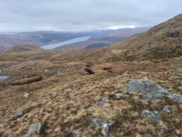
Glas Bheinn (635m) sits at the eastern end of the Morvern peninsula in the NM93 square, looking out over Loch Linnhe toward Lismore and the Appin shore. The grassy summit gives a panorama from Mull through to the Glen Coe tops, with the corrugated ridges of Garbh Bheinn dominating the north. Access from Kingairloch makes this the most logical Morvern Graham for a half-day on the way to Ardnamurchan.
Gaelic: “grey-green” · Pronunciation: glass bheinn
Quick facts
- Height
- 635.3m/ 2084ft
- Prominence
- 151 m
- Distance
- 12 km
- Ascent
- 476 m
- Time
- 3–5 hrs
- Grid ref
- NM939757
- Parking
- NM930749
- Nearest city
- Fort William· 17km
- Dogs
- Dogs on lead required near livestockDog-friendly guide ↗
Height and prominence cross-checked against the Database of British and Irish Hills (CC BY).
No GPX track yet
Walked this route? Share your track to help other walkers.
Standard route
heather and bog 60% · grass slopes 30% · rocky summit 10%
A track from the parking spot at NM930749 heads up Glencripesdale-side burns onto open hillside. The lower flanks are tussocky with bog crossings either side of the 250m contour; above that, deer trods lead onto sound grass that runs all the way to the top. The summit rock is set on a small grassy plateau and the descent back to Kingairloch on the ascent line is straightforward in clear weather.
Terrain
Tussock grass and bog mosses dominate the approach, with deer fence crossings near 200m. The summit dome is firm grass with a few schist ribs, drying quickly after rain because the wind funnels along the loch. Streams running into Loch a' Choire can be lively after wet spells.
In winter
Glas Bheinn rarely holds deep snow but its loch-side position means heavy sleet and verglas on the schist whenever an Atlantic system pushes through. The summit is exposed to south-west winds funnelling up Loch Linnhe and wind chill can be sharp. SAIS coverage does not extend here, so judge conditions from the freezing level and recent precipitation.
This hill is in the Glen Coe SAIS forecast area. Check SAIS forecasts in winter (December–April).
Best time of year
Getting there
- Glasgow3h 43m
- Edinburgh3h 12m
OS maps: OS Landranger 40
Mobile signal: Poor. Remote Morvern/Ardnamurchan; very limited coverage.
Current conditions
Daylight Today
- Sunrise
- 04:54
- Sunset
- 22:02
- Civil dawn
- 03:55
- Civil dusk
- 23:00
NOAA Solar Calculator · 17 July 2026
Around Glas Bheinn on the SCOT network
Getting there, basing yourself, and what to do off the hill.
Getting there: Glenfinnan station
Glenfinnan Viaduct; Streap, Sgurr Thuilm, Glen Finnan Munros
6km from the hill
tripscot.co.uk
On TripSCOTBase yourself in Fort William
Ben Nevis base, West Highland Line, gateway to Lochaber
17km from the hill
tripscot.co.uk
On TasteSCOTAfter the hill: Ben Nevis Distillery
Fort William — Lochaber distillery at the foot of the Ben; long-aged Japanese-owned classics
18km from the hill
tastescot.co.uk
Glas Bheinn — common questions
- What difficulty is Glas Bheinn?
- On the OutdoorSCOT scale, Glas Bheinn comes in at 3/5 — moderately challenging. Expect roughly 12km and 476m of ascent on the usual route — 3-5 hours for most parties. Underfoot: Tussock grass and bog mosses dominate the approach, with deer fence crossings near 200m.
- What is Glas Bheinn's prominence?
- 151m of prominence. That's the vertical drop from the summit to the col that links Glas Bheinn to the next higher ground.
- Where do I park for Glas Bheinn?
- Most walkers start from NM930749. Verify the grid reference on an OS map before you set off — space is tight on busy summer weekends.
- When is the best time to climb Glas Bheinn?
- May, June, July, August, September give the most reliable conditions on Glas Bheinn. Beyond that window the high ground turns wintry: carry full mountain kit, be confident navigating, and check the SAIS avalanche forecast for the area.
- Is Glas Bheinn dog-friendly?
- Yes, but dogs must be kept on a lead — there is livestock or ground-nesting bird interest on the route.
- Is there mobile signal on Glas Bheinn?
- Poor. Remote Morvern/Ardnamurchan; very limited coverage.
- Is Glas Bheinn safe in winter?
- Glas Bheinn rarely holds deep snow but its loch-side position means heavy sleet and verglas on the schist whenever an Atlantic system pushes through. The summit is exposed to south-west winds funnelling up Loch Linnhe and wind chill can be sharp. SAIS coverage does not extend here, so judge conditions from the freezing level and recent precipitation.
Get the OutdoorSCOT weekly
One email a week — new route, hill and bothy guides, seasonal conditions and the odd hard-won lesson. No spam, unsubscribe in one click.