Munro · Glen Coe & Lochaber
Sgurr Thuilm
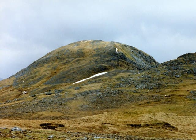
Sgùrr Thuilm (963m) — "peak of the rounded hillock" — is the eastern Munro of the Glenfinnan pair, paired with Sgùrr nan Coireachan to the west across a long undulating connecting ridge. The hill rises directly above the celebrated Glenfinnan Viaduct (of Harry Potter / West Highland Line fame) and the head of Loch Shiel. Together the two Munros form a fine horseshoe round from Corryhully bothy.
Quick facts
- Height
- 963m/ 3159ft
- Prominence
- 614 m
- Distance
- ~17 km
- Ascent
- ~847 m
- Time
- 5–8 hrs
- Grid ref
- NM939879
- Parking
- NM907808
- Nearest city
- Fort William· 22km
- Dogs
- Dogs on lead required near livestockDog-friendly guide ↗
Height and prominence cross-checked against the Database of British and Irish Hills (CC BY).
No GPX track yet
Walked this route? Share your track to help other walkers.
Standard route
Glen path / bothy track 30% · Open hillside 40% · Summit ridge 30%
Park at the National Trust car park at Glenfinnan (charge applies). Walk north up the Gleann Finnan estate track past the famous Glenfinnan viaduct to Corryhully bothy. From the bothy climb the steep south-east ridge of Sgùrr Thuilm directly to the summit. Most parties continue west along the long undulating connecting ridge to Sgùrr nan Coireachan, then descend back to Corryhully. The full pair runs roughly 18km with 1450m of climb.
Terrain
The Glenfinnan estate track to Corryhully is firm landrover surface. The south-east ridge of Sgùrr Thuilm is sustained steep grass and broken rock — a long pull. The summit cairn sits on a small rocky outcrop. The connecting ridge west to Sgùrr nan Coireachan is broad mossy turf with several false summits — slow going under foot. Corryhully bothy is a basic but useful overnight shelter.
In winter
A serious west-coast winter day with significant commitment. The south-east ridge accumulates wind-driven snow during westerly storms. The long traverse across to Sgùrr nan Coireachan is hard to fit into winter daylight — most parties tackle the two Munros separately. The Glenfinnan estate track stays accessible. Phone signal absent above 700m.
Kit for this: the winter Munro kit list · which boots take crampons
Best time of year
Getting there
- Glasgow3h 57m
- Edinburgh3h 21m
OS maps: OS Landranger 40
Mobile signal: No reception above 700m. Glenfinnan village has reasonable signal. The approach via Gleann Finnan loses signal quickly. Download OS Landranger 40 before setting off.
Current conditions
Daylight Today
- Sunrise
- 08:09
- Sunset
- 18:03
- Civil dawn
- 07:30
- Civil dusk
- 18:42
NOAA Solar Calculator · 22 October 2026
Pair with
Curated multi-hill combinations from Sgurr Thuilm.
Around Sgurr Thuilm on the SCOT network
Getting there, basing yourself, and what to do off the hill.
Getting there: Glenfinnan station
Glenfinnan Viaduct; Streap, Sgurr Thuilm, Glen Finnan Munros
8km from the hill
tripscot.co.uk
On TripSCOTBase yourself in Fort William
Ben Nevis base, West Highland Line, gateway to Lochaber
22km from the hill
tripscot.co.uk
On TasteSCOTAfter the hill: Ben Nevis Distillery
Fort William — Lochaber distillery at the foot of the Ben; long-aged Japanese-owned classics
22km from the hill
tastescot.co.uk
Sgurr Thuilm — common questions
- Is Sgurr Thuilm a hard climb?
- Sgurr Thuilm is rated 4/5 (challenging) on the OutdoorSCOT scale. The standard route covers about 17km with 847m of ascent and takes most walkers 5-8 hours. Underfoot: The Glenfinnan estate track to Corryhully is firm landrover surface.
- What is Sgurr Thuilm's prominence?
- 614m of prominence. That's the vertical drop from the summit to the col that links Sgurr Thuilm to the next higher ground.
- Where do I park for Sgurr Thuilm?
- Most walkers start from NM907808. Verify the grid reference on an OS map before you set off — space is tight on busy summer weekends.
- When is the best time to climb Sgurr Thuilm?
- May, June, July, August, September give the most reliable conditions on Sgurr Thuilm. Beyond that window the high ground turns wintry: carry full mountain kit, be confident navigating, and check the SAIS avalanche forecast for the area.
- Is Sgurr Thuilm dog-friendly?
- Yes, but dogs must be kept on a lead — there is livestock or ground-nesting bird interest on the route.
- Is there mobile signal on Sgurr Thuilm?
- No reception above 700m. Glenfinnan village has reasonable signal. The approach via Gleann Finnan loses signal quickly. Download OS Landranger 40 before setting off.
- Is Sgurr Thuilm safe in winter?
- A serious west-coast winter day with significant commitment. The south-east ridge accumulates wind-driven snow during westerly storms. The long traverse across to Sgùrr nan Coireachan is hard to fit into winter daylight — most parties tackle the two Munros separately. The Glenfinnan estate track stays accessible. Phone signal absent above 700m.
Get the OutdoorSCOT weekly
One email a week — new route, hill and bothy guides, seasonal conditions and the odd hard-won lesson. No spam, unsubscribe in one click.