Munro · Kintail
Garbh Chioch Mhor
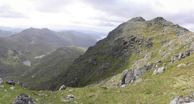
Garbh Chioch Mhòr (1013m) — "big rough hill" — is the immediate eastern neighbour of Sgùrr na Cìche and the two share one of the wildest ridge connections in Scotland: a rough rocky crest crossed by the famous old drystane dyke that runs along the high crest of the Rough Bounds of Knoydart. The two Munros are invariably climbed together, and most parties combine them with Sgùrr nan Coireachan to the east in a long three-Munro round from Strathan.
Gaelic: “rough, big” · Pronunciation: garrav chioch vore
Quick facts
- Height
- 1012.9m/ 3323ft
- Prominence
- 170 m
- Distance
- 17 km
- Ascent
- 891 m
- Time
- 5–8 hrs
- Grid ref
- NM909961
- Parking
- NM988914
- Nearest city
- Fort William· 29km
- Dogs
- Dogs on lead required near livestockDog-friendly guide ↗
Height and prominence cross-checked against the Database of British and Irish Hills (CC BY).
No GPX track yet
Walked this route? Share your track to help other walkers.
Standard route
Glen track 35% · Rocky ridge 40% · Summit 25%
From Strathan at the head of Loch Arkaig, walk west up Glen Dessarry on the long stalkers' path. Climb north onto the Bealach a' Mhàim, then west to Sgùrr na Cìche; descend back to the bealach and continue east-south-east along the rocky ridge to Garbh Chioch Mhòr — following the old drystane dyke for much of the way. Continue east to Sgùrr nan Coireachan and descend the south ridge back to Strathan. Around 23km with 1700m of ascent for the three Munros.
Terrain
The Glen Dessarry approach path alternates between well-built sections and rough, boggy patches. The connecting ridge from Sgùrr na Cìche to Garbh Chioch Mhòr is rough, rocky, undulating ground — much of it followed by the remarkable old drystane dyke that climbs up and over the crest. Hands-on scrambling at one or two points is helpful though not strictly required. The summit of Garbh Chioch Mhòr is a small rocky platform. The Sgùrr nan Coireachan link is broad easier walking.
In winter
A serious remote Knoydart winter day. The connecting ridges become genuine winter scrambles with cornicing on both sides. The Loch Arkaig road can drift; once on the hill there is no rescue infrastructure nearby. Phone signal absent throughout the day. SAIS Lochaber applies. Full alpine kit, careful daylight planning and self-sufficiency essential.
Best time of year
Getting there
- Glasgow3h 8m
- Edinburgh3h 29m
OS maps: OS Landranger 33, OS Landranger 40
Mobile signal: No signal in the Rough Bounds. Glen Dessarry and the Strathan road end are both without coverage. Download maps in Spean Bridge.
Current conditions
Daylight Today
- Sunrise
- 05:03
- Sunset
- 21:54
- Civil dawn
- 04:07
- Civil dusk
- 22:49
NOAA Solar Calculator · 23 July 2026
Pair with
Curated multi-hill combinations from Garbh Chioch Mhor.
Around Garbh Chioch Mhor on the SCOT network
Getting there, basing yourself, and what to do off the hill.
Getting there: Glenfinnan station
Glenfinnan Viaduct; Streap, Sgurr Thuilm, Glen Finnan Munros
15km from the hill
tripscot.co.uk
On TripSCOTBase yourself in Mallaig
Ferry port for Skye and the Small Isles; CWT finish supply
23km from the hill
tripscot.co.uk
On TasteSCOTAfter the hill: Ben Nevis Distillery
Fort William — Lochaber distillery at the foot of the Ben; long-aged Japanese-owned classics
29km from the hill
tastescot.co.uk
Garbh Chioch Mhor — common questions
- How difficult is Garbh Chioch Mhor?
- Garbh Chioch Mhor carries a 4/5 (challenging) grade on the OutdoorSCOT scale. Count on about 17km, 891m of ascent and a 5-8 hour day on the standard route. Terrain: The Glen Dessarry approach path alternates between well-built sections and rough, boggy patches.
- How prominent is Garbh Chioch Mhor?
- Garbh Chioch Mhor has 170m of topographic prominence — the height of its summit above the highest col connecting it to higher ground.
- Where should I park to climb Garbh Chioch Mhor?
- Standard parking is at NM988914. Check the parking grid reference on an OS map before travel; informal laybys can fill on summer weekends.
- When should I climb Garbh Chioch Mhor?
- The standard good-weather months for Garbh Chioch Mhor are May, June, July, August, September. Outside those months, expect winter conditions on the high ground — full mountain kit, navigation skills, and a check of the SAIS avalanche forecast for the relevant region.
- Can I bring my dog up Garbh Chioch Mhor?
- On a lead only — the route crosses ground with livestock or nesting-bird interest.
- What's mobile reception like on Garbh Chioch Mhor?
- No signal in the Rough Bounds. Glen Dessarry and the Strathan road end are both without coverage. Download maps in Spean Bridge.
- Is Garbh Chioch Mhor safe in winter?
- A serious remote Knoydart winter day. The connecting ridges become genuine winter scrambles with cornicing on both sides. The Loch Arkaig road can drift; once on the hill there is no rescue infrastructure nearby. Phone signal absent throughout the day. SAIS Lochaber applies. Full alpine kit, careful daylight planning and self-sufficiency essential.
Get the OutdoorSCOT weekly
One email a week — new route, hill and bothy guides, seasonal conditions and the odd hard-won lesson. No spam, unsubscribe in one click.