Corbett · Knoydart
Beinn an Aodainn (Ben Aden)
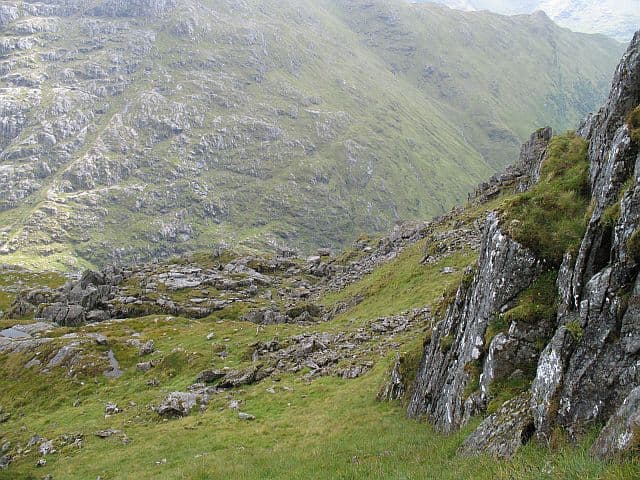
Ben Aden is the wild Corbett of Knoydart's northern edge — a rough, rocky hill standing between Loch Quoich and the head of Loch Nevis with no easy approach from any direction. The name comes from the Gaelic for 'face' or 'expression', apt for a mountain whose multiple ridges and corries give it a brooding, animated profile. The combination of remoteness, rough terrain and the need to wade or wait for the Loch Quoich water levels makes Ben Aden amongst the most committing single-day Corbetts in Scotland. Most parties walk in to Sourlies bothy and tackle it from there.
Quick facts
- Height
- 887m/ 2910ft
- Prominence
- 251 m
- Distance
- 30 km
- Ascent
- 1300 m
- Time
- 11–16 hrs
- Grid ref
- NM899986
- Parking
- NN071995
- Nearest city
- Fort William· 32km
- Dogs
- Dogs on lead required near livestockDog-friendly guide ↗
Height and prominence cross-checked against the Database of British and Irish Hills (CC BY).
No GPX track yet
Walked this route? Share your track to help other walkers.
Standard route
loch-side track 25% · rough heather 40% · rocky slopes 25% · summit ridge 10%
There is no straightforward route. The cleanest single-day line is from the Loch Quoich dam (NN071995), following the loch-side path west for around 7km to the head of the loch, then climbing south-west onto Ben Aden's eastern ridges. A second option is from Sourlies bothy on Loch Nevis (reached from Loch Arkaig via Glen Dessarry, two days in), climbing direct from the bothy. Wade or pick lines carefully around peat hags. Allow 11–13 hours for the single-day approach from Loch Quoich.
Terrain
Loch-side track in for the first part; beyond that, trackless rough Knoydart ground — heather, slabs, peat hags and exposed rock outcrops. Several minor stream crossings, all of which become serious in heavy rain. The summit ridges are firm rock but route-finding in cloud is genuinely difficult.
In winter
Ben Aden in winter is a major undertaking. The long approach, the lack of phone signal, the route-finding complexity in snow and the short daylight at this latitude combine into an expedition that should be planned over two days minimum with a bothy or bivouac base. Best left to experienced winter mountaineers in settled conditions.
Best time of year
Getting there
- Glasgow3h 11m
- Edinburgh4h 32m
OS maps: OS Landranger 33, OS Landranger 40
Mobile signal: No signal anywhere on the approach or on the hill — among the most remote terrestrial blackspots in Britain. PLB or satellite messenger strongly recommended
Current conditions
Daylight Today
- Sunrise
- 04:46
- Sunset
- 22:09
- Civil dawn
- 03:45
- Civil dusk
- 23:10
NOAA Solar Calculator · 13 July 2026
Pair with
Curated multi-hill combinations from Beinn an Aodainn (Ben Aden).
Around Beinn an Aodainn (Ben Aden) on the SCOT network
Getting there, basing yourself, and what to do off the hill.
Beinn an Aodainn (Ben Aden) — common questions
- What difficulty is Beinn an Aodainn (Ben Aden)?
- On the OutdoorSCOT scale, Beinn an Aodainn (Ben Aden) comes in at 5/5 — very challenging. Expect roughly 30km and 1300m of ascent on the usual route — 11-16 hours for most parties. Ground conditions: Loch-side track in for the first part; beyond that, trackless rough Knoydart ground — heather, slabs, peat hags and exposed rock outcrops.
- How much drop does Beinn an Aodainn (Ben Aden) have?
- The drop is 251m: measured from the summit of Beinn an Aodainn (Ben Aden) down to the saddle joining it to higher terrain.
- Where's the parking for Beinn an Aodainn (Ben Aden)?
- Park at NN071995. Double-check the grid reference on an OS map first; informal laybys here fill early in high season.
- What's the best month to climb Beinn an Aodainn (Ben Aden)?
- Aim for May, June, July, August, September on Beinn an Aodainn (Ben Aden). In the remaining months treat it as a winter hill — full kit, solid navigation, and a look at the relevant SAIS avalanche forecast before you go.
- Can dogs go up Beinn an Aodainn (Ben Aden)?
- Dogs are fine on a lead. The route passes livestock or ground-nesting bird habitat, so keep them close throughout.
- Will I get phone signal on Beinn an Aodainn (Ben Aden)?
- No signal anywhere on the approach or on the hill — among the most remote terrestrial blackspots in Britain. PLB or satellite messenger strongly recommended
- Is Beinn an Aodainn (Ben Aden) safe in winter?
- Ben Aden in winter is a major undertaking. The long approach, the lack of phone signal, the route-finding complexity in snow and the short daylight at this latitude combine into an expedition that should be planned over two days minimum with a bothy or bivouac base. Best left to experienced winter mountaineers in settled conditions.
Get the OutdoorSCOT weekly
One email a week — new route, hill and bothy guides, seasonal conditions and the odd hard-won lesson. No spam, unsubscribe in one click.