Munro · Kintail
Sgurr na Ciche
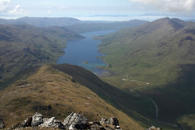
Sgùrr na Cìche (1040m) — "peak of the breast" — is one of the most iconic peaks in the Western Highlands, a perfect rocky cone forming the northern bastion of the Rough Bounds of Knoydart between Glen Dessarry and Loch Nevis. Its instantly-recognisable pointed profile is visible from as far away as Eigg, Skye and the Outer Hebrides. The hill is one of the more remote Munros, with no public road within 10km of the summit; access is either a long walk from Glen Dessarry or by boat to Inverie.
Gaelic: “sharp peak, of the, breast” · Pronunciation: skoor na kee-cha
Quick facts
- Height
- 1040.2m/ 3413ft
- Prominence
- 839 m
- Grid ref
- NM902966
- Parking
- NM988914
- Nearest city
- Fort William· 30km
- Dogs
- Dogs on lead required near livestockDog-friendly guide ↗
Height and prominence cross-checked against the Database of British and Irish Hills (CC BY).
No GPX track yet
Walked this route? Share your track to help other walkers.
Standard route
Glen track 35% · Open hillside / ridge 30% · Summit scramble 35%
The standard approach is from Strathan at the head of Loch Arkaig — already a 25-mile single-track drive from Spean Bridge. Walk west up Glen Dessarry on the rough stalkers' path past the Streaps, then climb north into the Bealach a' Mhàim. From the bealach turn west up the steep east ridge of Sgùrr na Cìche, with an exposed but straightforward rock step near the top. Often combined with Garbh Chioch Mhòr to the east. Around 22km with 1300m of ascent — a long, committing day.
Terrain
The Glen Dessarry stalkers' path is excellent in places, rough and boggy in others. The climb to the Bealach a' Mhàim is sustained on grass and broken rock. The east ridge of Sgùrr na Cìche is a fine pointed line with a rocky step near the summit that requires a hand on rock — exposed in places but not technically hard. The summit itself is a small rocky platform with a tiny cairn. The connecting ridge east to Garbh Chioch Mhòr crosses an old drystane dyke and is mostly rocky.
In winter
A serious remote winter mountaineering objective. The east ridge becomes a Grade I winter scramble; the summit pyramid in full winter conditions is a significant route. The Bealach a' Mhàim collects deep wind-blown snow. The Loch Arkaig road can be drifted closed and there is no rescue infrastructure for many kilometres. Phone signal absent throughout. SAIS Lochaber applies. Full alpine kit, daylight planning and self-sufficiency essential.
Best time of year
Getting there
- Glasgow3h 9m
- Edinburgh4h 30m
Ferry access
Mallaig → Inverie (Knoydart)
- Crossing time45 min
- Summer sailingsMon–Sat, 2–3 sailings daily (Apr–Oct, Western Isles Cruises)
- Winter sailingsMon/Wed/Fri only (Nov–Mar)
- Book ahead3 days
- Last ferry backLast ferry from Inverie ~17:30 (check Western Isles Cruises timetable)
Knoydart is a roadless peninsula — not an island, but accessible only by ferry or a very long walk (18+ km over difficult terrain). Day trips to Sgùrr Coire Choinnichean are achievable in summer. For Ladhar Bheinn, base yourself overnight at Inverie.
Book on ferry operator ↗OS maps: OS Landranger 33, OS Landranger 40
Mobile signal: No signal in the Rough Bounds of Knoydart. The approach from Strathan at the head of Loch Arkaig has no coverage. Grab maps before departing Spean Bridge.
Current conditions
Daylight Today
- Sunrise
- 05:03
- Sunset
- 21:54
- Civil dawn
- 04:07
- Civil dusk
- 22:49
NOAA Solar Calculator · 23 July 2026
Pair with
Curated multi-hill combinations from Sgurr na Ciche.
Around Sgurr na Ciche on the SCOT network
Getting there, basing yourself, and what to do off the hill.
Sgurr na Ciche — common questions
- How difficult is Sgurr na Ciche?
- Sgurr na Ciche carries a 4/5 (challenging) grade on the OutdoorSCOT scale. Terrain: The Glen Dessarry stalkers' path is excellent in places, rough and boggy in others.
- How prominent is Sgurr na Ciche?
- Sgurr na Ciche has 839m of topographic prominence — the height of its summit above the highest col connecting it to higher ground.
- Where should I park to climb Sgurr na Ciche?
- Standard parking is at NM988914. Check the parking grid reference on an OS map before travel; informal laybys can fill on summer weekends.
- When should I climb Sgurr na Ciche?
- The standard good-weather months for Sgurr na Ciche are May, June, July, August, September. Outside those months, expect winter conditions on the high ground — full mountain kit, navigation skills, and a check of the SAIS avalanche forecast for the relevant region.
- Can I bring my dog up Sgurr na Ciche?
- On a lead only — the route crosses ground with livestock or nesting-bird interest.
- What's mobile reception like on Sgurr na Ciche?
- No signal in the Rough Bounds of Knoydart. The approach from Strathan at the head of Loch Arkaig has no coverage. Grab maps before departing Spean Bridge.
- How do I get the ferry to Sgurr na Ciche?
- Mallaig → Inverie (Knoydart). Mon–Sat, 2–3 sailings daily (Apr–Oct, Western Isles Cruises) in summer; Mon/Wed/Fri only (Nov–Mar) in winter. Book at least 3 days ahead. Knoydart is a roadless peninsula — not an island, but accessible only by ferry or a very long walk (18+ km over difficult terrain). Day trips to Sgùrr Coire Choinnichean are achievable in summer. For Ladhar Bheinn, base yourself overnight at Inverie.
- Is Sgurr na Ciche safe in winter?
- A serious remote winter mountaineering objective. The east ridge becomes a Grade I winter scramble; the summit pyramid in full winter conditions is a significant route. The Bealach a' Mhàim collects deep wind-blown snow. The Loch Arkaig road can be drifted closed and there is no rescue infrastructure for many kilometres. Phone signal absent throughout. SAIS Lochaber applies. Full alpine kit, daylight planning and self-sufficiency essential.
Get the OutdoorSCOT weekly
One email a week — new route, hill and bothy guides, seasonal conditions and the odd hard-won lesson. No spam, unsubscribe in one click.