Corbett · Knoydart
Sgurr nan Eugallt
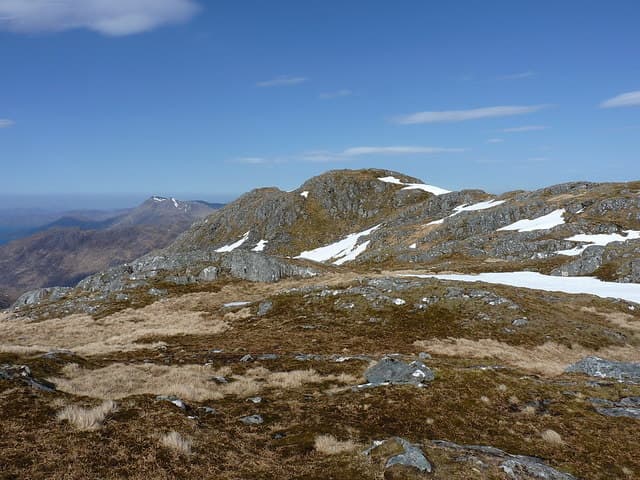
Sgùrr nan Eugallt — 'peak of the deadly streams' — is the Corbett guarding the eastern edge of Knoydart above Loch Quoich, a rough rocky peak with a high prominence that makes it stand apart from its better-known Munro neighbours. The 898m summit looks south-west into the heart of Knoydart toward Ladhar Bheinn and Luinne Bheinn, and the approach from Kinloch Hourn is one of the wilder walk-ins in the western Highlands. A serious day in country that rewards confident navigation.
Quick facts
- Height
- 897.5m/ 2945ft
- Prominence
- 612 m
- Distance
- 22 km
- Ascent
- 1100 m
- Time
- 7–11 hrs
- Grid ref
- NG927048
- Parking
- NG949068
- Nearest city
- Fort William· 36km
- Dogs
- Dogs on lead required near livestockDog-friendly guide ↗
Height and prominence cross-checked against the Database of British and Irish Hills (CC BY).
No GPX track yet
Walked this route? Share your track to help other walkers.
Standard route
coastal track 20% · steep grass 30% · rocky scramble 35% · summit ridge 15%
Park at the road end at Kinloch Hourn (NG949068). Walk south-west along the coastal path for around 5km to Barrisdale Bay, then turn inland up the Mam Barrisdale path. Around halfway up the bealach, leave the path and climb north-east up rough grass onto Sgùrr nan Eugallt's broad south ridge. The route gains a series of subsidiary tops before reaching the summit cairn. Allow 9–10 hours.
Terrain
Coastal path from Kinloch Hourn is rough but well-defined. Above Barrisdale, the going turns to steep grass and rock outcrops with no real path. The summit ridge has several knolls and small tops; in cloud, choosing the right one for descent matters. Watch for the deeply incised streams that give the hill its name — they appear suddenly and several have produced injuries to walkers attempting to ford in spate.
In winter
In winter Sgùrr nan Eugallt is a serious far-west objective. The Kinloch Hourn road can drift in heavy storms, the coastal path ices up, and the upper hill holds wind slab in lee aspects. Most parties tackle this as a multi-day Knoydart traverse with bothy bases at Barrisdale or Sourlies.
Best time of year
Getting there
- Glasgow3h 58m
- Edinburgh4h 35m
OS maps: OS Landranger 33
Mobile signal: No signal — Knoydart/Loch Hourn area, completely remote from the network
Current conditions
Daylight Today
- Sunrise
- 04:46
- Sunset
- 22:09
- Civil dawn
- 03:44
- Civil dusk
- 23:11
NOAA Solar Calculator · 13 July 2026
Pair with
Curated multi-hill combinations from Sgurr nan Eugallt.
Around Sgurr nan Eugallt on the SCOT network
Getting there, basing yourself, and what to do off the hill.
Sgurr nan Eugallt — common questions
- How difficult is Sgurr nan Eugallt?
- Sgurr nan Eugallt carries a 4/5 (challenging) grade on the OutdoorSCOT scale. Count on about 22km, 1100m of ascent and a 7-11 hour day on the standard route. Ground conditions: Coastal path from Kinloch Hourn is rough but well-defined.
- How much drop does Sgurr nan Eugallt have?
- The drop is 612m: measured from the summit of Sgurr nan Eugallt down to the saddle joining it to higher terrain.
- Where's the parking for Sgurr nan Eugallt?
- Park at NG949068. Double-check the grid reference on an OS map first; informal laybys here fill early in high season.
- What's the best month to climb Sgurr nan Eugallt?
- Aim for May, June, July, August, September on Sgurr nan Eugallt. In the remaining months treat it as a winter hill — full kit, solid navigation, and a look at the relevant SAIS avalanche forecast before you go.
- Can dogs go up Sgurr nan Eugallt?
- Dogs are fine on a lead. The route passes livestock or ground-nesting bird habitat, so keep them close throughout.
- Will I get phone signal on Sgurr nan Eugallt?
- No signal — Knoydart/Loch Hourn area, completely remote from the network
- Is Sgurr nan Eugallt safe in winter?
- In winter Sgùrr nan Eugallt is a serious far-west objective. The Kinloch Hourn road can drift in heavy storms, the coastal path ices up, and the upper hill holds wind slab in lee aspects. Most parties tackle this as a multi-day Knoydart traverse with bothy bases at Barrisdale or Sourlies.
Get the OutdoorSCOT weekly
One email a week — new route, hill and bothy guides, seasonal conditions and the odd hard-won lesson. No spam, unsubscribe in one click.