Corbett · Knoydart
Beinn nan Caorach
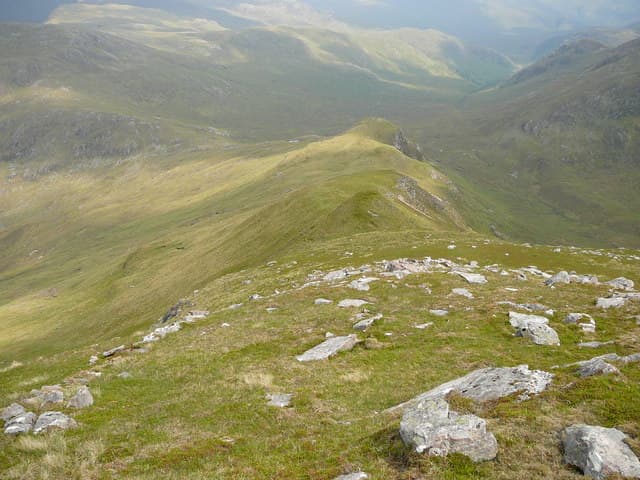
Beinn nan Caorach — "hill of the sheep" — is a 774m Corbett in the Glenelg hills above the Sound of Sleat, looking across to Skye. The hill sits north of Glen Beag and forms part of the long ridge above Loch Hourn that includes the Munro Beinn Sgritheall to the north-west. A small cairn marks the wide grassy summit dome, looking out across the Sound of Sleat to Skye and south to Knoydart with one of the finest mainland views available from any mainland Corbett.
Quick facts
- Height
- 774m/ 2539ft
- Prominence
- 227 m
- Distance
- 14 km
- Ascent
- 635 m
- Time
- 4–7 hrs
- Grid ref
- NG871121
- Parking
- NG818178
- Nearest city
- Fort William· 45km
- Dogs
- Dogs on lead required near livestockDog-friendly guide ↗
Height and prominence cross-checked against the Database of British and Irish Hills (CC BY).
No GPX track yet
Walked this route? Share your track to help other walkers.
Standard route
glen path 25% · open hillside 35% · broad dome 30% · summit cairn 10%
Park at the small lay-by near Eilanreach in Glen Beag, on the Glenelg-to-Arnisdale road, and follow the public path north-east up the glen. After roughly 3km, climb open grass and heather slopes south onto the broad north ridge of Beinn nan Caorach. An easy pull up the ridge reaches the summit. Roughly 14km out-and-back with 635m of climbing. Often combined with Beinn na h-Eaglaise across the bealach for a Glenelg pair-day.
Terrain
The Glen Beag path is firm peat to its end. Off the path the slopes are short heather and grass — comfortable underfoot with neither scrambling nor exposure. The summit dome is broad short turf and the cairn marks the highest point. Glen Beag contains the famous Glenelg brochs, worth a visit on the way in.
In winter
A welcoming winter hill — easy gradients, no significant avalanche slopes, and a manageable approach from Glenelg. The single-track road over Mam Ratagan from Shiel Bridge can be slow in heavy snow; the Glenelg ferry is seasonal and not relevant in winter. Cornicing forms on the east side of the summit ridge after south-westerly winds.
Best time of year
Getting there
- Glasgow3h 8m
- Edinburgh4h 45m
OS maps: OS Landranger 33
Mobile signal: Reasonable signal in Glenelg; nothing higher up
Current conditions
Daylight Today
- Sunrise
- 04:52
- Sunset
- 22:05
- Civil dawn
- 03:53
- Civil dusk
- 23:04
NOAA Solar Calculator · 17 July 2026
Around Beinn nan Caorach on the SCOT network
Getting there, basing yourself, and what to do off the hill.
Beinn nan Caorach — common questions
- How difficult is Beinn nan Caorach?
- Beinn nan Caorach carries a 2/5 (moderate) grade on the OutdoorSCOT scale. Count on about 14km, 635m of ascent and a 4-7 hour day on the standard route. Underfoot: The Glen Beag path is firm peat to its end.
- What is Beinn nan Caorach's prominence?
- 227m of prominence. That's the vertical drop from the summit to the col that links Beinn nan Caorach to the next higher ground.
- Where do I park for Beinn nan Caorach?
- Most walkers start from NG818178. Verify the grid reference on an OS map before you set off — space is tight on busy summer weekends.
- When is the best time to climb Beinn nan Caorach?
- May, June, July, August, September give the most reliable conditions on Beinn nan Caorach. Beyond that window the high ground turns wintry: carry full mountain kit, be confident navigating, and check the SAIS avalanche forecast for the area.
- Is Beinn nan Caorach dog-friendly?
- Yes, but dogs must be kept on a lead — there is livestock or ground-nesting bird interest on the route.
- Is there mobile signal on Beinn nan Caorach?
- Reasonable signal in Glenelg; nothing higher up
- Is Beinn nan Caorach safe in winter?
- A welcoming winter hill — easy gradients, no significant avalanche slopes, and a manageable approach from Glenelg. The single-track road over Mam Ratagan from Shiel Bridge can be slow in heavy snow; the Glenelg ferry is seasonal and not relevant in winter. Cornicing forms on the east side of the summit ridge after south-westerly winds.
Get the OutdoorSCOT weekly
One email a week — new route, hill and bothy guides, seasonal conditions and the odd hard-won lesson. No spam, unsubscribe in one click.