Graham · Kintail
Beinn Clachach
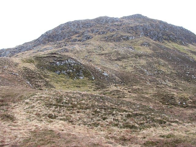
Beinn Clachach (642m) — the stony hill — is a rough Lochalsh top in the NG81 square, looking north over the Sound of Sleat toward Knoydart. The summit pairing of rock and small cairn sits above Loch nan Eun, with views west to Skye that include the Cuillin on a clear day.
Quick facts
- Height
- 642.3m/ 2107ft
- Prominence
- 228 m
- Distance
- 12 km
- Ascent
- 482 m
- Time
- 3–5 hrs
- Grid ref
- NG885109
- Parking
- NG846119
- Nearest city
- Fort William· 43km
- Dogs
- Dogs on lead required near livestockDog-friendly guide ↗
Height and prominence cross-checked against the Database of British and Irish Hills (CC BY).
No GPX track yet
Walked this route? Share your track to help other walkers.
Standard route
heather moorland 65% · grass slopes 25% · rocky summit 10%
Start from the lay-by north of Arnisdale on the minor road into Coire-shubh. Follow the estate path east up the burn, then strike north onto the open hillside past Loch nan Eun. Rough heather and boulder fields lead onto the south spur and so to the rocky summit beside the cairn.
Terrain
Estate path then trackless boulder-strewn heather above Loch nan Eun. The south spur has chunky Lewisian gneiss underfoot — slow going but secure. The cairn and rock pair are easily found in clear weather.
In winter
Arnisdale catches huge sea-level rainfall that turns to snow quickly above 400m. Beinn Clachach's boulder-fields ice over and become awkward to traverse without spikes. The road is single-track and seldom gritted, so winter access is the bigger problem than the hill itself.
Best time of year
Getting there
- Glasgow3h 6m
- Edinburgh4h 43m
OS maps: OS Landranger 33
Mobile signal: Poor. Remote Arnisdale / Sound of Sleat coast; weak on all networks.
Current conditions
Daylight Today
- Sunrise
- 04:52
- Sunset
- 22:04
- Civil dawn
- 03:53
- Civil dusk
- 23:04
NOAA Solar Calculator · 17 July 2026
Around Beinn Clachach on the SCOT network
Getting there, basing yourself, and what to do off the hill.
Beinn Clachach — common questions
- How difficult is Beinn Clachach?
- Beinn Clachach carries a 3/5 (moderately challenging) grade on the OutdoorSCOT scale. Count on about 12km, 482m of ascent and a 3-5 hour day on the standard route. Underfoot: Estate path then trackless boulder-strewn heather above Loch nan Eun.
- What is Beinn Clachach's prominence?
- 228m of prominence. That's the vertical drop from the summit to the col that links Beinn Clachach to the next higher ground.
- Where do I park for Beinn Clachach?
- Most walkers start from NG846119. Verify the grid reference on an OS map before you set off — space is tight on busy summer weekends.
- When is the best time to climb Beinn Clachach?
- May, June, July, August, September give the most reliable conditions on Beinn Clachach. Beyond that window the high ground turns wintry: carry full mountain kit, be confident navigating, and check the SAIS avalanche forecast for the area.
- Is Beinn Clachach dog-friendly?
- Yes, but dogs must be kept on a lead — there is livestock or ground-nesting bird interest on the route.
- Is there mobile signal on Beinn Clachach?
- Poor. Remote Arnisdale / Sound of Sleat coast; weak on all networks.
- Is Beinn Clachach safe in winter?
- Arnisdale catches huge sea-level rainfall that turns to snow quickly above 400m. Beinn Clachach's boulder-fields ice over and become awkward to traverse without spikes. The road is single-track and seldom gritted, so winter access is the bigger problem than the hill itself.
Get the OutdoorSCOT weekly
One email a week — new route, hill and bothy guides, seasonal conditions and the odd hard-won lesson. No spam, unsubscribe in one click.