Graham · Kintail
Druim Fada
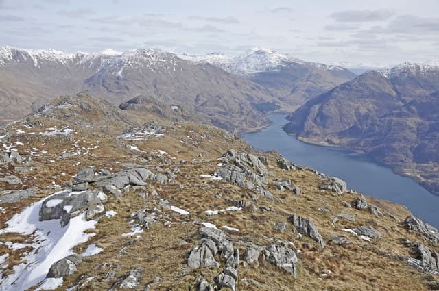
Druim Fada (710m) — the long ridge — at NG89 forms the spine of the Glenelg peninsula opposite Skye, separating Loch Hourn from the Sound of Sleat. The two-summit ridge gives a striking sea view: the Knoydart skyline to the south, the entire Cuillin to the west, and the Five Sisters of Kintail eastward across Glen More. Beorus Hill (the eastern Marilyn) is the high point of the ridge proper.
Gaelic: “ridge, long” · Pronunciation: drim fah-dah
Quick facts
- Height
- 710.7m/ 2332ft
- Prominence
- 484 m
- Distance
- 13 km
- Ascent
- 582 m
- Time
- 4–6 hrs
- Grid ref
- NG894083
- Parking
- NG926091
- Nearest city
- Fort William· 40km
- Dogs
- Dogs on lead required near livestockDog-friendly guide ↗
Height and prominence cross-checked against the Database of British and Irish Hills (CC BY).
No GPX track yet
Walked this route? Share your track to help other walkers.
Standard route
heather moorland 50% · bog and wet grass 30% · rocky outcrops 20%
From the public parking at NG926091 near Bernera, climb steeply north-west onto the ridge crest, then traverse the entire spine. The long roof-like undulation gives surprisingly fast progress on short turf once the initial climb is done. Around 13km with 582m of cumulative ascent on the full ridge, returning by the same line or descending to Glenelg village.
Terrain
The initial pull through bracken and boulder is the only stiff section. Above 400m the ridge is cropped turf and lichen-spotted rock, with several bog hollows between the tops to slow walkers in wet weather. Cliffs fall steeply north toward Glenelg Bay — keep south of the crest in poor visibility.
In winter
Cold Atlantic systems hit the Glenelg coast hard, with sustained 70mph westerlies in winter storms not unusual. The ridge collects deep lee snow on north-facing aspects. SAIS Northern Highlands covers the Cluanie and Affric area immediately to the east and gives useful context. Short December daylight here is around seven hours.
Best time of year
Getting there
- Glasgow3h 3m
- Edinburgh4h 40m
OS maps: OS Landranger 33
Mobile signal: Patchy signal. O2 occasionally picks up near ridge crest; otherwise poor.
Current conditions
Daylight Today
- Sunrise
- 04:52
- Sunset
- 22:04
- Civil dawn
- 03:53
- Civil dusk
- 23:03
NOAA Solar Calculator · 17 July 2026
Around Druim Fada on the SCOT network
Getting there, basing yourself, and what to do off the hill.
Druim Fada — common questions
- How difficult is Druim Fada?
- Druim Fada carries a 2/5 (moderate) grade on the OutdoorSCOT scale. Count on about 13km, 582m of ascent and a 4-6 hour day on the standard route. Ground conditions: The initial pull through bracken and boulder is the only stiff section.
- How much drop does Druim Fada have?
- The drop is 484m: measured from the summit of Druim Fada down to the saddle joining it to higher terrain.
- Where's the parking for Druim Fada?
- Park at NG926091. Double-check the grid reference on an OS map first; informal laybys here fill early in high season.
- What's the best month to climb Druim Fada?
- Aim for May, June, July, August, September on Druim Fada. In the remaining months treat it as a winter hill — full kit, solid navigation, and a look at the relevant SAIS avalanche forecast before you go.
- Can dogs go up Druim Fada?
- Dogs are fine on a lead. The route passes livestock or ground-nesting bird habitat, so keep them close throughout.
- Will I get phone signal on Druim Fada?
- Patchy signal. O2 occasionally picks up near ridge crest; otherwise poor.
- Is Druim Fada safe in winter?
- Cold Atlantic systems hit the Glenelg coast hard, with sustained 70mph westerlies in winter storms not unusual. The ridge collects deep lee snow on north-facing aspects. SAIS Northern Highlands covers the Cluanie and Affric area immediately to the east and gives useful context. Short December daylight here is around seven hours.
Get the OutdoorSCOT weekly
One email a week — new route, hill and bothy guides, seasonal conditions and the odd hard-won lesson. No spam, unsubscribe in one click.