Munro · Kintail
The Saddle
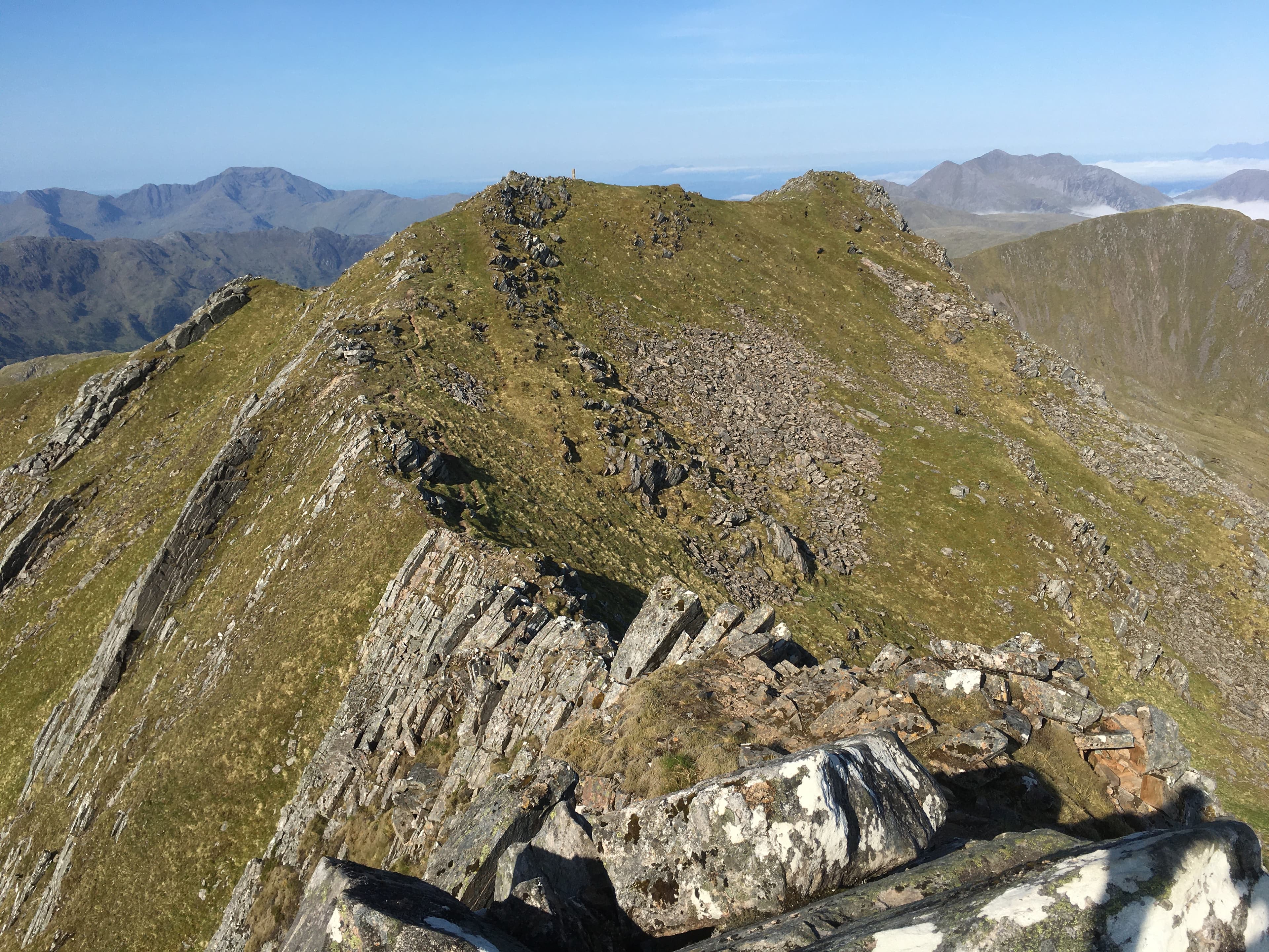
The Saddle (1011m) is one of the most distinctive Munros in Kintail, the steep multi-pinnacled peak west of the South Glen Shiel Ridge. The hill is celebrated for the Forcan Ridge — a sharp, narrow east ridge giving one of the great Scottish ridge scrambles at Grade 3. The summit area has two close tops (Trig Point at 1010m and the slightly higher main summit at 1011m). Views from the top extend across to Skye, the Five Sisters, Knoydart and the South Glen Shiel ridge.
Quick facts
- Height
- 1011.5m/ 3319ft
- Prominence
- 334 m
- Distance
- 13 km
- Ascent
- 1350 m
- Time
- 6–8 hrs
- Grid ref
- NG936131
- Parking
- NG967143
- Nearest city
- Fort William· 43km
- Dogs
- Dogs on lead required near livestockDog-friendly guide ↗
Height and prominence cross-checked against the Database of British and Irish Hills (CC BY).
No GPX track yet
Walked this route? Share your track to help other walkers.
Standard route
Glen path 30% · Forcan Ridge scramble 40% · Summit / descent ridge 30%
Park at the small Achnangart lay-by on the A87, west of Cluanie. Take the stalkers' path south up Coire na Cadha to the Bealach Coire Mhalagain, then turn west onto the Forcan Ridge — a sustained Grade 3 scramble for 1km with several airy moves. A bypass path avoids the hardest sections on the south side but misses the best terrain. From the summit, descend the broad west ridge to Sgurr nan Forcan, then back to Glen Shiel. Around 13km with 1350m of ascent for the usual round with Sgurr na Sgine.
Terrain
The Coire na Cadha stalkers' path is well-built pitching for the first kilometre. The Forcan Ridge is sustained Grade 3 scrambling on clean, exposed rock with multiple airy moves — committing for the level of difficulty and avoided in wet conditions. The bypass path on the south side is steep loose scree. The summit area has the trig pillar a few metres west of the slightly higher main summit. Descent via the broad west ridge is straightforward.
In winter
A major Scottish winter mountaineering objective. The Forcan Ridge in winter becomes a serious technical Grade III mountaineering route — committing and exposed. The bypass path becomes steep avalanche-prone snow. The Coire na Cadha bealach holds significant avalanche risk after westerly storms. The A87 corridor is gritted; the Achnangart lay-by is reliable. Phone signal absent above 600m. SAIS Northern Highlands applies. Full alpine kit and competence essential.
Best time of year
Getting there
- Glasgow3h 6m
- Edinburgh4h 41m
OS maps: OS Landranger 33
Mobile signal: Moderate signal at Shiel Bridge on the A87. Signal absent above 600m. Very remote area west of Cluanie.
Current conditions
Daylight Today
- Sunrise
- 05:02
- Sunset
- 21:54
- Civil dawn
- 04:06
- Civil dusk
- 22:51
NOAA Solar Calculator · 23 July 2026
Pair with
Curated multi-hill combinations from The Saddle.
Around The Saddle on the SCOT network
Getting there, basing yourself, and what to do off the hill.
The Saddle — common questions
- Is The Saddle a hard climb?
- The Saddle is rated 5/5 (very challenging) on the OutdoorSCOT scale. The standard route covers about 13km with 1350m of ascent and takes most walkers 6-8 hours. Terrain: The Coire na Cadha stalkers' path is well-built pitching for the first kilometre.
- How prominent is The Saddle?
- The Saddle has 334m of topographic prominence — the height of its summit above the highest col connecting it to higher ground.
- Where should I park to climb The Saddle?
- Standard parking is at NG967143. Check the parking grid reference on an OS map before travel; informal laybys can fill on summer weekends.
- When should I climb The Saddle?
- The standard good-weather months for The Saddle are May, June, July, August, September. Outside those months, expect winter conditions on the high ground — full mountain kit, navigation skills, and a check of the SAIS avalanche forecast for the relevant region.
- Can I bring my dog up The Saddle?
- On a lead only — the route crosses ground with livestock or nesting-bird interest.
- What's mobile reception like on The Saddle?
- Moderate signal at Shiel Bridge on the A87. Signal absent above 600m. Very remote area west of Cluanie.
- Is The Saddle safe in winter?
- A major Scottish winter mountaineering objective. The Forcan Ridge in winter becomes a serious technical Grade III mountaineering route — committing and exposed. The bypass path becomes steep avalanche-prone snow. The Coire na Cadha bealach holds significant avalanche risk after westerly storms. The A87 corridor is gritted; the Achnangart lay-by is reliable. Phone signal absent above 600m. SAIS Northern Highlands applies. Full alpine kit and competence essential.
Get the OutdoorSCOT weekly
One email a week — new route, hill and bothy guides, seasonal conditions and the odd hard-won lesson. No spam, unsubscribe in one click.