Corbett · Glen Shiel
Sgurr Mhic Bharraich
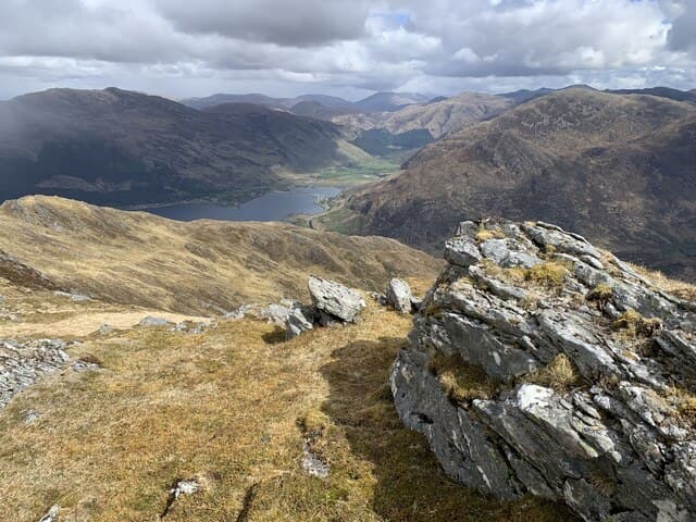
Sgùrr Mhic Bharraich is the rocky 779m Corbett rising at the head of Glen Shiel directly opposite the Saddle, accessed from Shiel Bridge. The mountain is overshadowed by the great Kintail Munros to the north — the Five Sisters, the Saddle, the South Glen Shiel ridge — but gives a satisfying short Corbett day with a striking summit view directly across into the heart of the Saddle and along the line of the Forcan Ridge. A useful hill day when poor weather rules out the bigger Munros.
Gaelic: “sharp peak, son of” · Pronunciation: skoor mhic bharraich
Quick facts
- Height
- 779m/ 2556ft
- Prominence
- 317 m
- Distance
- 9 km
- Ascent
- 770 m
- Time
- 2–4 hrs
- Grid ref
- NG917173
- Parking
- NG937185
- Nearest city
- Fort William· 47km
- Dogs
- Dogs on lead required near livestockDog-friendly guide ↗
Height and prominence cross-checked against the Database of British and Irish Hills (CC BY).
No GPX track yet
Walked this route? Share your track to help other walkers.
Standard route
glen path 20% · steep grass 40% · rocky upper section 30% · summit area 10%
Park at the public car park in Shiel Bridge village (NG937185). Walk south on the minor road past the campsite, then take the path heading east-south-east up through Coire Mhicrolt. The path climbs through woodland and onto open hill, gaining the broad north ridge of Sgùrr Mhic Bharraich. A modest cairn marks the top, set on a rocky knob above the corrie. Allow 4–5 hours.
Terrain
Excellent stalkers' path through the lower corrie — well-built. The middle and upper section is grass and rock with small outcrops on the summit ridge. The cairn is small but the position above the corrie is striking. Easy descent on the same path.
In winter
Sgùrr Mhic Bharraich under snow gives a satisfying short winter day, the ascent route well away from avalanche-prone terrain. The Kintail SAIS bulletin covers conditions. Shiel Bridge stays accessible by car in most winters. The descent ices up readily on the pitched path — take care.
Best time of year
Getting there
- Glasgow3h 12m
- Edinburgh4h 46m
OS maps: OS Landranger 33
Mobile signal: No signal in Shiel Bridge/Glenelg area
Current conditions
Daylight Today
- Sunrise
- 04:45
- Sunset
- 22:10
- Civil dawn
- 03:43
- Civil dusk
- 23:12
NOAA Solar Calculator · 13 July 2026
Pair with
Curated multi-hill combinations from Sgurr Mhic Bharraich.
Around Sgurr Mhic Bharraich on the SCOT network
Getting there, basing yourself, and what to do off the hill.
Sgurr Mhic Bharraich — common questions
- How difficult is Sgurr Mhic Bharraich?
- Sgurr Mhic Bharraich carries a 2/5 (moderate) grade on the OutdoorSCOT scale. Count on about 9km, 770m of ascent and a 2-4 hour day on the standard route. Ground conditions: Excellent stalkers' path through the lower corrie — well-built.
- How much drop does Sgurr Mhic Bharraich have?
- The drop is 317m: measured from the summit of Sgurr Mhic Bharraich down to the saddle joining it to higher terrain.
- Where's the parking for Sgurr Mhic Bharraich?
- Park at NG937185. Double-check the grid reference on an OS map first; informal laybys here fill early in high season.
- What's the best month to climb Sgurr Mhic Bharraich?
- Aim for May, June, July, August, September on Sgurr Mhic Bharraich. In the remaining months treat it as a winter hill — full kit, solid navigation, and a look at the relevant SAIS avalanche forecast before you go.
- Can dogs go up Sgurr Mhic Bharraich?
- Dogs are fine on a lead. The route passes livestock or ground-nesting bird habitat, so keep them close throughout.
- Will I get phone signal on Sgurr Mhic Bharraich?
- No signal in Shiel Bridge/Glenelg area
- Is Sgurr Mhic Bharraich safe in winter?
- Sgùrr Mhic Bharraich under snow gives a satisfying short winter day, the ascent route well away from avalanche-prone terrain. The Kintail SAIS bulletin covers conditions. Shiel Bridge stays accessible by car in most winters. The descent ices up readily on the pitched path — take care.
Get the OutdoorSCOT weekly
One email a week — new route, hill and bothy guides, seasonal conditions and the odd hard-won lesson. No spam, unsubscribe in one click.