Corbett · Kintail
Sgurr an Airgid
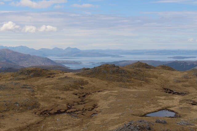
Sgurr an Airgid — "peak of silver" — rises directly out of Loch Duich on its north shore, opposite the famous Five Sisters of Kintail. At 841m the cone-shaped summit gives one of the most arresting views in the western Highlands: the full sweep of the Five Sisters at eye level across the loch, with the South Glen Shiel ridge stretching east and the peaks of Skye visible to the west. Its 394m of prominence comes from the deep cleft of Strath Croe to the north which separates it from the bigger Kintail hills.
Quick facts
- Height
- 841.2m/ 2760ft
- Prominence
- 394 m
- Distance
- 15 km
- Ascent
- 740 m
- Time
- 5–7 hrs
- Grid ref
- NG940227
- Parking
- NG891253
- Nearest
- Fort William· Inverness 76km
- Dogs
- Dogs on lead required near livestockDog-friendly guide ↗
Height and prominence cross-checked against the Database of British and Irish Hills (CC BY).
No GPX track yet
Walked this route? Share your track to help other walkers.
Standard route
stalkers zig-zags 55% · ridge walk 25% · rocky step 10% · summit cairn 10%
The standard line starts from Bundalloch at the head of Loch Duich, following the well-built stalkers path that climbs steeply up the south flank of the hill. The path reaches the summit ridge after roughly 600m of relentless zig-zags. From there a short easy walk leads east to the rocky summit. Around 15km return with 740m of ascent. The hill is normally a stand-alone day; the Five Sisters and Sgurr na Sgine are separate undertakings.
Terrain
The Bundalloch path is one of the best-built stalkers paths in Kintail — well drained and clear all the way to the ridge. The south face is unrelentingly steep, slippery in the wet on the lower bracken-covered sections. The summit ridge is broad short grass with one small rocky step before the cairn. No exposure on the standard line, though the north drop into Strath Croe is sudden.
In winter
A surprisingly serious winter Corbett — the steep south face becomes an avalanche slope after westerly storms and the zig-zag path can be hard to follow under snow. The summit ridge ices up readily. Loch Duich is rarely closed by snow but the A87 over the Glen Shiel pass can be slow. Most parties save Sgurr an Airgid for a clear spring day.
Best time of year
Getting there
- Glasgow3h 16m
- Edinburgh4h 49m
OS maps: OS Landranger 25, OS Landranger 33
Mobile signal: Reliable signal at Bundalloch / Dornie; reasonable on the summit
Current conditions
Daylight Today
- Sunrise
- 04:45
- Sunset
- 22:10
- Civil dawn
- 03:42
- Civil dusk
- 23:12
NOAA Solar Calculator · 13 July 2026
Pair with
Curated multi-hill combinations from Sgurr an Airgid.
On a long-distance route
Sgurr an Airgid sits within 5km of these named long-distance walks — useful for trail-pack rest days or section extensions.
Around Sgurr an Airgid on the SCOT network
Getting there, basing yourself, and what to do off the hill.
Sgurr an Airgid — common questions
- How difficult is Sgurr an Airgid?
- Sgurr an Airgid carries a 3/5 (moderately challenging) grade on the OutdoorSCOT scale. Count on about 15km, 740m of ascent and a 5-7 hour day on the standard route. Terrain: The Bundalloch path is one of the best-built stalkers paths in Kintail — well drained and clear all the way to the ridge.
- How prominent is Sgurr an Airgid?
- Sgurr an Airgid has 394m of topographic prominence — the height of its summit above the highest col connecting it to higher ground.
- Where should I park to climb Sgurr an Airgid?
- Standard parking is at NG891253 near Fort William. Check the parking grid reference on an OS map before travel; informal laybys can fill on summer weekends.
- When should I climb Sgurr an Airgid?
- The standard good-weather months for Sgurr an Airgid are May, June, July, August, September. Outside those months, expect winter conditions on the high ground — full mountain kit, navigation skills, and a check of the SAIS avalanche forecast for the relevant region.
- Can I bring my dog up Sgurr an Airgid?
- On a lead only — the route crosses ground with livestock or nesting-bird interest.
- What's mobile reception like on Sgurr an Airgid?
- Reliable signal at Bundalloch / Dornie; reasonable on the summit
- Is Sgurr an Airgid safe in winter?
- A surprisingly serious winter Corbett — the steep south face becomes an avalanche slope after westerly storms and the zig-zag path can be hard to follow under snow. The summit ridge ices up readily. Loch Duich is rarely closed by snow but the A87 over the Glen Shiel pass can be slow. Most parties save Sgurr an Airgid for a clear spring day.
Get the OutdoorSCOT weekly
One email a week — new route, hill and bothy guides, seasonal conditions and the odd hard-won lesson. No spam, unsubscribe in one click.