Corbett · Central Highlands
Faochaig
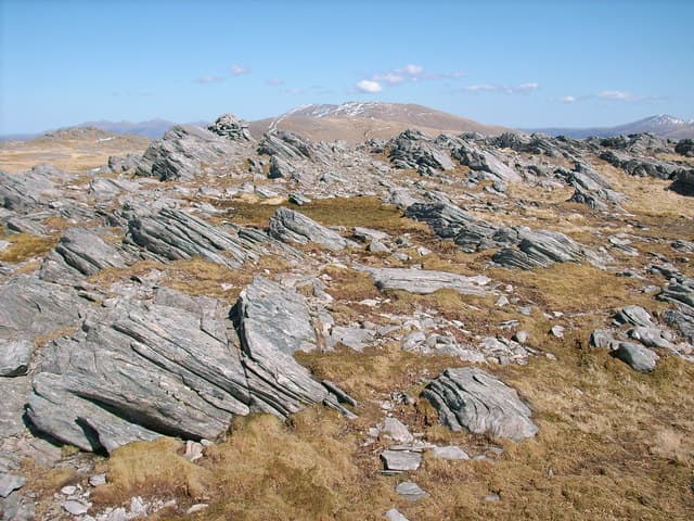
Faochaig is the 868m Corbett sitting west of Sguman Coinntich at the head of Glen Elchaig, near the bealach above the Falls of Glomach. The two hills form the natural Corbett pair of Glen Elchaig, climbed together by most parties on the same bike-in. The summit is small and rocky, with a low cairn beside an outcrop. The west-facing slopes drop dramatically toward the upper Glomach gorge — one of the deepest cleft in the Highlands.
Quick facts
- Height
- 868.9m/ 2851ft
- Prominence
- 231 m
- Distance
- 20 km
- Ascent
- 850 m
- Time
- 5–8 hrs
- Grid ref
- NH021317
- Parking
- NG937302
- Nearest
- Fort William· Inverness 66km
- Dogs
- Dogs on lead required near livestockDog-friendly guide ↗
Height and prominence cross-checked against the Database of British and Irish Hills (CC BY).
No GPX track yet
Walked this route? Share your track to help other walkers.
Standard route
glen track 30% · heather slope 40% · grassy ridge 20% · summit area 10%
Same start as Sguman Coinntich: Killilan road end (NG937302). Bike or walk Glen Elchaig east for around 6km, then climb south onto Faochaig's north flank. A steady ascent across grass and rough heather brings you to the summit ridge; the cairn sits beside a rock outcrop near the high point. For the pair, traverse east to Sguman Coinntich and descend back into Glen Elchaig. Allow 7–8 hours alone; 9–10 for the pair.
Terrain
Estate track on the long approach — quick on a bike. Beyond the track, the slope shifts into a mix of heather, grass and peat with a few rock outcrops on the upper section. The summit is small and rocky with a low cairn. The west side of the hill drops steeply toward the Falls of Glomach gorge; keep clear of the rim in cloud.
In winter
Winter access to Faochaig is constrained by the Killilan road conditions and bike-track icing in cold spells. Deep cover persists on the upper hill through the heart of winter. The standard north flank line carries no avalanche risk. The Falls of Glomach in full winter ice is a striking sight on the descent.
This hill is in the Creag Meagaidh SAIS forecast area. Check SAIS forecasts in winter (December–April).
Best time of year
Getting there
- Glasgow3h 23m
- Edinburgh4h 51m
OS maps: OS Landranger 25
Mobile signal: No reliable coverage along Glen Elchaig or on the approach from Killilan — the deep glen and surrounding ridges shadow all networks. Brief EE/Vodafone returns on the upper ridge with a line toward Loch Long. Treat the day as fully off-grid and carry paper maps.
Current conditions
Daylight Today
- Sunrise
- 04:43
- Sunset
- 22:10
- Civil dawn
- 03:41
- Civil dusk
- 23:13
NOAA Solar Calculator · 13 July 2026
Pair with
Curated multi-hill combinations from Faochaig.
Around Faochaig on the SCOT network
Getting there, basing yourself, and what to do off the hill.
Faochaig — common questions
- What difficulty is Faochaig?
- On the OutdoorSCOT scale, Faochaig comes in at 3/5 — moderately challenging. Expect roughly 20km and 850m of ascent on the usual route — 5-8 hours for most parties. Ground conditions: Estate track on the long approach — quick on a bike.
- How much drop does Faochaig have?
- The drop is 231m: measured from the summit of Faochaig down to the saddle joining it to higher terrain.
- Where's the parking for Faochaig?
- Park at NG937302 near Fort William. Double-check the grid reference on an OS map first; informal laybys here fill early in high season.
- What's the best month to climb Faochaig?
- Aim for May, June, July, August, September, October on Faochaig. In the remaining months treat it as a winter hill — full kit, solid navigation, and a look at the relevant SAIS avalanche forecast before you go.
- Can dogs go up Faochaig?
- Dogs are fine on a lead. The route passes livestock or ground-nesting bird habitat, so keep them close throughout.
- Will I get phone signal on Faochaig?
- No reliable coverage along Glen Elchaig or on the approach from Killilan — the deep glen and surrounding ridges shadow all networks. Brief EE/Vodafone returns on the upper ridge with a line toward Loch Long. Treat the day as fully off-grid and carry paper maps.
- Is Faochaig safe in winter?
- Winter access to Faochaig is constrained by the Killilan road conditions and bike-track icing in cold spells. Deep cover persists on the upper hill through the heart of winter. The standard north flank line carries no avalanche risk. The Falls of Glomach in full winter ice is a striking sight on the descent.
Get the OutdoorSCOT weekly
One email a week — new route, hill and bothy guides, seasonal conditions and the odd hard-won lesson. No spam, unsubscribe in one click.