Munro · Central Highlands
An Socach
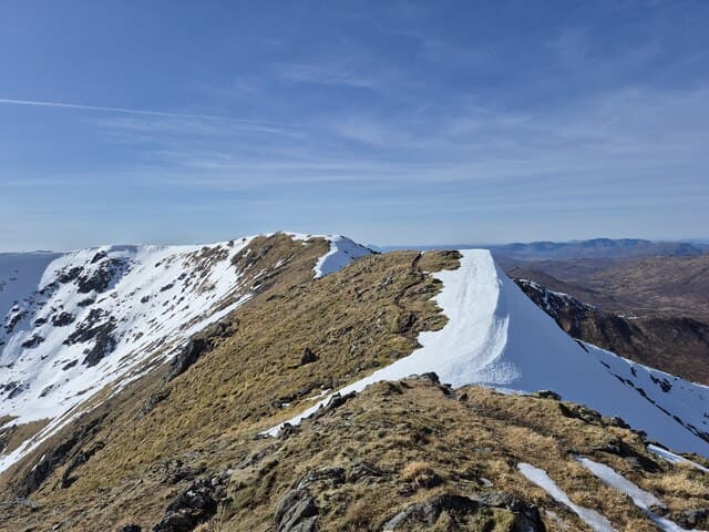
An Socach (1069m) is the westernmost Munro of the four-summit Glen Cannich / Mullardoch ridge, sitting at the head of Loch Mullardoch. It is one of the most remote of all Scottish Munros — there is no short way in, and most parties either commit to the full Mullardoch four-Munro round or take a boat across the loch. The summit is a rocky cone with views west into the heart of the Affric–Mullardoch wilderness.
Quick facts
- Height
- 1069m/ 3507ft
- Prominence
- 207 m
- Distance
- 18 km
- Ascent
- 941 m
- Time
- 7–10 hrs
- Grid ref
- NH100332
- Parking
- NH220316
- Nearest city
- Inverness· 58km
- Dogs
- Dogs on lead required near livestockDog-friendly guide ↗
Height and prominence cross-checked against the Database of British and Irish Hills (CC BY).
No GPX track yet
Walked this route? Share your track to help other walkers.
Standard route
Loch-side path 35% · Open hillside 40% · Summit plateau 25%
The classic round is the four-Munro Mullardoch traverse from the dam at the east end of Loch Mullardoch. Climb Càrn nan Gobhar first, then Sgurr na Lapaich, An Riabhachan and finally An Socach at the western end. Return along the south shore of Mullardoch — a long, rough, pathless tramp. Around 26km with 1700m of ascent. A boat shuttle across the loch (when running) cuts the return leg dramatically.
Terrain
The Mullardoch dam access road ends at a small car park; the path along the north shore is rough, undulating and slow — frequently overgrown. The climb onto Càrn nan Gobhar is steep grass; the higher ridges are mostly mossy turf with rocky summits. The descent off An Socach to the loch is pathless heathery hillside. The south-shore return is one of the longer rough walks in the Highlands. Plan an early start.
In winter
A serious, remote winter undertaking. The full four-Munro round in winter is among the longest single-day Scottish hill-days, with little possibility of bail-out once committed. The connecting ridges all develop cornices on their north sides. Mullardoch has no phone signal anywhere. Snow can persist on the higher slopes well into May. SAIS Northern Highlands applies. Plan for early start and consider winter daylight carefully.
This hill is in the Creag Meagaidh SAIS forecast area. Check SAIS forecasts in winter (December–April).
Best time of year
Getting there
- Glasgow3h 22m
- Edinburgh4h 47m
OS maps: OS Landranger 25
Mobile signal: No signal in the Mullardoch or remote Glen Affric area. Cannich is the last point with reliable 4G. Download maps at home or in Inverness.
Current conditions
Daylight Today
- Sunrise
- 05:00
- Sunset
- 21:55
- Civil dawn
- 04:03
- Civil dusk
- 22:51
NOAA Solar Calculator · 23 July 2026
Pair with
Curated multi-hill combinations from An Socach.
Around An Socach on the SCOT network
Getting there, basing yourself, and what to do off the hill.
An Socach — common questions
- How difficult is An Socach?
- An Socach carries a 5/5 (very challenging) grade on the OutdoorSCOT scale. Count on about 18km, 941m of ascent and a 7-10 hour day on the standard route. Terrain: The Mullardoch dam access road ends at a small car park; the path along the north shore is rough, undulating and slow — frequently overgrown.
- How prominent is An Socach?
- An Socach has 207m of topographic prominence — the height of its summit above the highest col connecting it to higher ground.
- Where should I park to climb An Socach?
- Standard parking is at NH220316. Check the parking grid reference on an OS map before travel; informal laybys can fill on summer weekends.
- When should I climb An Socach?
- The standard good-weather months for An Socach are May, June, July, August, September, October. Outside those months, expect winter conditions on the high ground — full mountain kit, navigation skills, and a check of the SAIS avalanche forecast for the relevant region.
- Can I bring my dog up An Socach?
- On a lead only — the route crosses ground with livestock or nesting-bird interest.
- What's mobile reception like on An Socach?
- No signal in the Mullardoch or remote Glen Affric area. Cannich is the last point with reliable 4G. Download maps at home or in Inverness.
- Is An Socach safe in winter?
- A serious, remote winter undertaking. The full four-Munro round in winter is among the longest single-day Scottish hill-days, with little possibility of bail-out once committed. The connecting ridges all develop cornices on their north sides. Mullardoch has no phone signal anywhere. Snow can persist on the higher slopes well into May. SAIS Northern Highlands applies. Plan for early start and consider winter daylight carefully.
Get the OutdoorSCOT weekly
One email a week — new route, hill and bothy guides, seasonal conditions and the odd hard-won lesson. No spam, unsubscribe in one click.