Munro · Central Highlands
Sgurr na Lapaich
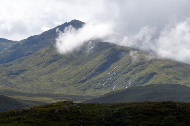
Sgurr na Lapaich is the 1152m high point of the Mullardoch ridge in the central Highlands, north of Loch Mullardoch — not to be confused with the smaller Sgurr na Lapaich of Glen Affric. With 841m of prominence it is one of the freestanding mountains of the Northern Highlands and the dominant peak of the long Strathfarrar / Mullardoch watershed. The summit is a large boulder on a small rocky platform with one of the broadest views in the country: Sutherland north, Knoydart west, the Cairngorms east.
Quick facts
- Height
- 1151.9m/ 3779ft
- Prominence
- 841 m
- Distance
- 19 km
- Ascent
- 1014 m
- Time
- 7–11 hrs
- Grid ref
- NH161351
- Parking
- NH220318
- Nearest city
- Inverness· 51km
- Dogs
- Dogs on lead required near livestockDog-friendly guide ↗
Height and prominence cross-checked against the Database of British and Irish Hills (CC BY).
No GPX track yet
Walked this route? Share your track to help other walkers.
Standard route
Glen road / cycle 35% · Open hillside 30% · Summit ridge 35%
The standard line is from the Loch Mullardoch dam at the head of Glen Cannich. Follow the loch shore path west for around 4km then climb the long south-east ridge of Sgurr na Lapaich, passing the small summit of Sgurr na Muice on the way. Around 19km return with 1014m of ascent. Strong walkers extend the day to An Riabhachan or An Socach for a multi-Munro Mullardoch round.
Terrain
The Mullardoch loch-shore path is firm but boggy in patches. The climb up the south-east ridge is on tussocky grass with rocky outcrops; the upper hill is short grass and small rock steps. A compact rocky platform forms the summit area, with the large summit boulder unmistakable from afar. The connecting ridges west to An Riabhachan are broad grassy walking with one or two narrow sections.
In winter
A serious winter Mullardoch outing. The summit ridge holds cornices on its north side above Coire Mhic-fhearchair. The Mullardoch dam road is single-track and rarely gritted past the dam — winter access can be slow. Phone signal is absent throughout. Full winter kit and competence essential; SAIS Northern Highlands applies.
This hill is in the Creag Meagaidh SAIS forecast area. Check SAIS forecasts in winter (December–April).
Best time of year
Getting there
- Glasgow3h 22m
- Edinburgh4h 45m
OS maps: OS Landranger 25
Mobile signal: No signal in Strathfarrar. The locked glen requires a permit and a cycle approach from Strathmore — no coverage from the gate onwards. Download maps at home.
Current conditions
Daylight Today
- Sunrise
- 04:59
- Sunset
- 21:54
- Civil dawn
- 04:02
- Civil dusk
- 22:51
NOAA Solar Calculator · 23 July 2026
Pair with
Curated multi-hill combinations from Sgurr na Lapaich.
On a long-distance route
Sgurr na Lapaich sits within 5km of these named long-distance walks — useful for trail-pack rest days or section extensions.
Around Sgurr na Lapaich on the SCOT network
Getting there, basing yourself, and what to do off the hill.
Sgurr na Lapaich — common questions
- What difficulty is Sgurr na Lapaich?
- On the OutdoorSCOT scale, Sgurr na Lapaich comes in at 5/5 — very challenging. Expect roughly 19km and 1014m of ascent on the usual route — 7-11 hours for most parties. Underfoot: The Mullardoch loch-shore path is firm but boggy in patches.
- What is Sgurr na Lapaich's prominence?
- 841m of prominence. That's the vertical drop from the summit to the col that links Sgurr na Lapaich to the next higher ground.
- Where do I park for Sgurr na Lapaich?
- Most walkers start from NH220318. Verify the grid reference on an OS map before you set off — space is tight on busy summer weekends.
- When is the best time to climb Sgurr na Lapaich?
- May, June, July, August, September, October give the most reliable conditions on Sgurr na Lapaich. Beyond that window the high ground turns wintry: carry full mountain kit, be confident navigating, and check the SAIS avalanche forecast for the area.
- Is Sgurr na Lapaich dog-friendly?
- Yes, but dogs must be kept on a lead — there is livestock or ground-nesting bird interest on the route.
- Is there mobile signal on Sgurr na Lapaich?
- No signal in Strathfarrar. The locked glen requires a permit and a cycle approach from Strathmore — no coverage from the gate onwards. Download maps at home.
- Is Sgurr na Lapaich safe in winter?
- A serious winter Mullardoch outing. The summit ridge holds cornices on its north side above Coire Mhic-fhearchair. The Mullardoch dam road is single-track and rarely gritted past the dam — winter access can be slow. Phone signal is absent throughout. Full winter kit and competence essential; SAIS Northern Highlands applies.
Get the OutdoorSCOT weekly
One email a week — new route, hill and bothy guides, seasonal conditions and the odd hard-won lesson. No spam, unsubscribe in one click.