Graham · North-West Highlands
Beinn na Muice
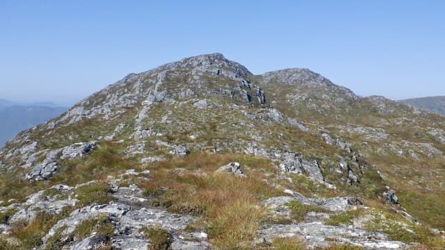
Beinn na Muice (693m) — hill of the pig — is a quiet heather summit at the head of Strath Bran, set in the NH24 square between Achanalt and Loch Fannich. The trig pillar marks the highest point of a long undulating ridge that drops sharply to the railway in Strath Bran. Outlook north is dominated by the great Fannich Munros.
Quick facts
- Height
- 693.8m/ 2276ft
- Prominence
- 161 m
- Distance
- 13 km
- Ascent
- 568 m
- Time
- 4–6 hrs
- Grid ref
- NH218402
- Parking
- NH221406
- Nearest city
- Inverness· 45km
- Dogs
- Dogs on lead required near livestockDog-friendly guide ↗
Height and prominence cross-checked against the Database of British and Irish Hills (CC BY).
No GPX track yet
Walked this route? Share your track to help other walkers.
Standard route
heather moorland 65% · rocky slopes 20% · grass and sedge 15%
From the small parking by the Achanalt level-crossing on the A832 follow the track south past the farm. Cross the open moor on a vague quad trail rising over peat hags to gain the north-east shoulder. The shoulder leads directly to the trig with one short pull through a band of outcrop at 600m.
Terrain
Quad track on the lower moor, then deep heather and peat hag above 400m. The north-east shoulder gives the best line — directly up the heathery face is rough and tiring. The summit area is short turf with a small rock platform.
In winter
The Strath Bran corridor is one of the colder spots in Wester Ross with easterly snow lying long. Cornices form along the eastern crags above the railway in big winters. SAIS Northern forecasts cover the Fannichs and give a useful read for this NH24 ridge.
This hill is in the Torridon SAIS forecast area. Check SAIS forecasts in winter (December–April).
Best time of year
Getting there
- Glasgow3h 26m
- Edinburgh4h 46m
OS maps: OS Landranger 25
Mobile signal: Minimal. Remote north-west Highlands; nothing works dependably here.
Current conditions
Daylight Today
- Sunrise
- 04:48
- Sunset
- 22:04
- Civil dawn
- 03:47
- Civil dusk
- 23:05
NOAA Solar Calculator · 17 July 2026
Around Beinn na Muice on the SCOT network
Getting there, basing yourself, and what to do off the hill.
Beinn na Muice — common questions
- How difficult is Beinn na Muice?
- Beinn na Muice carries a 4/5 (challenging) grade on the OutdoorSCOT scale. Count on about 13km, 568m of ascent and a 4-6 hour day on the standard route. Terrain: Quad track on the lower moor, then deep heather and peat hag above 400m.
- How prominent is Beinn na Muice?
- Beinn na Muice has 161m of topographic prominence — the height of its summit above the highest col connecting it to higher ground.
- Where should I park to climb Beinn na Muice?
- Standard parking is at NH221406. Check the parking grid reference on an OS map before travel; informal laybys can fill on summer weekends.
- When should I climb Beinn na Muice?
- The standard good-weather months for Beinn na Muice are March, April, May, June, July, August, September, October, November. Outside those months, expect winter conditions on the high ground — full mountain kit, navigation skills, and a check of the SAIS avalanche forecast for the relevant region.
- Can I bring my dog up Beinn na Muice?
- On a lead only — the route crosses ground with livestock or nesting-bird interest.
- What's mobile reception like on Beinn na Muice?
- Minimal. Remote north-west Highlands; nothing works dependably here.
- Is Beinn na Muice safe in winter?
- The Strath Bran corridor is one of the colder spots in Wester Ross with easterly snow lying long. Cornices form along the eastern crags above the railway in big winters. SAIS Northern forecasts cover the Fannichs and give a useful read for this NH24 ridge.
Get the OutdoorSCOT weekly
One email a week — new route, hill and bothy guides, seasonal conditions and the odd hard-won lesson. No spam, unsubscribe in one click.