Munro · North-West Highlands
Sgurr Fhuar-thuill
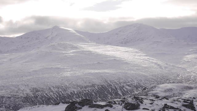
Sgurr Fhuar-thuill (1049m) — "peak of the cold hollow" — is the westernmost Munro of the four-summit Strathfarrar ridge, the long sweep of hills that walls in Glen Strathfarrar to the north. The ridge runs east–west for 7km at over 950m and is one of the great Highland traverses, taking in Sgurr Fhuar-thuill, Sgurr a' Choire Ghlais, Càrn nan Gobhar and Sgurr na Ruaidhe. The locked estate gate at Struy is managed by the landowners; verify timings well ahead.
Quick facts
- Height
- 1049.2m/ 3442ft
- Prominence
- 148 m
- Distance
- 18 km
- Ascent
- 923 m
- Time
- 6–10 hrs
- Grid ref
- NH235437
- Parking
- NH245418
- Nearest city
- Inverness· 43km
- Dogs
- Dogs on lead required near livestockDog-friendly guide ↗
Height and prominence cross-checked against the Database of British and Irish Hills (CC BY).
No GPX track yet
Walked this route? Share your track to help other walkers.
Standard route
Glen road / cycle 30% · Open hillside 35% · Ridge walk 35%
After clearing the locked gate at Struy, drive 17km up Glen Strathfarrar to the small parking area near Loch a' Mhuilidh. Climb steeply north onto Sgurr na Fearstaig (Top), then traverse east over Sgurr Fhuar-thuill, the deep bealach, and onto Sgurr a' Choire Ghlais, Càrn nan Gobhar and Sgurr na Ruaidhe. Return down the long east ridge of Sgurr na Ruaidhe and back along the glen road. Around 23km with 1500m of ascent for the full four-Munro round.
Terrain
The initial climb out of Glen Strathfarrar is steep heathery hillside with no clear path. Above 700m the ridge becomes a broad mossy crest, easy walking with rocky tops. Between Sgurr Fhuar-thuill and Sgurr a' Choire Ghlais the ridge narrows briefly with one short rocky step. The north face of Sgurr a' Choire Ghlais drops abruptly to Loch Toll a' Mhuic — keep clear of the corrie rim in mist. The descent off Sgurr na Ruaidhe is long pathless grass.
In winter
A serious winter ridge traverse. The Strathfarrar road through the locked gate is privately maintained and can be drifted closed even when the A831 outside is clear — check with the estate. All four summits develop consistent cornicing on their north flanks through the season. The north corries hold significant avalanche risk after south-westerly loading. Phone signal is absent. SAIS Northern Highlands applies.
This hill is in the Torridon SAIS forecast area. Check SAIS forecasts in winter (December–April).
Best time of year
Getting there
- Glasgow4h 30m
- Edinburgh4h 48m
OS maps: OS Landranger 25
Mobile signal: No signal in Strathfarrar. Stash maps before the gate — no coverage throughout the glen or on the ridge.
Current conditions
Daylight Today
- Sunrise
- 04:58
- Sunset
- 21:54
- Civil dawn
- 04:01
- Civil dusk
- 22:52
NOAA Solar Calculator · 23 July 2026
Pair with
Curated multi-hill combinations from Sgurr Fhuar-thuill.
Around Sgurr Fhuar-thuill on the SCOT network
Getting there, basing yourself, and what to do off the hill.
Sgurr Fhuar-thuill — common questions
- Is Sgurr Fhuar-thuill a hard climb?
- Sgurr Fhuar-thuill is rated 5/5 (very challenging) on the OutdoorSCOT scale. The standard route covers about 18km with 923m of ascent and takes most walkers 6-10 hours. Ground conditions: The initial climb out of Glen Strathfarrar is steep heathery hillside with no clear path.
- How much drop does Sgurr Fhuar-thuill have?
- The drop is 148m: measured from the summit of Sgurr Fhuar-thuill down to the saddle joining it to higher terrain.
- Where's the parking for Sgurr Fhuar-thuill?
- Park at NH245418. Double-check the grid reference on an OS map first; informal laybys here fill early in high season.
- What's the best month to climb Sgurr Fhuar-thuill?
- Aim for May, June, July, August, September, October on Sgurr Fhuar-thuill. In the remaining months treat it as a winter hill — full kit, solid navigation, and a look at the relevant SAIS avalanche forecast before you go.
- Can dogs go up Sgurr Fhuar-thuill?
- Dogs are fine on a lead. The route passes livestock or ground-nesting bird habitat, so keep them close throughout.
- Will I get phone signal on Sgurr Fhuar-thuill?
- No signal in Strathfarrar. Stash maps before the gate — no coverage throughout the glen or on the ridge.
- Is Sgurr Fhuar-thuill safe in winter?
- A serious winter ridge traverse. The Strathfarrar road through the locked gate is privately maintained and can be drifted closed even when the A831 outside is clear — check with the estate. All four summits develop consistent cornicing on their north flanks through the season. The north corries hold significant avalanche risk after south-westerly loading. Phone signal is absent. SAIS Northern Highlands applies.
Get the OutdoorSCOT weekly
One email a week — new route, hill and bothy guides, seasonal conditions and the odd hard-won lesson. No spam, unsubscribe in one click.