Corbett · North-West Highlands
Bac an Eich
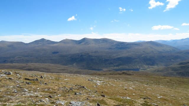
Bac an Eich — "the hummock of the horse" — rises on the south side of Strathconon, the long quiet glen running west from Marybank towards Loch Monar. At 849m it is the highest of a group of moorland hills overlooking Loch Beannacharain, with a 336m prominence that lifts it well clear of its neighbours. The summit is a rocky knoll above broad heather slopes with a far view westward into the Monar wilderness and back east across Strathconon to the Black Isle and the Moray Firth.
Quick facts
- Height
- 849m/ 2785ft
- Prominence
- 336 m
- Distance
- 15 km
- Ascent
- 747 m
- Time
- 5–8 hrs
- Grid ref
- NH222489
- Parking
- NH262508
- Nearest city
- Inverness· 44km
- Dogs
- Dogs on lead required near livestockDog-friendly guide ↗
Height and prominence cross-checked against the Database of British and Irish Hills (CC BY).
No GPX track yet
Walked this route? Share your track to help other walkers.
Standard route
stalkers path 25% · steep heather 35% · broad ridge 30% · rocky knoll 10%
Start from the public road end at Inverchoran in upper Strathconon and follow the stalkers path west through the trees and onto Loch Beannacharain shore. After around 3km, leave the loch path and climb steep grass and heather slopes south onto the north ridge of Bac an Eich. A long even pull on the ridge brings the rocky top. The full circuit is around 15km with 747m of climbing. Most baggers tackle the hill on its own; the neighbours are forestry and pathless ground.
Terrain
The Inverchoran stalkers path is well drained and clear. Off the path the slope is steep tussocky heather; the climb is unrelenting but never technical. The north ridge above 600m is short grass and small rock steps with the rocky summit knoll a clear landmark. The west drop is steep but not crag-bound. No exposure on the standard route.
In winter
A more serious winter Corbett than its modest height suggests — the climb is steep enough to need axe and crampons under snow, and the north ridge holds cornices in westerly winds. The Strathconon road is single-track and rarely gritted past Marybank; access in bad weather can be slow. Daylight short in midwinter; start early.
This hill is in the Torridon SAIS forecast area. Check SAIS forecasts in winter (December–April).
Best time of year
Getting there
- Glasgow4h 36m
- Edinburgh4h 54m
OS maps: OS Landranger 25
Mobile signal: No signal in upper Strathconon; intermittent at Marybank
Current conditions
Daylight Today
- Sunrise
- 04:41
- Sunset
- 22:10
- Civil dawn
- 03:37
- Civil dusk
- 23:14
NOAA Solar Calculator · 13 July 2026
Pair with
Curated multi-hill combinations from Bac an Eich.
Around Bac an Eich on the SCOT network
Getting there, basing yourself, and what to do off the hill.
Bac an Eich — common questions
- How difficult is Bac an Eich?
- Bac an Eich carries a 3/5 (moderately challenging) grade on the OutdoorSCOT scale. Count on about 15km, 747m of ascent and a 5-8 hour day on the standard route. Ground conditions: The Inverchoran stalkers path is well drained and clear.
- How much drop does Bac an Eich have?
- The drop is 336m: measured from the summit of Bac an Eich down to the saddle joining it to higher terrain.
- Where's the parking for Bac an Eich?
- Park at NH262508. Double-check the grid reference on an OS map first; informal laybys here fill early in high season.
- What's the best month to climb Bac an Eich?
- Aim for April, May, June, July, August, September, October on Bac an Eich. In the remaining months treat it as a winter hill — full kit, solid navigation, and a look at the relevant SAIS avalanche forecast before you go.
- Can dogs go up Bac an Eich?
- Dogs are fine on a lead. The route passes livestock or ground-nesting bird habitat, so keep them close throughout.
- Will I get phone signal on Bac an Eich?
- No signal in upper Strathconon; intermittent at Marybank
- Is Bac an Eich safe in winter?
- A more serious winter Corbett than its modest height suggests — the climb is steep enough to need axe and crampons under snow, and the north ridge holds cornices in westerly winds. The Strathconon road is single-track and rarely gritted past Marybank; access in bad weather can be slow. Daylight short in midwinter; start early.
Get the OutdoorSCOT weekly
One email a week — new route, hill and bothy guides, seasonal conditions and the odd hard-won lesson. No spam, unsubscribe in one click.