Graham · North-West Highlands
Meall na Faochaig
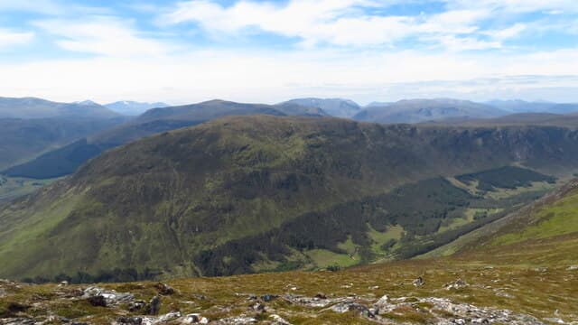
Meall na Faochaig (680m) is a heather-clad lump on the north side of Strathconon in NH25, its name translating as the hill of the whelks. It guards the entrance to the long Loch Beannacharain glen and offers a quiet half-day for visitors who venture beyond the usual Inverness honeypots. The cairn looks east toward the Beauly Firth and west into the Monar wilderness.
Quick facts
- Height
- 680.6m/ 2233ft
- Prominence
- 273 m
- Distance
- 13 km
- Ascent
- 558 m
- Time
- 4–6 hrs
- Grid ref
- NH257525
- Parking
- NH216559
- Nearest city
- Inverness· 41km
- Dogs
- Dogs on lead required near livestockDog-friendly guide ↗
Height and prominence cross-checked against the Database of British and Irish Hills (CC BY).
No GPX track yet
Walked this route? Share your track to help other walkers.
Standard route
heather moorland 65% · grass slopes 25% · rocky summit 10%
Start from the road end at Inverchoran in Strathconon and follow the rough estate track north-west for around 2km. Leave the track where it bends west and climb the southern flank directly on heather and bilberry, picking up a faint quad rut near 500m that leads to the summit dome. Descent by the same route is straightforward.
Terrain
Estate track on the lower flank, then ankle-deep heather with patches of soggy peat in any wet spell. The going firms up above 600m where short cropped grass and lichen take over. Quad ruts come and go but no continuous path exists to the cairn.
In winter
Strathconon catches the tail of Atlantic systems and Meall na Faochaig holds wet snow above 500m through mid-winter. The summit dome is a featureless place in cloud and the descent line is easy to lose. Ice axe is wise from January through March; crampons rarely needed on these gentle gradients.
This hill is in the Torridon SAIS forecast area. Check SAIS forecasts in winter (December–April).
Best time of year
Getting there
- Glasgow4h 39m
- Edinburgh4h 56m
OS maps: OS Landranger 25
Mobile signal: Poor. Remote Strathconon location; most networks barely reach.
Current conditions
Daylight Today
- Sunrise
- 04:47
- Sunset
- 22:05
- Civil dawn
- 03:46
- Civil dusk
- 23:06
NOAA Solar Calculator · 17 July 2026
Around Meall na Faochaig on the SCOT network
Getting there, basing yourself, and what to do off the hill.
Getting there: Dingwall station
Ben Wyvis approach; Easter Ross; junction for Kyle and Far North lines
30km from the hill
tripscot.co.uk
On TripSCOTBase yourself in Inverness
Highland capital — gateway to Cairngorms, Affric, Far North
41km from the hill
tripscot.co.uk
On TasteSCOTAfter the hill: Glen Ord
Muir of Ord — Black Isle distillery; the Singleton range's Highland anchor
27km from the hill
tastescot.co.uk
Meall na Faochaig — common questions
- How difficult is Meall na Faochaig?
- Meall na Faochaig carries a 4/5 (challenging) grade on the OutdoorSCOT scale. Count on about 13km, 558m of ascent and a 4-6 hour day on the standard route. Terrain: Estate track on the lower flank, then ankle-deep heather with patches of soggy peat in any wet spell.
- How prominent is Meall na Faochaig?
- Meall na Faochaig has 273m of topographic prominence — the height of its summit above the highest col connecting it to higher ground.
- Where should I park to climb Meall na Faochaig?
- Standard parking is at NH216559. Check the parking grid reference on an OS map before travel; informal laybys can fill on summer weekends.
- When should I climb Meall na Faochaig?
- The standard good-weather months for Meall na Faochaig are May, June, July, August, September. Outside those months, expect winter conditions on the high ground — full mountain kit, navigation skills, and a check of the SAIS avalanche forecast for the relevant region.
- Can I bring my dog up Meall na Faochaig?
- On a lead only — the route crosses ground with livestock or nesting-bird interest.
- What's mobile reception like on Meall na Faochaig?
- Poor. Remote Strathconon location; most networks barely reach.
- Is Meall na Faochaig safe in winter?
- Strathconon catches the tail of Atlantic systems and Meall na Faochaig holds wet snow above 500m through mid-winter. The summit dome is a featureless place in cloud and the descent line is easy to lose. Ice axe is wise from January through March; crampons rarely needed on these gentle gradients.
Get the OutdoorSCOT weekly
One email a week — new route, hill and bothy guides, seasonal conditions and the odd hard-won lesson. No spam, unsubscribe in one click.