Graham · North-West Highlands
Carn na Coinnich
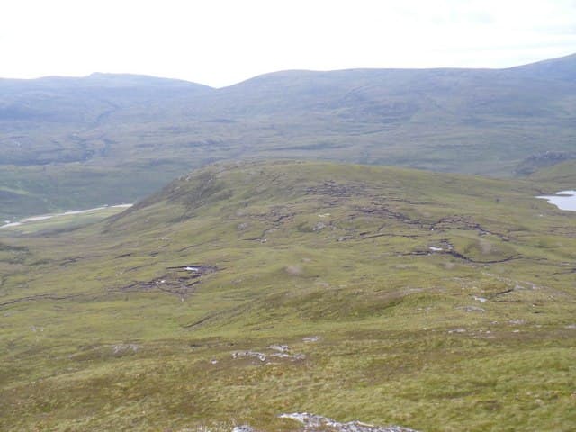
Carn na Coinnich (673m) — the meeting cairn — stands on the north side of Strathconon in the NH35 square, the trig pillar topping a broad moorland summit that looks east to the Black Isle and west toward the Munros of An Riabhachan. A natural pairing with Meall na Faochaig just to the west forms a fine long ridge day.
Quick facts
- Height
- 673.4m/ 2209ft
- Prominence
- 265 m
- Distance
- 13 km
- Ascent
- 552 m
- Time
- 4–6 hrs
- Grid ref
- NH324510
- Parking
- NH277492
- Nearest city
- Inverness· 35km
- Dogs
- Dogs on lead required near livestockDog-friendly guide ↗
Height and prominence cross-checked against the Database of British and Irish Hills (CC BY).
No GPX track yet
Walked this route? Share your track to help other walkers.
Standard route
heather moorland 65% · grass slopes 25% · rocky summit 10%
Start from the public road end at Scardroy Lodge in upper Strathconon and follow the Allt na h-Eilrig track north. Once above the steepening, leave the path and climb the heathery south-east ridge directly. The trig appears suddenly on the broad summit dome after a long stretch of cropped grass and bilberry — the view east opens to the firths in clear conditions.
Terrain
Estate track through Scardroy woodland, then a long heathery climb on the south-east ridge with no formal path. The summit dome is firm underfoot — cropped grass and bilberry replace the heather above 600m. Easy walking but a long approach from the gate.
In winter
Strathconon hills hold patchy snow on east and north faces with the broad summit dome usually wind-scoured. Whiteout navigation on the featureless top is the chief winter hazard. The trig serves as a confidence-building waypoint but is easily walked past in cloud.
This hill is in the Torridon SAIS forecast area. Check SAIS forecasts in winter (December–April).
Best time of year
Getting there
- Glasgow4h 36m
- Edinburgh4h 51m
OS maps: OS Landranger 26
Mobile signal: Poor. Remote Loch Monar/Strathfarrar area; limited coverage.
Current conditions
Daylight Today
- Sunrise
- 04:46
- Sunset
- 22:04
- Civil dawn
- 03:45
- Civil dusk
- 23:05
NOAA Solar Calculator · 17 July 2026
Around Carn na Coinnich on the SCOT network
Getting there, basing yourself, and what to do off the hill.
Getting there: Dingwall station
Ben Wyvis approach; Easter Ross; junction for Kyle and Far North lines
24km from the hill
tripscot.co.uk
On TripSCOTBase yourself in Inverness
Highland capital — gateway to Cairngorms, Affric, Far North
35km from the hill
tripscot.co.uk
On TasteSCOTAfter the hill: Glen Ord
Muir of Ord — Black Isle distillery; the Singleton range's Highland anchor
20km from the hill
tastescot.co.uk
Carn na Coinnich — common questions
- How difficult is Carn na Coinnich?
- Carn na Coinnich carries a 4/5 (challenging) grade on the OutdoorSCOT scale. Count on about 13km, 552m of ascent and a 4-6 hour day on the standard route. Underfoot: Estate track through Scardroy woodland, then a long heathery climb on the south-east ridge with no formal path.
- What is Carn na Coinnich's prominence?
- 265m of prominence. That's the vertical drop from the summit to the col that links Carn na Coinnich to the next higher ground.
- Where do I park for Carn na Coinnich?
- Most walkers start from NH277492. Verify the grid reference on an OS map before you set off — space is tight on busy summer weekends.
- When is the best time to climb Carn na Coinnich?
- May, June, July, August, September give the most reliable conditions on Carn na Coinnich. Beyond that window the high ground turns wintry: carry full mountain kit, be confident navigating, and check the SAIS avalanche forecast for the area.
- Is Carn na Coinnich dog-friendly?
- Yes, but dogs must be kept on a lead — there is livestock or ground-nesting bird interest on the route.
- Is there mobile signal on Carn na Coinnich?
- Poor. Remote Loch Monar/Strathfarrar area; limited coverage.
- Is Carn na Coinnich safe in winter?
- Strathconon hills hold patchy snow on east and north faces with the broad summit dome usually wind-scoured. Whiteout navigation on the featureless top is the chief winter hazard. The trig serves as a confidence-building waypoint but is easily walked past in cloud.
Get the OutdoorSCOT weekly
One email a week — new route, hill and bothy guides, seasonal conditions and the odd hard-won lesson. No spam, unsubscribe in one click.