Corbett · North-West Highlands
Sgurr a' Mhuilinn
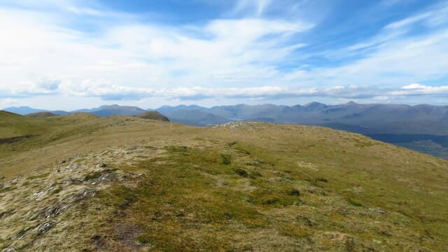
Sgùrr a' Mhuilinn — 'the mill peak' — is the high point of Strathconon, the long quiet glen running west from the Black Isle into the Monar hills. The 878m summit is the centrepiece of the Strathconon ridge — a north-east-to-south-west line linking several smaller tops with Sgùrr a' Mhuilinn as the dominant peak. The drive in from Muir of Ord is one of the loveliest single-track roads in Easter Ross, and the hill is reached from the road end at Scardroy with a short, steep ascent.
Quick facts
- Height
- 878.8m/ 2883ft
- Prominence
- 580 m
- Distance
- 10 km
- Ascent
- 850 m
- Time
- 3–5 hrs
- Grid ref
- NH264557
- Parking
- NH274515
- Nearest
- Ullapool· Inverness 41km
- Dogs
- Dogs on lead required near livestockDog-friendly guide ↗
Height and prominence cross-checked against the Database of British and Irish Hills (CC BY).
No GPX track yet
Walked this route? Share your track to help other walkers.
Standard route
glen track 25% · heather hillside 40% · grassy upper ridge 25% · summit area 10%
Park at the road end at Strathanmore in upper Strathconon (NH274515). Cross the river by the small bridge and follow a stalkers' path up the open hillside east-north-east, gaining the broad south-east ridge of Sgùrr a' Mhuilinn. The route climbs steadily to a sub-top, then crosses a small col before the final pull to the summit cairn. Allow 5–6 hours.
Terrain
Decent stalkers' path on the lower slopes — well-built for grouse moor management. The upper hill is heather and grass with rocky outcrops near the summit cone. The ridge between the sub-top and the main summit has a brief narrow section with mild exposure. Path becomes vague on the col.
In winter
A solid winter Corbett — the steady gradient and clear ridge make navigation straightforward, snow lies well on the north-east aspect, and the Strathconon road is generally cleared. Cornices form on the north side of the summit cone. The sub-top to summit traverse needs care in heavy wind.
This hill is in the Torridon SAIS forecast area. Check SAIS forecasts in winter (December–April).
Best time of year
Getting there
- Glasgow4h 43m
- Edinburgh4h 59m
OS maps: OS Landranger 25
Mobile signal: No signal in the Strathconon/Scardroy area
Current conditions
Daylight Today
- Sunrise
- 04:40
- Sunset
- 22:11
- Civil dawn
- 03:36
- Civil dusk
- 23:14
NOAA Solar Calculator · 13 July 2026
Pair with
Curated multi-hill combinations from Sgurr a' Mhuilinn.
Around Sgurr a' Mhuilinn on the SCOT network
Getting there, basing yourself, and what to do off the hill.
Getting there: Dingwall station
Ben Wyvis approach; Easter Ross; junction for Kyle and Far North lines
29km from the hill
tripscot.co.uk
On TripSCOTBase yourself in Ullapool
Main NW Highlands hub; Hebrides ferry; Inverpolly access
40km from the hill
tripscot.co.uk
On TasteSCOTAfter the hill: Glen Ord
Muir of Ord — Black Isle distillery; the Singleton range's Highland anchor
27km from the hill
tastescot.co.uk
Sgurr a' Mhuilinn — common questions
- How difficult is Sgurr a' Mhuilinn?
- Sgurr a' Mhuilinn carries a 2/5 (moderate) grade on the OutdoorSCOT scale. Count on about 10km, 850m of ascent and a 3-5 hour day on the standard route. Terrain: Decent stalkers' path on the lower slopes — well-built for grouse moor management.
- How prominent is Sgurr a' Mhuilinn?
- Sgurr a' Mhuilinn has 580m of topographic prominence — the height of its summit above the highest col connecting it to higher ground.
- Where should I park to climb Sgurr a' Mhuilinn?
- Standard parking is at NH274515 near Ullapool. Check the parking grid reference on an OS map before travel; informal laybys can fill on summer weekends.
- When should I climb Sgurr a' Mhuilinn?
- The standard good-weather months for Sgurr a' Mhuilinn are May, June, July, August, September. Outside those months, expect winter conditions on the high ground — full mountain kit, navigation skills, and a check of the SAIS avalanche forecast for the relevant region.
- Can I bring my dog up Sgurr a' Mhuilinn?
- On a lead only — the route crosses ground with livestock or nesting-bird interest.
- What's mobile reception like on Sgurr a' Mhuilinn?
- No signal in the Strathconon/Scardroy area
- Is Sgurr a' Mhuilinn safe in winter?
- A solid winter Corbett — the steady gradient and clear ridge make navigation straightforward, snow lies well on the north-east aspect, and the Strathconon road is generally cleared. Cornices form on the north side of the summit cone. The sub-top to summit traverse needs care in heavy wind.
Get the OutdoorSCOT weekly
One email a week — new route, hill and bothy guides, seasonal conditions and the odd hard-won lesson. No spam, unsubscribe in one click.