Corbett · North-West Highlands
Sgurr nan Ceannaichean
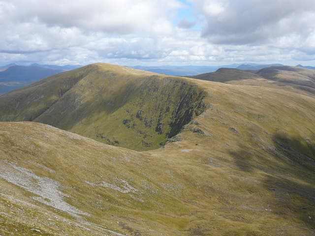
Sgurr nan Ceannaichean — "the peak of the pedlars" — rises south of Glen Carron between Achnashellach and Achnasheen, joined to the Munro Moruisg by a high bealach. It was a Munro itself until a 2009 resurvey trimmed its height by 35 centimetres and dropped it into the Corbett list, an event that briefly made it a minor celebrity among the hill-bagging community. The summit sits on the edge of a small crag with a long drop into Coire Toll nam Bian and gives a striking view west toward the Achnashellach forest hills.
Quick facts
- Height
- 913.43m/ 2997ft
- Prominence
- 185 m
- Distance
- 16 km
- Ascent
- 803 m
- Time
- 6–9 hrs
- Grid ref
- NH087480
- Parking
- NH079520
- Nearest
- Ullapool· Inverness 58km
- Dogs
- Dogs on lead required near livestockDog-friendly guide ↗
Height and prominence cross-checked against the Database of British and Irish Hills (CC BY).
No GPX track yet
Walked this route? Share your track to help other walkers.
Standard route
stalkers path 35% · corrie path 20% · steep east ridge 35% · summit top 10%
Park at the lay-by on the A890 by the bridge over the River Carron west of Glencarron Lodge and follow the path south up the Allt a Chonais glen. After around 4km a side path bears south-east into Coire Toll nam Bian, climbing gradually to the bealach below the east ridge of Sgurr nan Ceannaichean. From there a steep grass and rock pull gains the summit. Around 16km return with 803m of ascent. Many parties combine with Moruisg by traversing the long ridge between them.
Terrain
The Allt a Chonais path is firm and well drained for the first few kilometres but degrades to wet peat where it turns into the corrie. The bealach itself is a peat-hag basin in wet weather. The east ridge is steep grass with rocky steps and small bands of slabby outcrop — straightforward in dry conditions but slippery wet. The summit edge needs care; the drop into the eastern corrie is sudden.
In winter
In winter the east ridge collects west-facing snow and the cornice along the summit edge can be substantial after Atlantic storms — keep well back from the apparent rim. The Allt a Chonais path is generally clear at low levels but the bealach drifts up readily. With the road less than 200m above sea level, this is a relatively low-effort winter Corbett by Wester Ross standards, but conditions on the upper hill are full Highland.
This hill is in the Torridon SAIS forecast area. Check SAIS forecasts in winter (December–April).
Best time of year
Getting there
- Glasgow4h 38m
- Edinburgh4h 2m
OS maps: OS Landranger 25
Mobile signal: No bars on the approach or top — Monar Forest interior blocks all coverage
Current conditions
Daylight Today
- Sunrise
- 04:42
- Sunset
- 22:11
- Civil dawn
- 03:39
- Civil dusk
- 23:14
NOAA Solar Calculator · 13 July 2026
Pair with
Curated multi-hill combinations from Sgurr nan Ceannaichean.
Around Sgurr nan Ceannaichean on the SCOT network
Getting there, basing yourself, and what to do off the hill.
Sgurr nan Ceannaichean — common questions
- How difficult is Sgurr nan Ceannaichean?
- Sgurr nan Ceannaichean carries a 3/5 (moderately challenging) grade on the OutdoorSCOT scale. Count on about 16km, 803m of ascent and a 6-9 hour day on the standard route. Underfoot: The Allt a Chonais path is firm and well drained for the first few kilometres but degrades to wet peat where it turns into the corrie.
- What is Sgurr nan Ceannaichean's prominence?
- 185m of prominence. That's the vertical drop from the summit to the col that links Sgurr nan Ceannaichean to the next higher ground.
- Where do I park for Sgurr nan Ceannaichean?
- Most walkers start from NH079520 near Ullapool. Verify the grid reference on an OS map before you set off — space is tight on busy summer weekends.
- When is the best time to climb Sgurr nan Ceannaichean?
- May, June, July, August, September, October give the most reliable conditions on Sgurr nan Ceannaichean. Beyond that window the high ground turns wintry: carry full mountain kit, be confident navigating, and check the SAIS avalanche forecast for the area.
- Is Sgurr nan Ceannaichean dog-friendly?
- Yes, but dogs must be kept on a lead — there is livestock or ground-nesting bird interest on the route.
- Is there mobile signal on Sgurr nan Ceannaichean?
- No bars on the approach or top — Monar Forest interior blocks all coverage
- Is Sgurr nan Ceannaichean safe in winter?
- In winter the east ridge collects west-facing snow and the cornice along the summit edge can be substantial after Atlantic storms — keep well back from the apparent rim. The Allt a Chonais path is generally clear at low levels but the bealach drifts up readily. With the road less than 200m above sea level, this is a relatively low-effort winter Corbett by Wester Ross standards, but conditions on the upper hill are full Highland.
Get the OutdoorSCOT weekly
One email a week — new route, hill and bothy guides, seasonal conditions and the odd hard-won lesson. No spam, unsubscribe in one click.