Corbett · North-West Highlands
Beinn Tharsuinn
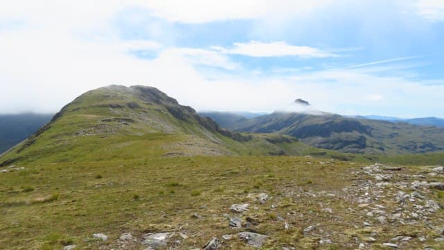
Beinn Tharsuinn — 'the transverse hill' — sits at 861m on the watershed between Strathconon and Glen Carron, north of Achnasheen. Its summit looks across at Bidean an Eoin Dèirg, Maoile Lunndaidh and the wide moorland of Strath Bran. Solo ascents are rare; the hill more commonly gets bagged on an extended Strathconon round or in combination with the Attadale Corbett cluster to the south.
Quick facts
- Height
- 861.2m/ 2825ft
- Prominence
- 224 m
- Distance
- 22 km
- Ascent
- 950 m
- Time
- 6–9 hrs
- Grid ref
- NH055433
- Parking
- NH274515
- Nearest
- Ullapool· Inverness 61km
- Dogs
- Dogs on lead required near livestockDog-friendly guide ↗
Height and prominence cross-checked against the Database of British and Irish Hills (CC BY).
No GPX track yet
Walked this route? Share your track to help other walkers.
Standard route
stalkers path 30% · rough heather 40% · grassy upper ridge 20% · summit area 10%
Drive up Strathconon to the parking near Strathanmore (NH274515), at the end of a long single-track approach past Loch Beannacharain. From there, walking the estate track six kilometres west sets you up to climb north onto the wide south-east shoulder. A long steady pull leads to the summit cairn. For the larger Attadale round, traverse west across Bidean an Eoin Dèirg and beyond. Round trip 9–10 hours.
Terrain
Estate track on the long approach — quick walking but tedious in distance. Off the track, the ground is rough heather and grass dotted with peat hag in the bealachs. The summit area is firm rock and grass with a clear cairn. Drier underfoot than the western Wester Ross hills because of the Strathconon position.
In winter
Snow holds well on the summit ridge through January and February. The long Strathconon drive can be slow and weather-dependent. No avalanche concerns on the standard south-east ridge. A reasonable solo Corbett day in firm conditions but pace it carefully — the round trip from Strathanmore is long for a winter daylight window.
This hill is in the Torridon SAIS forecast area. Check SAIS forecasts in winter (December–April).
Best time of year
Getting there
- Glasgow4h 34m
- Edinburgh4h 59m
OS maps: OS Landranger 25
Mobile signal: EE/Vodafone usable in Strathconon village; weakens up the glen; no signal in the upper estate or on the summit
Current conditions
Daylight Today
- Sunrise
- 04:42
- Sunset
- 22:11
- Civil dawn
- 03:39
- Civil dusk
- 23:14
NOAA Solar Calculator · 13 July 2026
Around Beinn Tharsuinn on the SCOT network
Getting there, basing yourself, and what to do off the hill.
Beinn Tharsuinn — common questions
- Is Beinn Tharsuinn a hard climb?
- Beinn Tharsuinn is rated 3/5 (moderately challenging) on the OutdoorSCOT scale. The standard route covers about 22km with 950m of ascent and takes most walkers 6-9 hours. Ground conditions: Estate track on the long approach — quick walking but tedious in distance.
- How much drop does Beinn Tharsuinn have?
- The drop is 224m: measured from the summit of Beinn Tharsuinn down to the saddle joining it to higher terrain.
- Where's the parking for Beinn Tharsuinn?
- Park at NH274515 near Ullapool. Double-check the grid reference on an OS map first; informal laybys here fill early in high season.
- What's the best month to climb Beinn Tharsuinn?
- Aim for May, June, July, August, September, October on Beinn Tharsuinn. In the remaining months treat it as a winter hill — full kit, solid navigation, and a look at the relevant SAIS avalanche forecast before you go.
- Can dogs go up Beinn Tharsuinn?
- Dogs are fine on a lead. The route passes livestock or ground-nesting bird habitat, so keep them close throughout.
- Will I get phone signal on Beinn Tharsuinn?
- EE/Vodafone usable in Strathconon village; weakens up the glen; no signal in the upper estate or on the summit
- Is Beinn Tharsuinn safe in winter?
- Snow holds well on the summit ridge through January and February. The long Strathconon drive can be slow and weather-dependent. No avalanche concerns on the standard south-east ridge. A reasonable solo Corbett day in firm conditions but pace it carefully — the round trip from Strathanmore is long for a winter daylight window.
Get the OutdoorSCOT weekly
One email a week — new route, hill and bothy guides, seasonal conditions and the odd hard-won lesson. No spam, unsubscribe in one click.